Issued at 1500BST on Tue 26th Sep based on Tue 26th Sep 00Z Model Runs
Key Points
Discussion:
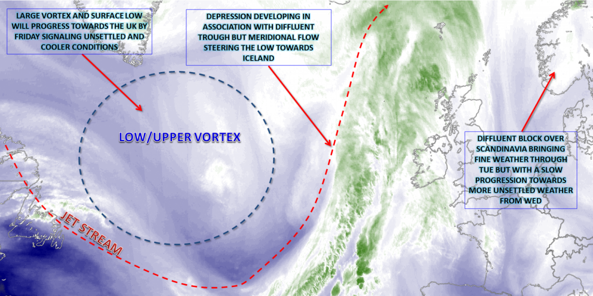
Wed 27th Sep: Into Wednesday and it is a definite case of two large-scale patterns trying to battle it out across the N Atlantic and into N Europe. A high-pressure blocking area, to the NE, remains influential and that has been keeping Atlantic frontal zones at bay. However, a well-established large-scale vortex within the N Atlantic with some cyclonic developments within its base will become increasingly dominant, from the W, as the day progresses. However, the blocking pattern will remain sufficiently dominant to the NE, to signal mainly dry conditions persisting across many N and E areas of the British Isles through the day.

Through the day all the 00Z GM’s, along with HRES models, indicate quite active frontal zones will move into W and SW areas. Well forced and with an associated WBPT plume, then some heavy rain is certainly possible at times. Mid and upper-level winds will be from the S or SW and this, as a result, means that the frontal zones will struggle to make progress further N and E, against the continued block to the NE. As a result, a distinct E and W split in conditions will develop through the day. Moderate or, at times, heavy rain across Ireland, Wales and SW England, will bring locally large rainfall totals, but then moving into parts of W and SW Scotland, NW England, Midlands and S England later in the day. Ahead of this, so across E England and E Scotland then another predominantly dry day is forecast, with some sunny spells. This distinct E and W split in conditions is highlighted well by the 24hr precipitation totals for Wednesday.

Thu 28th Sep: As we move into Thursday and the associated frontal zone, bringing Wednesday’s wet weather, will have cleared away to the NE, but perhaps bringing some patchy rain and drizzle to E Scotland and E England through much of the morning. The forcing, by this point though, will have relaxed away and no heavy precipitation will be likely. Following on will be a minor and transient ridge of high pressure, ahead of further cyclonic conditions to the W of Ireland. As a result, Thursday is expected to be a relatively fine and dry day. Some bright or sunny spells are forecast, by many of the HRES models out to T+48hrs, and while the next frontal system will arrive from the W, it won’t move into Ireland until the evening.

The 00Z UKMO, GFS, ECMWF and GEM are all in good agreement with this pattern across the UK, but there are some model differences over the timing of the first clearing away. As a result, there is at least a risk that some eastern areas of Scotland, along with E England, could maintain cloudy and damp conditions for much of the day, but, overall, it is likely to become drier and brighter here too through the afternoon. Our MR model highlights this small ‘window’ of better weather across many regions through the day, in-between the weakening front and the next, more active front, from the W later in the day.

Fri 29th Sep: We end the working week with a concerted eastwards progression of cyclonic conditions across the British Isles. The blocking high to the NE will still be in evidence, but its centre of gravity will have declined to the E, across more eastern regions of Scandinavia. This process, as a result, means that a more progressive pattern can then begin to develop across the N Atlantic, allowing the more cyclonic conditions to move eastwards across many areas. At the same time, there is a good model agreement for a mainly zonal jet to exit out of E Canada, this having vital importance on the weekend's cyclonic developments.
Across the British Isles, there is a good model agreement for a frontal zone to be moving eastwards through the morning. There are some differences over the amount of forcing associated with the front, but it is likely to bring a more general region of the rain eastwards through the morning and into the early afternoon. A clearance is forecast to follow from the W, but with then sea-based convection is setting up as mid and upper-level temperatures fall from the W. As a result by late Friday showery weather is forecast to have moved into Scotland, Ireland and perhaps some other W regions of England and Wales too. However, once the morning frontal zone has cleared E, then some drier and brighter weather is likely. The 00Z GEM model highlights this evolution well, note some reasonable amounts of forcing along the front too.

The other important aspect of the weather on Friday will be a general change in wind direction. Prior days will maintain S or SW’ly winds, primarily due to the orientation of the block to the NE and the lower pressure to the W. However, following the eastward frontal zone will be a drop in theta-e and 850mb temperatures too. As a result, this will then lead to a drop in temperatures back to nearer averages for late September, a trend that will continue into the coming weekend.

Sat 30th Sep and Sun 1st Oct: Into the final day of September and the opening day of October and we see a zonal pattern develop across the N Atlantic and across into the UK. There are, given this more unsettled regime, uncertainties over the details, particularly regarding frontal timings and also to the extent of any cyclogenesis to the W of the UK as well. Saturday may well provide a window of better weather, ahead of developing lows to the W, with some bright or sunny spells and scattered showers. However, it is upstream that is of significance with a highly zonal and powerful jet stream pattern, this all associated with a marked region of baroclinicity. 850mb temperatures will range between -5C, or below, just to S of Greenland, but potentially be above +15C just to the E and SE of Newfoundland, meaning that an approximately 20C 850mb thermal gradient. As a result, a marked region of baroclinicity, and it is within this region that some potential significant low-pressure development is forecast.

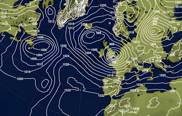
After the reasonable day on Saturday, the current evolution is towards a more pronounced spell of wet and windy conditions then moving eastwards through the course of Sunday. A period of wet weather, perhaps with some moderate or heavy rain, is forecast across many areas, but with a potential clearance from the W later in the day. The low-pressure systems within the N Atlantic are, by Sunday, likely to contain the remnants of both Hurricane Maria and Lee. When combined with the jet stream and strong baroclinic zone, this heightens the risk of some rapid cyclogenesis later in the weekend. The overnight UKMO FAX chart, for 12Z Sat 30th, highlights the potential cyclonic developments across the N Atlantic well.

By the end of the weekend, so T+144h 0000Z Mon 2nd Oct, the ECMWF, GFS, UKMO and GEM all show some potential for a vigorous low pressure to be affecting the UK. The details of this are unknown at the moment, but the UKMO and, particularly the 00Z GFS, would lead to a risk of gales as well for parts of the N and W later in the weekend as we see a far more cyclonic period of weather as October starts.

Medium and Longer Term 2nd Oct onwards:
Looking ahead and the more cyclonic start to October is forecast to dominate the opening week or so at the moment, especially across more N and W areas. Heavy rain, high winds and gales seem possible. However, through the first half of October, there are developing signs that this more cyclonic pattern may well then give way to a more anticyclonic regime towards the middle of the month. Perhaps initially across southern areas of the British Isles, but then perhaps more widely. The recent EC Monthly, along with some Rossby Wave Analysis does lend some support to this potential development. As a result, a prolonged run of cyclonic conditions well into October isn't likely at the moment. We may see a transition to the first period of more general settled conditions, with mist, fog and frost with time, of which is something we’ll be keeping an eye on in the coming days and weeks.

Loading recent activity...