Issued at 1500BST on Thu 14th Sep based on Thu 14th Sep 00Z Model Runs
Key Points
Overview:
In what was a frequent occurrence during the summer period, high pressure and a more anticyclonic regime were often present within the medium and longer term. Despite, at times, some good model agreement, especially within the likes of the EC ENS and the GFS ENS, the signal for higher pressure was never consistent. As a result, by the time the period in question arrived, the overall forecast had changed, and we were within, overall, another cyclonic pattern and that was the ‘routine’ of the summer. Early September has produced an abrupt arrival of autumn. Low pressure and unsettled conditions, along with below average temperatures have and continue to dominate. In recent days, or within the last week, there were some strong signals for a build of pressure towards and beyond mid-month, but as with summer, that signal is now waning as the days continue to progress.
Synoptic Discussion:
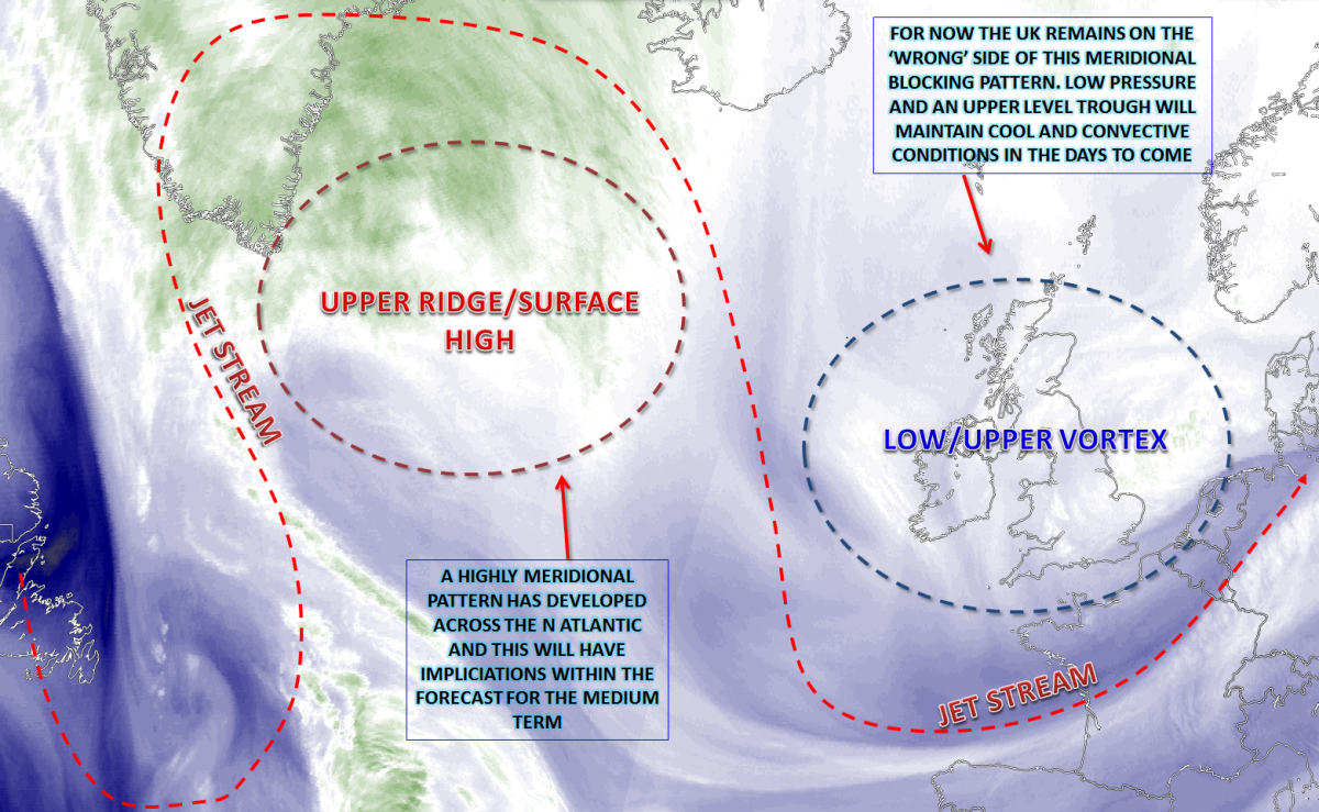
There has been a fundamental change in recent days though across the N Atlantic with regards to the overall pattern. In the last few weeks, there has been a pronounced jet stream, of which has been particularly active and progressive and of which has led to some cyclonic events and, predominantly, unsettled conditions through to the middle of the month and even going back to late August. However, the development of some significant WAA across the eastern seaboard of the USA and up towards NE Canada has aided in allowing for a more amplified pattern, an Omega Block. Between E Canada and NW Europe, there is now a distinct meridional flow and this will have implications on the forecast within the medium term.
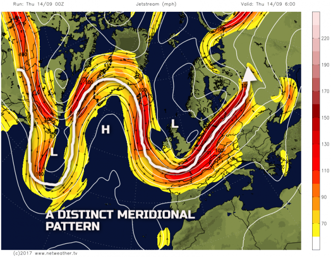
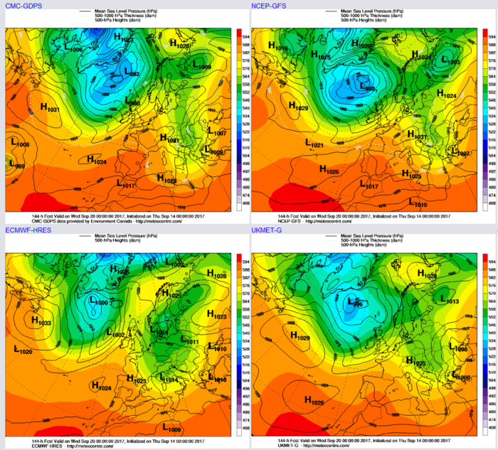
The problem, from a UK’s point of view within the short term, is that we continue to sit at the base of a marked long wave upper trough. This upper trough was showing signs of retreating this coming weekend eastwards, as the slowly progressive pattern allowed for the ridge within the N Atlantic to build into the British Isles. However, even this pattern has backtracked in recent days and, as is often the case with Omega Blocks, if you end up within one of the long wave troughs then the weather can remain mainly static. The weather, as a result, across much of the British Isles through the rest of the week and into the weekend will be cool and cyclonic. The air mass will be unstable at times, especially across England and Wales. By the time we get to Sunday and Monday though there will likely be an anticyclonic-trough-disruption process taking place, which, as a result, would likely mean a more general progression towards an anticyclonic pattern. As a result, initially, Scotland and Ireland may well have a reasonable day on Sunday, while showery elsewhere, but with than a possible brief ridge pattern developing into early next week for most areas.
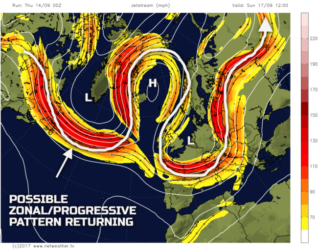
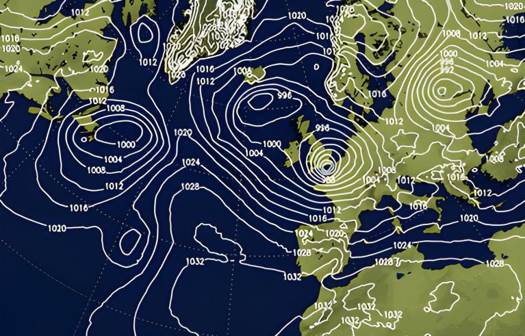
The developing cut-off high pressure to the NW of the British Isles is highlighted well on the above chart. Importantly, however, going off the GFS at least is the possible progression of a more zonal and progressive pattern once again over the N Atlantic that may well under-cut this developing ridge to the NW. The 00Z UKMO, ECMWF, GFS and GEM are, however, in reasonable agreement that the upper vortex that will dominate to the E in the coming days will finally decline away. A transient ridge is then set to build across the British Isles early next week bringing a likely more settled spell. However, earlier this week it was at this point in the month when a more pronounced build of pressure was in evidence across the UK, this now seems unlikely.
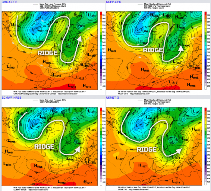
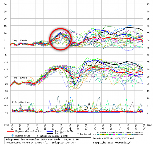
The crucial aspect and period of the forecast within the medium and longer term, so towards the 19th and 20th of the month and beyond, is whether the more zonal flow, exiting out of E Canada will under-cut the building ridge to the NW. If this ridged pattern becomes a cut-off surface high pressure, then it is likely that a more progressive flow will evolve. However, it is these finer details that are particularly delicate, and there may well be some model changes yet before a more definitive evolution is determined. That aside though, and, again, within recent days the progression has now been towards a more unsettled period of weather making a return from the W or SW. What this may well do though is finally lead to a change in air mass, with the current and up-coming Pm or Am N or NW’ly, being replaced by a Tm SW’ly flow. As a result, there is some confidence to suggest that the second half of September will see somewhat warmer conditions. The 00Z GFS ENS highlight this with some distinct peaks in 850mb temperatures through the second half of the month than compared with the first half.
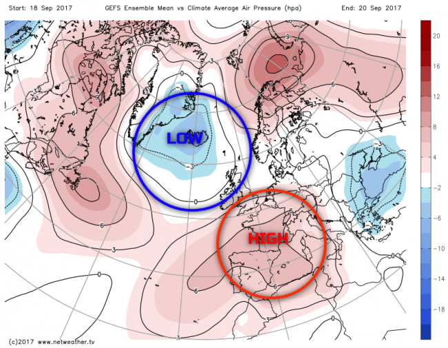
By the time we get towards the 20th of the month, so the middle and latter half of next week, there is some model agreement that the more progressive pattern will begin to arrive. However, WAA from the SW could well lead to a more pronounced rise in pressure to the S and SE of the British Isles. As a result, this means that somewhat warmer conditions will develop, but with an N and W, S and E split in the weather arriving and of which would be more like the typical pattern for this of year. Scotland and Ireland, perhaps N England, would become more unsettled again, while mainly dry and relatively warm weather develops across southern and eastern areas of England.
Overall, this is the expected evolution now through to the middle and latter half of next week; with a chilly, convective and cyclonic within the short term. It may then potentially become drier and more settled for many, albeit briefly, early next week but with more unsettled conditions returning into the N and W, but with a warmer trend through the second half of the month. The 00Z GFS ENS highlights this expected pattern next week well, noting the signal for lower than average pressure, compared to a climatological background to the NW, while pressure is higher just to the S and SE.
Long Term (22nd to 30th Sep)
As we look towards the final third, or so, of the month and confidence in the forecast quickly becomes low, if not very low. The primary problem is that there is still a lack of any distinct global drivers at this time of year to help potentially determine some broader weather patterns and evolutions. Equally, the continued above average Atlantic Hurricane Season is forecast to continue. Any additional tropical features, especially those that become tropical storms or hurricanes and then of which potentially drift northwards into the N Atlantic have the potential to change the pattern across the N Atlantic quickly. For example, a sudden injection of WAA up the eastern seaboard of the US can have significant impacts, downstream, potentially leading to amplification of the pattern and perhaps even allowing the Azores high to extend NE up into the UK. Equally, a more cyclonic pattern could become established again, in association with any amplification of the pattern, just like is the case now.
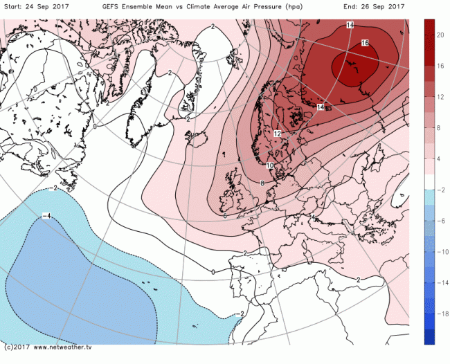
Examination of the current long term products, so the EC and GFS ENS, plus the EC Monthly, all indicate very different outcomes. Highlighting this, from the 00Z model runs is the GFS ENS. Note by the time we get to the 26th of September; the latest model run has a significant blocking pattern over Scandinavia extending westwards into NW Europe and of which would signal a more settled end of the month, potentially warmer too depending on the finer details. However, to balance this out, there are more cyclonic possibilities as well. In short, there’s a lot to play for during the remainder of September with potentially some late dry and warm weather, but, equally, further autumnal conditions may arise too.
Loading recent activity...