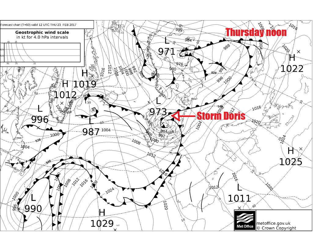
Storm Doris, the fourth-named storm since beginning of last Autumn will cross northern UK on Thursday, bringing damaging 60-80mph wind gusts to central parts and snow to Scotland and higher ground of northern England.
Following pretty quiet weather of late, with spring-like conditions across eastern England yesterday, with the mercury hitting 18.3C at Kew Gardens and Northolt in London yesterday, it’s all change to wet, very windy and colder weather later this week. An area of low pressure rapidly deepening in a kink in the jet stream as it crosses Northern Ireland and the far north of England on Thursday is forecast to potentially bring wind gusts of 60-80mph across a central swathe of Britain during the morning, along with snow across Scotland and higher parts of northern England. This deep low was named “Storm Doris” by the Met Office this morning and will be the forth-named storm since the beginning of last autumn.
Thought we'd already had Storm Doris earlier this month? Well some of the papers and online news feeds may have mislead you to think so, but Thursday's storm is officially the real 'Doris', my colleague Jo Farrow explains more:
Storm Doris starts life as a frontal wave mid-North Atlantic tomorrow.
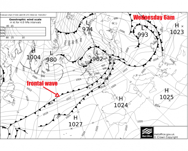
A low forms on the wave Wednesday PM, as a shortwave upper trough of cold air and dry air intrusion behind it descending from the lower stratosphere originating from the Canadian arctic moves out across the N Atlantic and engages the wave.
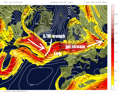
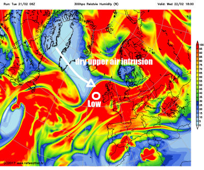
Where the upper level dry air intrusion, characterised strong potential vorticity, overruns the baroclinic zone and warm conveyor (frontal boundary) it induces cyclonic circulation, thus a low deepens along the frontal boundary in the wave. The low then undergoes rapid cyclogenesis as it's pushed by the shortwave on to the cold (north) side of the polar front jet stream and also comes under the developmental ‘left-exit’ of the jet steam – an area where diverging winds aloft cause convergence at the surface and pressure to fall.
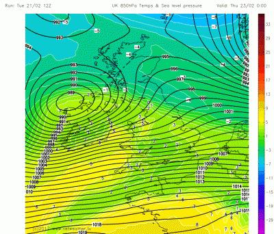
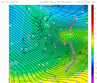
Doris crosses east over N Ireland and northern England on current model guidance. On 12z (latest) GFS run today, the low’s central pressure is ~ 989mb at 00z just west NW Ireland on Thursday, 12 hours later it’s 974mb over the North Sea off the North Yorks coast. The track and timing of Doris may change though compared to current model runs.
Winds
Storm Doris is forecast to bring 60-80mph wind gusts across north Wales, parts of northern England, The North Midlands, Lincolnshire across to Norfolk on Thursday, as per amber “be prepared” warning area on the Met Office warning. Gusts of 50-60mph likely elsewhere across England, Wales and SE Scotland as per yellow “be aware” warning area on the Met Office warning.
Winds this strong could potentially cause disruption to travel and power supplies, flying debris that could cause injury, bring down trees and cause damage to property. The Met Office “be prepared” is to “watch out for falling trees or tiles … secure garden furniture and move vehicles to a safe place”
Snow & Heavy Rain
In addition, heavy rain will sweep across many areas as Storm Doris tracks across northern Britain, which could cause some difficult driving conditions combined with the strong winds, along with localised flooding.
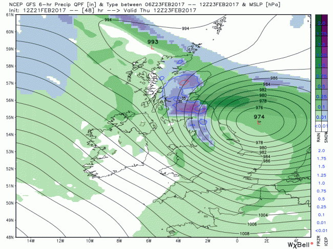
The rain is likely to turn to snow during the morning across Scotland and northern England as Doris clears eastwards into the North Sea and the winds turn northerly - bringing in colder arctic air turning rain to snow. Greatest accumulations over the hills but perhaps to lower levels too across Scotland for a time. The heaviest and most persistent snow forecast to coincide with the Thursday morning rush hour too. Snow accumulations of 5 to 10cm are possible over hills, perhaps 10-20cm over the highest parts of the Pennines and southern Uplands. Lower elevations from central lowlands northwards could expect to see 2 to 5cm for a time in the morning before melting.
The combination of 50-60mph wind gusts and snow across southern uplands and northern Pennines may allow for blizzard conditions and drifting of snow to develop during Thursday morning before conditions ease into the afternoon. The strong winds and wet snow could bring down powerlines causing power disruptions and create hazard driving conditions – particularly over higher routes.
Loading recent activity...