The weather looks to remain changeable to see out July and to start August, with some days cloudy with showers, other days dry with some warm sunshine. Temperatures will remain around average for the time of year.
The weather looks to end July on a rather average theme temperature wise over the next few days, though it will be changeable, with some dry and sunny weather but also some showers too, which will turn heavy and thundery later in the week. A far cry from the beginning of July, which saw a heatwave, with the temperature on the 1st reaching 35.8C at Faversham in Kent.
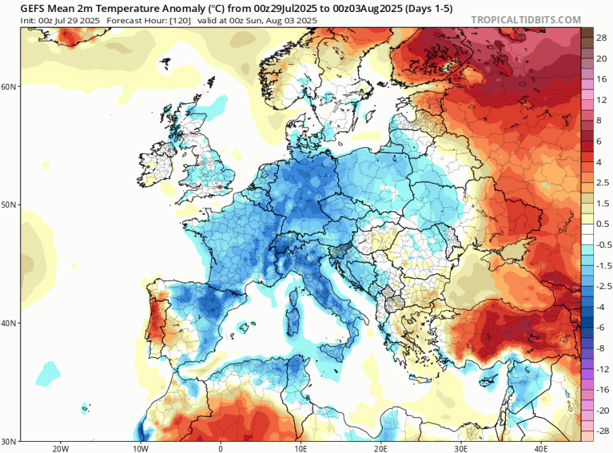
Temperatures around average over the next 5 days to end July and start August. Mainland Europe below average.
Today will see more in the way of cloud along with patchy rain for England and Wales, after a dry and sunny day yesterday. Tomorrow should see a better chance of sunny spells and staying dry, but showers will develop in places. Thursday and Friday more unsettled again, with rain spreading east Thursday morning, followed by heavy showers and thunderstorms developing towards the east Thursday and Friday afternoons, but with some sunny spells too. Temperatures for the rest of the week will be close to average, though it will feel humid at times.
Cloudy skies for many across England and Wales this morning, with a frontal system sliding southeast bringing patchy outbreaks of rain, though the far north and east of England along Cornwall may stay mostly dry and bright. Morning rain clearing England and Wales to a brighter afternoon, but sunny spells will trigger some sharp showers in places. Scotland and N. Ireland escaping with a mostly dry day with sunny spells, though the odd shower can’t be ruled out across western Scotland and N. Ireland. Feeling humid in the south, though temperatures a touch down on yesterday in the cloudier parts, generally reaching 18-21C, perhaps 23C where we see some sunshine in the southwest.
Wednesday will be mostly dry for many, best chance of sunshine across western areas, more in the way of cloud building across the east after a sunny start, with some mainly light showers developing, though many will miss them here. Turning cloudier across Ireland and N. Ireland, with some showery rain developing. Warm in the sunshine, temperatures reaching 20-24C.
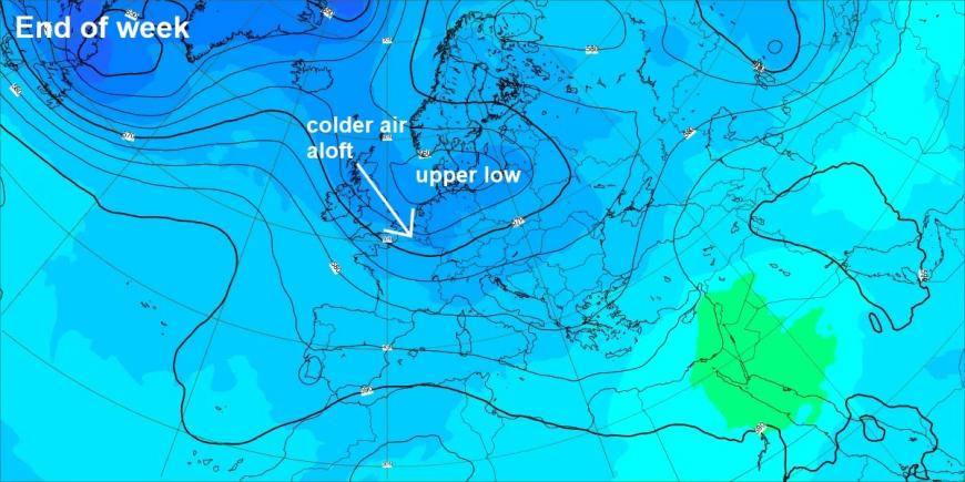
Later this week, changes will occur over the far north Atlantic, with a wedge of cold air aloft spreading southeast into an upper low to the east of the UK. This will make the northwesterly flow unstable, particularly towards eastern Britain.
Thursday looks to see a frontal system move southeast across England and Wales in the morning, bringing a spell of rain, then followed by sunny spells and heavy showers and thunderstorms developing across southern, central and eastern England, some scattered showers elsewhere too, turning drier across the west in the afternoon.
Heavy showers and thunderstorms likely towards eastern areas on Thursday & Friday
Friday will see further heavy showers and thunderstorms develop towards eastern areas of England during the day, while a ridge of high pressure looks to develop towards the west, so it will be drier and sunnier here, with just a few scattered showers near coasts here.
Saturday may end up a mostly fine and settled day, thanks to a temporary ridge of high pressure building in from the west, with some warm sunny spells for many. Sunday will probably see the ridge flatten to allow a frontal system to move east off the Atlantic, though some uncertainty how far south the rain along the fronts will get, could be all areas or confined to the north.
Last few ECWMF runs have show a deep low crossing over or close to Scotland early next week
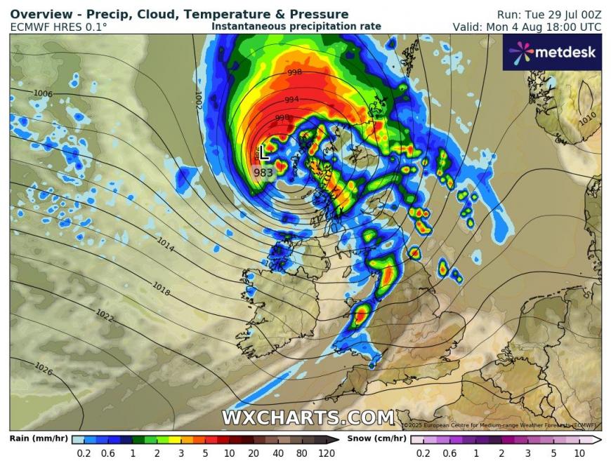
The last few runs of the ECMWF model have been indicating an unseasonably deep low crossing close to or over the north of Britain next Monday or Tuesday. This low starts its life along the Eastern seaboard of the USA before crossing northeast over the Atlantic and coming under the influence of a very strong jet streak over the North Atlantic - under which the low looks to deepen on the approach to the UK and Ireland as it moves on to the cold side of the jet stream. Probably a low likelihood of a low this deep coming off, but needs to be watched. GFS has a shallower area of low pressure tracking further south, as it stays on the warm side of the jet stream and so fails to deepen.
Strong jet stream moving out of Canada over the N Atlantic later this week and through the weekend could spawn a deeping low to cross the UK early next week
The changeable theme looks to continue next week with upper trough and area of low pressure governing NW Europe.
Loading recent activity...