It’s been a varied week with a change from the fresh northwesterly flow to a warm and humid airmass accompanied by heavy downpours and thunderstorms. There have been some cracking storms, lightning shows and torrential downpours.
Low pressure was forecast to sit off eastern Scotland on Friday. There is a mass of cloud linked to this low pressure with some damp or showery but muggy weather. Southeastern Britain has clearer skies, and so in the sunshine it feels warm and humid. What had been more uncertain was a possible second low heading for southern Britain on Saturday. It is now forecast to move eastwards over Wales and England at the start of the weekend, with another showery low pressure heading for Ireland later on Sunday. The outlook for Bank Holiday Monday is fresher with a west to northwesterly wind. It will still feel warm in any sunshine but the air is turning cooler. So certainly not a hot or humid Monday, but although there will be bands and clusters of showers marching eastwards, there will be a good deal of bright and fine weather in between. A mixed Monday, but not a right off. (No Bank Holiday in Scotland).

"Thunderstorms most likely across Wales, central, northern and eastern England - with a risk of hail, gusty winds and localised flooding, though the cooler, low shear airmass will not support any organised severe weather today." Convective Forecast for Friday 28th
There has to be some irony in this change to gloomy weather as Plug-In solar panels go on sale in the UK finally. After months of heat and drought, the clouds appear and it rains, finally. Anyway, these panels would be a longer-term investment and hopefully an exciting development once things settle in.
“With the UK having some of the oldest and least energy efficient housing stock in Europe, making energy-saving technologies easier to access will be an important part of helping people reduce their energy bills and supporting the transition to a lower-carbon future.”

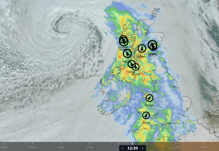
Netweather Radar (extra) showing top 10 temperatures after 11am and lightning (dots)
The Met Office has a yellow warning for thunderstorms over northern and eastern England, the Midlands and much of inland Wales for the second half of Friday.
“While many areas will miss the heaviest downpours, heavy showers and thunderstorms are expected to develop during Friday afternoon and evening… Lightning and hail will be additional hazards in a few locations. Heavy showers and thunderstorms will gradually ease during Friday evening.” MO


Friday evening
There will be more settled and drier weather from the west on Friday evening. If you are caught under one of the isolated heavy showers for England (clusters around Leicestershire and The Wash, into Norfolk showing on the UKV model), you will know about it. It will be blustery for southeast England, especially Kent and Brighton, in a southwesterly wind. Closer to the first low centre, there will be more cloud and wet weather for NE Scotland with a brisk N/NW wind.

Saturday
After a mild and quiet night for most with lighter winds, the second low pressure will bring a band of rain over southwest Britain. There will be more warm and humid air caught up in this, but with all the cloud cover, temperatures struggle without the sunshine. Generally, we will be looking at 19 to 22C. There will be some morning sunshine for parts of northern Britain, and Scotland could feel warm at 19 or 20C with hardly any breeze.

As the frontal band edges northwards over Wales and England, there will be heavy, perhaps thundery showers following. Swinging up from southwest England, over the West Country. Across southern England and the Midlands into East Anglia by Saturday evening. Again, some places will miss these and others get a soaking. Welcome rain for the gardens and fields, but did it have to arrive on a long weekend?
This frontal rain is forecast to move over County Down, maybe Antrim and south Armagh during the day on Saturday but to pull away by the evening. In any sunshine to the west, temperatures could reach 22C.

There could be some movement on where the frontal band ends up, so bear that in mind if you are looking at symbols on an hourly forecast. There is rain over northern England and the risk of showers for southern counties and East Anglia and a blustery westerly wind by morning. Everything continues to move northeastwards overnight with a new band of heavy showers for western Scotland early on Sunday.
Sunday
With a brisk southerly wind for Cornwall, it will feel cooler as the showers arrive. This weekend’s second low pressure will have cleared away over the North Sea with a lot of warm and humid air, but a hang-back of cloud for SE Britain. The third low pressure will bring distinct bands of heavy showers in from the Atlantic. Again they will be thundery at times. And in between there will be fair weather with bright or sunny spells, allowing temperatures up to 22 to 25C.

During Sunday afternoon, as the low centre moves towards Britain, there will be more showers and more heavy downpours. These continue to rotate around the low pressure during Sunday night and will be slow-moving over northern Britain.

The signal for a change to fresher conditions from the northwest has been showing for several days. Eastern Britain should feel similar to Sunday with plenty of sunshine. However, further west and northwest the breeze will feel cooler and fresher through the day. The fresh breeze will pick up through the day, apart from for eastern Scotland and northeast England, where there will be slow-moving heavy showers, mixed with bright spells. Through the day, the risk of showers transfers from Northern Ireland and western Britain, over to eastern Britain late afternoon. Again, you could enjoy some fine sunny weather but prepare for the chance of rain.
Loading recent activity...