The Stratospheric Polar Vortex, according to GFS analysis is 0.3 m/s at 00z at 10 hPa 60N, there could technically be a Sudden Stratospheric Warming (SSW) - if lasts 24 hours or more, which would be the earliest on record! After a weak recovery, another go at reversal looks to occur in around 5 days time, but it could be again brief and not make the 24 hours to be a technical SSW.
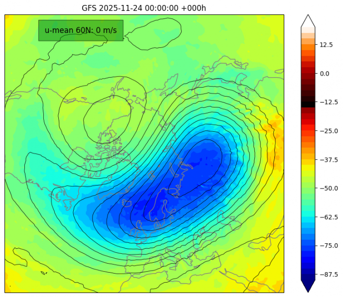
However, this stratospheric warming or SSW looks to be of reflective type, reflection of planetary waves upwards into the stratosphere look to be reflected back down into the troposphere, leading to a quick termination of the warming episode due to the reflection of planetary waves in the stratosphere, which leads to an amplification of tropospheric planetary waves inducing strong westerlies over the North Atlantic and blocking over the North Pacific sector.
The other type of SSW is the absorbing type, which you may be more familiar with, where upward planetary waves are absorbed in the stratosphere leading to a strong deceleration of westerly winds in the upper stratosphere - with a disappearance in the polar night jet. This weakening of zonal (westerly) winds descends from the lower stratosphere further down into the troposphere - which then induces high latitude blocking in the weeks following the SSW event. This can increase the chance for cold outbreaks to develop over northern Europe and USA, as cold arctic air is pushed out from the polar regions by the high latitude blocking.
With the reflective type of SSW occurring before the end of the month, it looks likely that tropospheric polar vortex will strengthen over polar region of northern Canada and Greenland, strengthening the westerly flow across the Atlantic, so it looks like the UK and Ireland will be in for a few weeks of unsettled, sometimes windy and often mild conditions off the Atlantic, with the flow from the southwest.
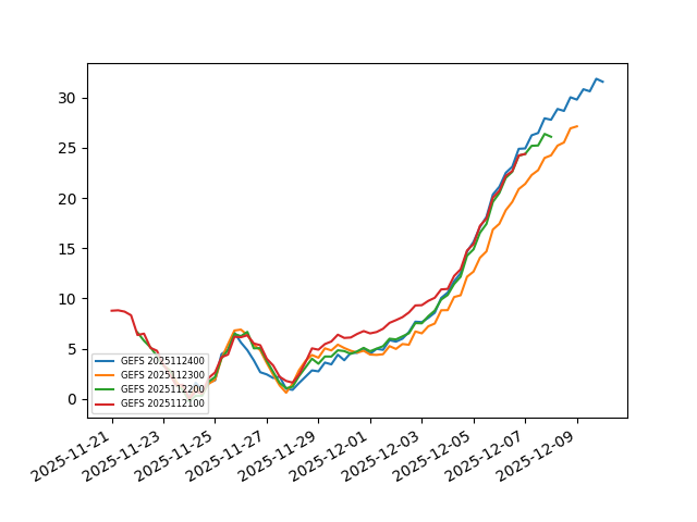
The strengthening tropospheric polar vortex (TPV) over northern Canada / western Greenland looks to be decoupled from the polar stratosphere - which will undergo weakening with a rise in geopotential heights from warming of the stratosphere from the Canadian side of the pole. This means the strong TPV could last through a large part of December, the first half of the month at least. A strengthening of the zonal jet stream across the North Atlantic aimed at northwest Europe looks to occur as we head into the start of December. This could bring stormy weather at times to the UK and Ireland, perhaps even a named storm or two.
Jet stream looks to strengthen as we head into early December, bringing unsettled and potentially stormy weather
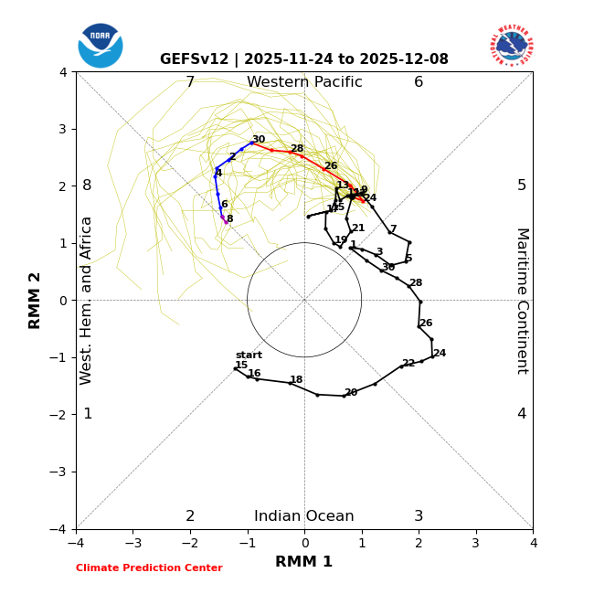
However, there is one other driver of global weather patterns that may break us out of this ominous stormy and mild pattern that would likely otherwise last through December. The Madden Julian Oscillation (MJO), a tropical-based forcing, looks to move into phase 7 at the end of this month and early December, where enhanced rainfall moves eastward over the western Pacific.This phase tends to promote blocking high pressure to build over northern Europe 2 to 3 weeks later, which can lead to colder and drier weather, but also a risk of snow in places.
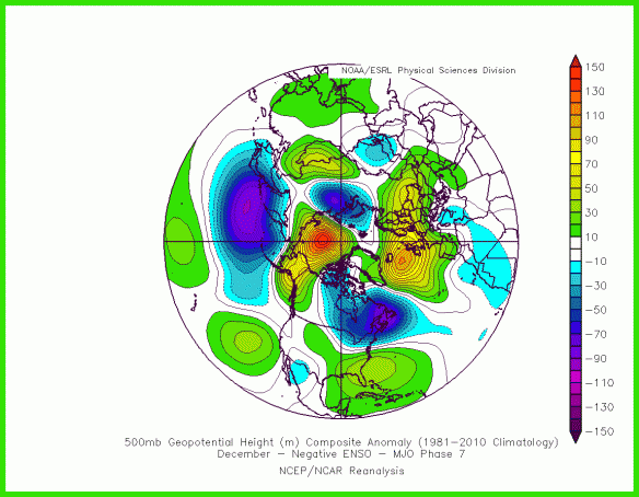
Composite of 500 hPa heights following phase 7 in December during La Nina - blocking over N Europe.
The change to more blocked weather patterns may occur after mid-December, as a result of the MJO passage over the western Pacific changing weather patterns in the mid to high latitudes of the northern hemisphere. However, if the restrengthening stratospheric polar vortex couples with the troposphere, then we could see a continuation of strong westerlies / jet stream affecting northwest Europe through much of December - bringing mild, unsettled and perhaps stormy weather. A great deal of uncertainty, so we will keep you posted on what it’s looking like in the run up to the Christmas period. Certainly no signs of cold and wintry weather returning anytime soon after it turns milder later this week.
Loading recent activity...