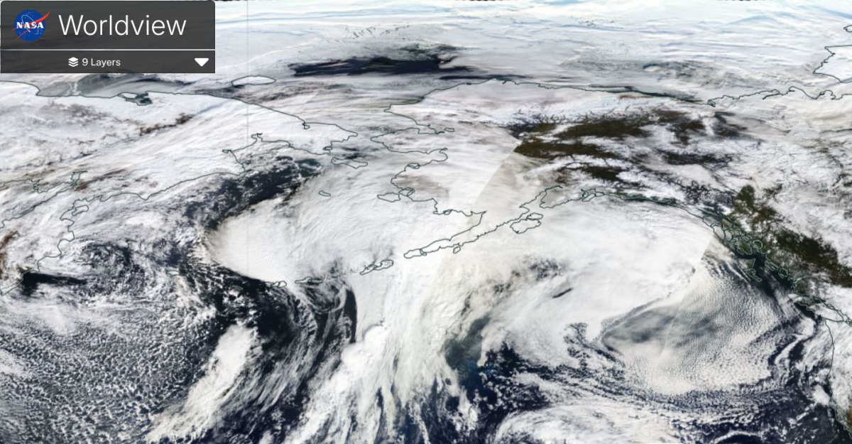
At this time of year, Alaska expects strong storms to arrive off the Bering Sea from the northwest Pacific. Very wet and very windy weather is a way of life before the ice and snow of winter. However, over the weekend of 12th October, an intense sea storm arrived, causing devastating damage to western Alaska. This storm included the remnants of Typhoon Halong. There were hurricane force winds and a record-breaking storm surge. At least one person has died as more than 1,400 people were displaced by the storm. The Yukon-Kuskokwim (Y-K) Delta region was severely affected as a huge storm surge joined high tides with an onshore SW wind causing rivers to back up. This isolated area is mostly populated by indigenous people with a complex history of why they are in such a flood-prone region.
The land is very flat here and vulnerable to storm surge and as homes became surrounded by several feet of floodwaters, the village of Kipnuk saw record water levels. The surge of water flooded roads and buildings, pushing homes off their foundations. There has been footage of entire houses floating away, miles inland, some with residents still trapped inside them. The landscape has been devastated with homes ruined and power, water and fuel supplies severely impacted along with some communications. There was a large-scale rescue of hundreds of people, including some from the roofs of houses.
Typhoon Halong had impacted Japan peaking to the south of Tokyo as the equivalent of a category 4 hurricane. It did stay out at sea, but there was disruption to transport south of Tokyo with damage to remote small islands.
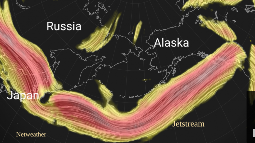
Much like in the northern Atlantic, tropical cyclones can move northwards over cooler ocean waters and transition into an extra-tropical low, caught up in the jetstream. Northwestern Europe and the UK are often impacted by these deep autumn low pressures. Western Alaska saw catastrophic flooding in this ex-typhoon event.
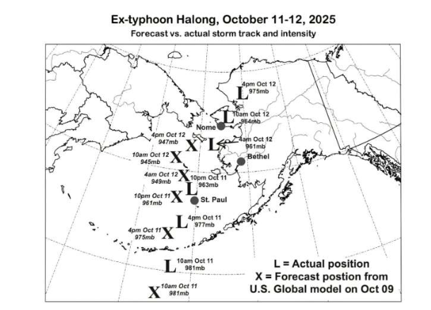
Credit Phys.org GM model tracking compared to actual position
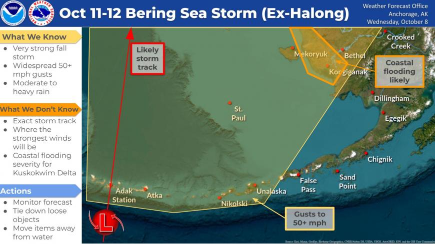
The forecast models did not handle the track well initially. Model output had kept the vigorous low further away from the Alaskan west coast and although there were updates and shifts in the forecast, it didn’t allow enough time for mass evacuations. The storm tracked further east than expected, reaching the Y-K Delta early on Sunday morning.
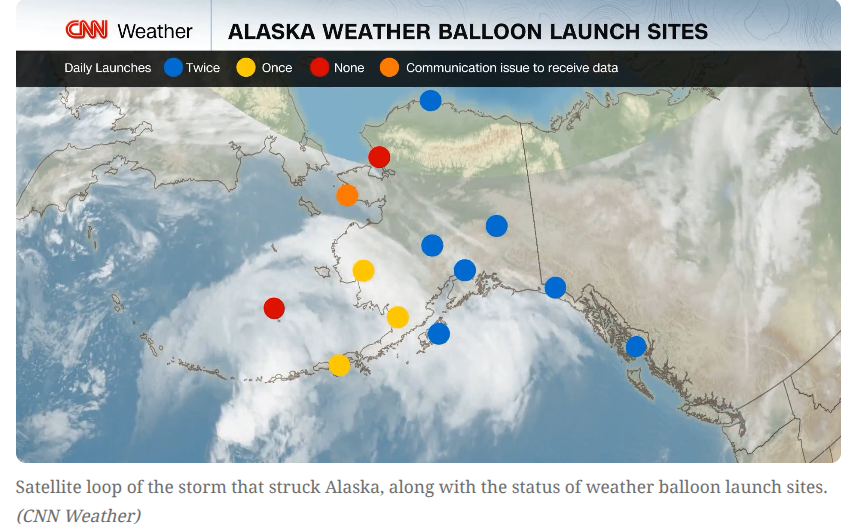
There is also the issue of National Weather Service budget cuts, as Alaska is the 49th state of the United States, since 1959. There has been a reduction in weather balloon launches since February over much of this region. The balloons take radiosonde recorders up through the atmosphere and they relay valuable 3D observational data back into the start of the modelling. This forms part of the base picture for running the forecasts.
Rick Thoman, an Alaska climate specialist , University of Alaska, Fairbanks, described this storm as the nightmare scenario for forecasters, with a depleted NWS leading to fewer weather balloon launches in the runup to a major storm. The impacts at any given place are extremely sensitive to the exact track and strength of the storm.
As our climate changes and severe weather events become more intense with higher impacts, the ability to warn people and for them to have time for action becomes even more important. It needs investment. The recent UN International Day for Disaster Risk Reduction spoke of funding resilience, not just funding disaster relief, and quality early warnings are a key part of this, along with community resilience and useful preparation planning.
Rick Thoman warned the Y-K Delta area faces a dangerous combination of threats; the region’s land is sinking due to permafrost thaw while sea levels continue to rise.
Thoman said the double threat makes the area increasingly vulnerable to future storms and flooding during high tides. He also noted climate change is contributing to warmer ocean temperatures, which can “supercharge” storms and potentially make them more intense.
Multiple agencies assisted with the rescue and evacuation operation; the Alaska State Troopers, the Alaska National Guard, and the U.S. Coast Guard, as helicopters were used to rescue people from flooded, isolated areas. Military aircraft evacuated hundreds to Bethal which was soon overwhelmed so around 600 have now been taken on to the capital, Anchorage, for emergency shelter and aid.
As always in such an event, it highlights our reliance on technology. Forecasting has improved hugely over recent decades with powerful computer modelling and satellite imagery, now the use of AI. However, in remote, exposed parts of the world, sometimes local knowledge, history and shared real-time information are a very important addition to technology. Timely preparations are very important and the initial community response afterwards is so important to help save lives, often in a time of chaos and reduce the feeling of crisis. It is not possible to forecast every impact.
While the immediate danger has passed, the road to recovery for Kipnuk and other western Alaska coastal communities will be hard in this remote part of North America.
Loading recent activity...