High pressure will remain firmly in charge as we go through the rest of the week keeping most dry and settled, so there will be little change in the weather, other than where it will remain cloudy and where sunny spells develop - which will vary day-to-day. Where skies clear at night, there could be a touch of frost in more rural areas. By day, it will be pleasantly warm, though, where the sun comes out.
Changes afoot this weekend, as high pressure drifts away to allow pressure to move in from the Atlantic
However, after a fortnight of high pressure, finally a change to more usual October weather is on the way this weekend, as high pressure centred over northern UK drifts southeast across central then eastern Europe this weekend, allowing Atlantic frontal systems with spells of rain to move in from the west on Sunday, followed by areas of low pressure moving in next week, bringing further spells of rain or showers and windier conditions too.
For now, it will be mostly dry today, but remain rather cloudy for many with a blanket of stratocumulus trapped under high pressure system centred across the north, bringing overcast skies known as ‘Anticyclonic Gloom’ The weaker sun now not having the strength to burn off cloud like it does in summer. The cloud will be thick enough along some eastern coastal areas and hills for some patchy drizzle, where there will be subtle flow off the North Sea, however, models suggest some sunny spells will develop across Scotland away from eastern coasts, NW England, west Wales and SW England through the day. Where the sun appears, temperatures could reach 16-17C, low to mid-teens where it remains cloudy.
Chasing breaks in the cloud this week for some sunshine
Similar conditions on Wednesday, with eastern, central and southern parts most likely seeing cloud persist, thick enough to bring some drizzle on east facing coasts and over hills. Some sunshine developing across Scotland away from eastern coasts, NW England, Wales and SW England.
Not much change on Thursday and Friday, other than there may be subtle changes in cloud distribution, with southern areas joining western areas with some sunshine developing after a cloud start. Perhaps more in the way of cloud spreading down across central and northern areas, with some patchy light rain or drizzle for northern and eastern Scotland and perhaps NE England.
A southeasterly breeze developing, brisk in the west, on Saturday. Perhaps rather cloudy in the west, with some patchy rain possibly moving in across the far west in the evening, heralding the change mentioned for the weekend, brighter in the east, with some sunshine developing.
Some uncertainty on timings, but we may see outbreaks of rain spread eastwards during Sunday and turning windier too. Though some parts in the east may stay dry and perhaps bright.
Next week looking much more unsettled, as the jet stream which has been diverted well to the south of the UK over SW Europe by blocking high pressure over NW Europe moves back towards it’s more usual path aimed at NW Europe. This will bring areas of low pressure east off the Atlantic across or near the UK, bringing spells of rain or showers and it will be windy at times too. More typical autumnal weather!
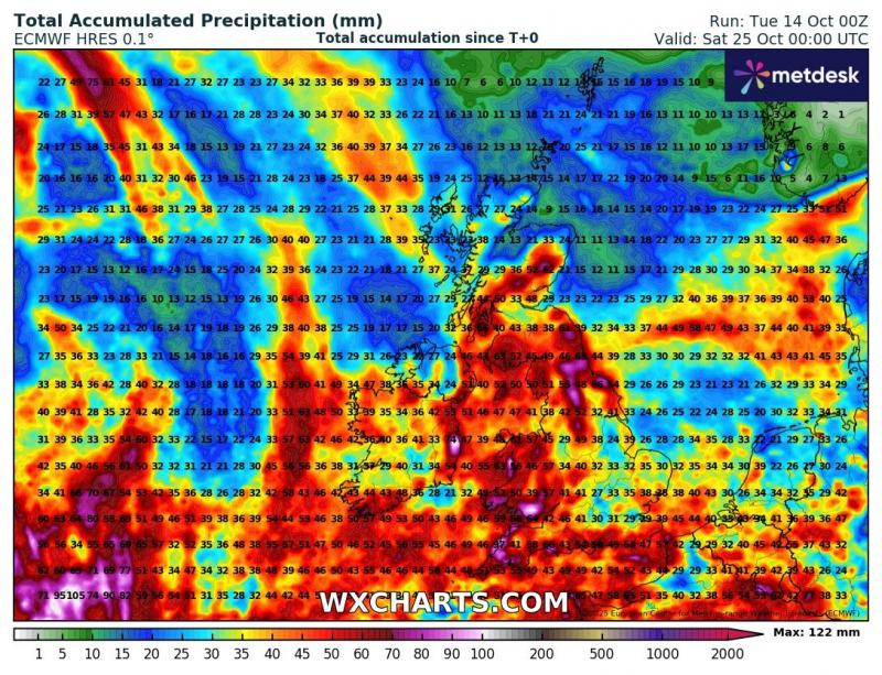
There is some uncertainty, though, over how slow-moving areas of low pressure will be. ECMWF is more slow-moving, bringing larger rainfall totals, while GFS is more progressive, bringing spells of rain through more quickly. Too far out to say yet how wet it could be.
ECMWF rainfall totals until Sat 25th
GFS rainfall totals until Sat 25th
.jpg?w=800)
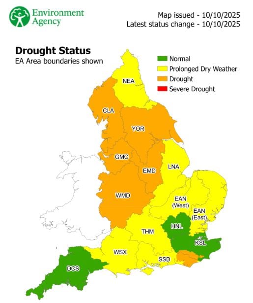
However, many areas need the rain, with some areas of the UK officially still in drought conditions. But it’s going to take a very wet rest of autumn and a very wet winter to make up the deficit caused by an exceptionally dry spring and summer this year.
Loading recent activity...