With numerous warnings for wind and rain, Storm Amy will arrive later on Friday and bring a windy Saturday to much of the UK. Severe gales for Northern Ireland and Scotland this evening and a wild night.
With rain across much of the UK, the winds are beginning to strengthen ahead of Storm Amy. This significant windstorm will bring wild conditions by Friday evening to parts of the UK and Ireland. It might be time to find a torch and just check outside to see if anything needs securing. There have been school closures in Northern Ireland for Friday afternoon to get children and staff home before the conditions deteriorated, and power outages are expected in the gales. The Education Authority announced
"Emergency Early School Closure - Storm Amy All schools located in the areas affected by the amber weather warning in Northern Ireland are required to close at 12 midday today, Friday 03 October 2025. (Counties Antrim, Londonderry, Tyrone and Fermanagh)" @Ed_Authority

Met Éireann Status Red - Wind warning for Donegal Storm Amy: Extremely strong and gusty southwest winds.
In Scotland, Scotrail began advising customers to plan ahead yesterday, “as Storm Amy is expected to bring severe weather conditions across Scotland… with the potential for widespread disruption to rail services.” Several lines will close from 18.00 on Friday due to the stormy weather. Calmac Ferries along the west coast had cancellations or possible disruption identified on all 30 of their routes showing on their website by Friday morning. For the Northern Isles, NorthLink Ferries have announced, “Due to forecasted adverse weather conditions, these sailings are now cancelled.”

Rain
The UK and Ireland will see a spell of wet weather as the heavy rain from the warm front continues eastwards today. This will mainly affect northern Britain by late afternoon, clearing from Northern Ireland and moving through the Northern Isles this evening.
The rain warning over Northern Ireland ends at 5pm but the rain warning for NW England continues from mid-afternoon til midnight. There will be heavy and persistent rain this afternoon and then more showery, heavy downpours into the evening before some improvement. The following cold front will include some intense rainfall and potentially gusty winds.

The rain warning over parts of mainland Scotland and the Western Isles continues throughout Saturday. There has already been heavy rain for western Scotland this week and as the warm front moves through on Friday, there will be difficult conditions on the roads with surface water flooding and river flooding possible. The Scottish Flood Forecast now includes
“significant localised coastal flooding is likely in the Firth of Clyde, and possible along the west coast, Western Isles and Northern Isles, due to very strong winds and large waves associated with Storm Amy.”

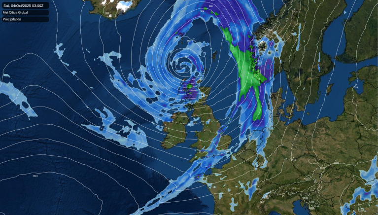
Tucked around the centre of the low will be a host of heavy showers and more persistent rain from the wrap-around occlusion drenching Scotland from the west and northwest and sinking southwards to Northern Ireland and Dumfries & Galloway by daybreak on Saturday.
Also showing as a bright line on the UKV model is the cold front with signs of active line convection. Around midnight, you can see it stretched from The Wash to Dorset and this will move southwards over London and the Home Counties. You may hear sudden heavy rain or gusty winds as it passes by.
A band of heavy rain will move down over NW England to north Wales and the Peak District on Saturday morning. Heavy showers will follow in the strong winds from the northwest
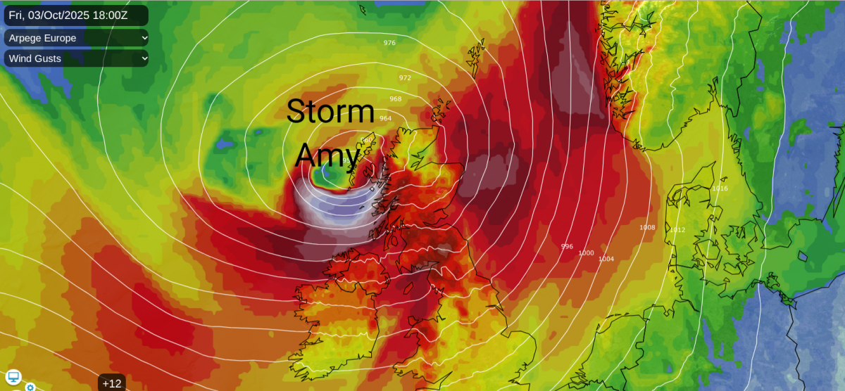
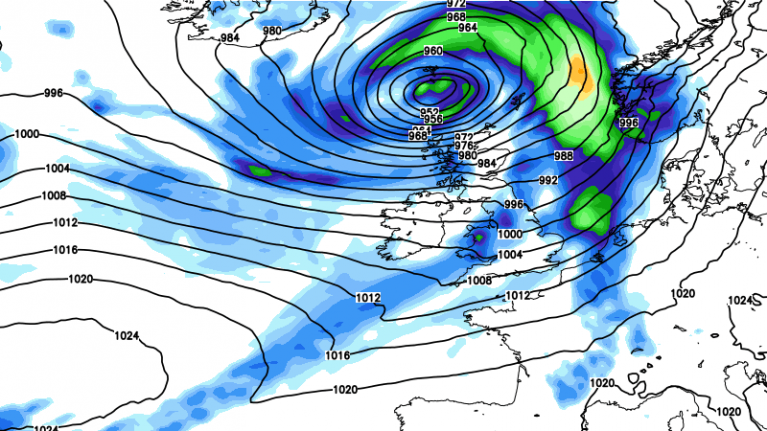
There is still uncertainty about the exact timings (such as for the line convection band), the depth of the low and where exactly will see the most intense core of strongest winds. Storm Amy is moving from one side of the jetstream to a more developmental area. It will then rapidly deepen. The forecast shows it moving over the far northwest of Scotland and be centred over the Northern Isles on Saturday, bringing a windy day across the UK.

From the Met Office synoptic charts, the drop in central pressure in 18 hours could be 32mb from 978 to 946hPa Friday pm. This is a significant low pressure and it is lucky that most of the severe weather will be overnight. Hopefully, some people in the north and west of the UK will be able to adjust their plans for travelling later on Friday, as conditions will be grim.
Sea conditions
Northern Ireland will bear the brunt of the gales during Friday afternoon and early evening. The intense core of high gusts could brush the north coast before it impacts the Western Isles and west coast of Scotland. The Inshore Waters forecast includes “Wind SE 7 to severe gale 9, veering SW then NW later, severe gale 9 to violent storm 11. Sea state Moderate or rough, becoming very rough or high.”
The Irish Sea will see severe gales with disruption possible to ferry services, including early sailings. Coastal areas will see deteriorating stormy conditions and large waves in the southwesterly gales.

Winds
Everywhere will notice the winds picking up later on Friday. The main focus has to be the far northwest as Storm Amy comes close to western Scotland. The setup could produce a sting jet and there is the possibility of low level gusts reaching 100mph. Conditions will be wild at height, it is not a night to be up the Scottish mountains.
There is more agreement now in the models about the wind core slamming into western Scotland during Friday evening but the amber wind warning over Northern Ireland covers only medium confidence around the zone of highest winds. And there is the upgrade from Met Eireann to a red wind warning for County Donegal.

Ahead of the low there will be strong to gale force S or SE winds for Grampian and the Northern Isles this evening. The centre of the low should move right across Lewis and this will bring a spell of calm as the storm rages around about. As Amy moves to the north coast of Scotland, land gales around the southern flank will continue with gusts over 80mph. For the coasts and mountains there will be severe gales through the night, perhaps reaching storm force for northern mainland Scotland and Orkney. The southwesterly winds will veer to the northwest after midnight.

This wind veer will accompany an occlusion southwards, the band of rain for Saturday morning. Westerly gales from the Irish Sea will run straight at Morecambe Bay and Merseyside. A colder NW flow will continue for the far north of Scotland with severe gales reaching over Orkney, Caithness, and to the Moray coast.
There is a Met Office yellow warning for wind through Saturday and it will be a windy day.
“...gusts of 45-55 mph possible in places, and perhaps 60-65 mph along some exposed coasts, especially in the west, and briefly over more exposed hills inland”
Local disruption is likely as businesses and organisations make their own decisions about this windy, autumn weather. Although the winds will ease from SW Britain during Saturday night, it will take until Sunday morning for the gales to subside in NE Scotland and for Amy to move off to Norway.
More discussion and chat about Storm Amy in the Netweather forum
Loading recent activity...