The first named storm of the season will arrive later on Friday. There are stong winds and heavy rain in the forecast for the end of the working week and Saturday looks windy across the UK. The weather will improve later on Saturday for southern Britain and there will be a fine start for many by Sunday morning.
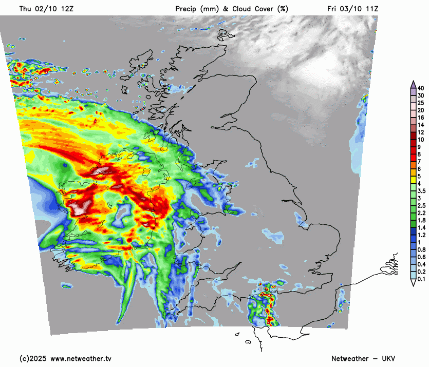
However, Storm Amy will bring wild conditions on Friday evening and Friday night. This event starts with a band of heavy rain reaching Northern Ireland in the afternoon. As the strong winds and gales set in for Friday evening, northern Britain will see a band of rain move by, particularly heavy in the northwest.
“Storm Amy will bring a spell of damaging winds on Friday evening and night, gradually easing through Saturday… wind gusts of 60-70 mph are likely fairly widely, and may exceed 95 mph in more exposed areas. This is likely to lead to travel and power disruption.” Amber wind warning for Scotland MO
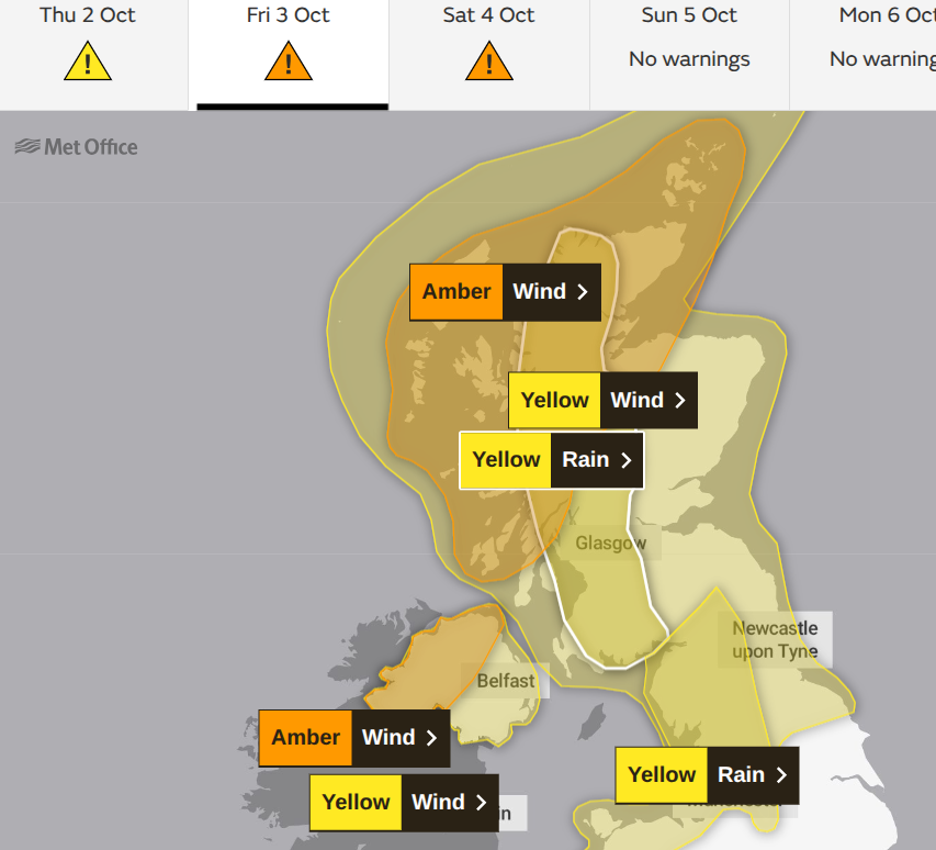
"Storm Amy will bring a spell of damaging winds on Friday late afternoon and evening, perhaps causing some disruption... up to 80 mph along some more exposed coasts." Amber warning for Northern Ireland
The core of strongest gusts and severe gales looks to be focused on NW Scotland including the Western Isles on Friday evening before moving to northeast Scotland, including the Northern Isles, before dawn. There are flooding concerns for western and central Scotland, northwest England and Wales. At the other end of the UK, those in London or the Home Counties will witness increasing winds overnight and there will be narrow, vicious bands of intense rain moving southeastwards over England. These might wake you during Friday night or still be over the far southeast of England for those heading out around daybreak on Saturday.
Wide warm frontal band of rain Friday pm followed by a narrow but intense cold front in the early hours of Saturday.
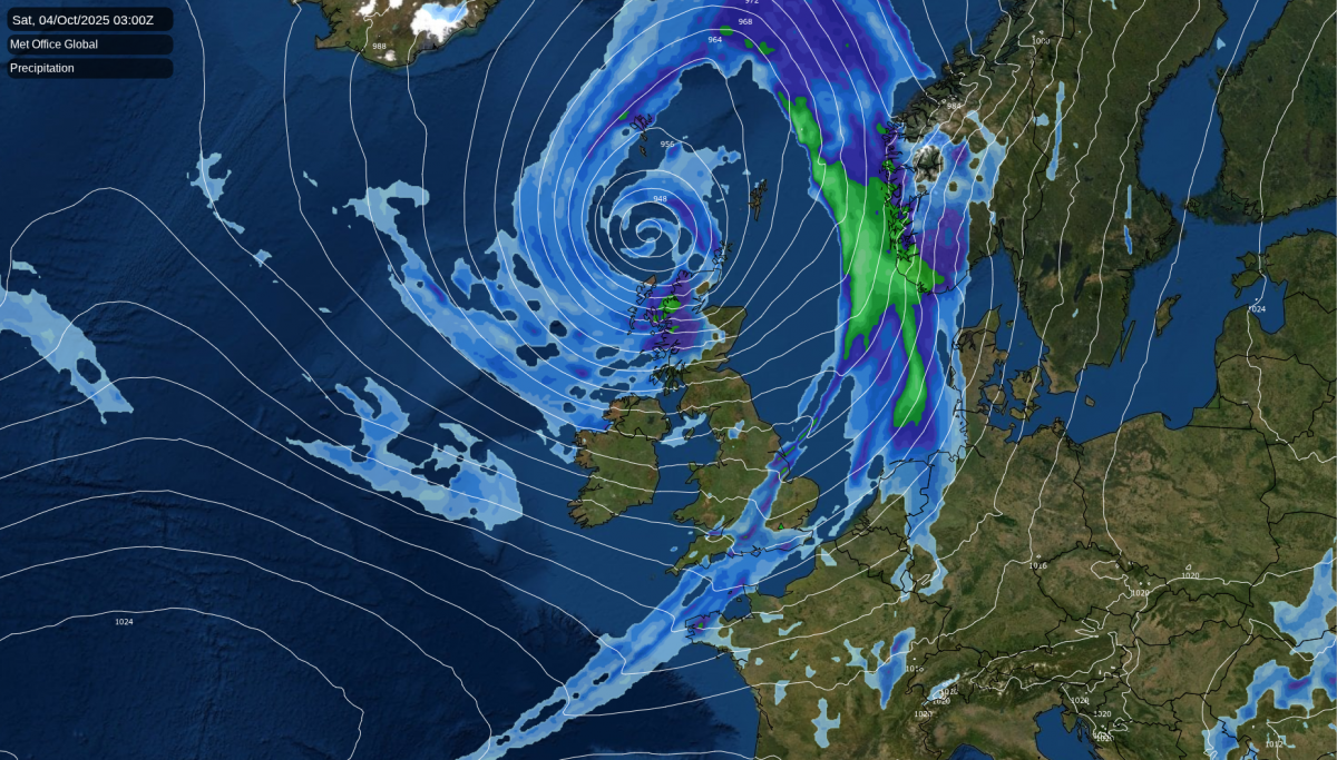
On Saturday, the worst of the storm will continue to rage in the far north, and finally clear away from the Northern Isles on Saturday evening as the centre of the low heads away to western Norway.
What to expect?
Remember, the Met Office warning system is about likelihood and impacts. The Met Office warning matrix has a "low likelihood and a high impact" marked for the Amber warned area. High impacts from winds could include - "Widespread danger to life from flying debris and widespread structural damage. Transport routes and travel services could be affected for a prolonged period. Widespread and prolonged disruption to power."
The storm has been named to highlight an upcoming severe weather event. The stormiest weather will be over Scotland. The northwest Highlands are more used to gales and heavy rain than in central London, but this is still a fierce-looking low pressure and most of the UK will notice its windy presence by Saturday.

Western Scotland will have already seen heavy rain this week by the time Amy arrives. On Thursday, there was a yellow rain warning from a different low pressure (Low 1), which will bring wet and blustery weather across the UK during Thursday night.
With more heavy rain and strong winds from Amy, travel disruption seems very likely for western and northern Scotland. To ferry and rail services along with the risk of landslides and road disruption. Also restrictions or closures on bridges or causeways. There is the risk of power outages. Preparations should be complete before dark on Friday, and adjustments to travel plans should be underway now for those in Scotland, particularly Islanders, and also for Irish Sea journeys.
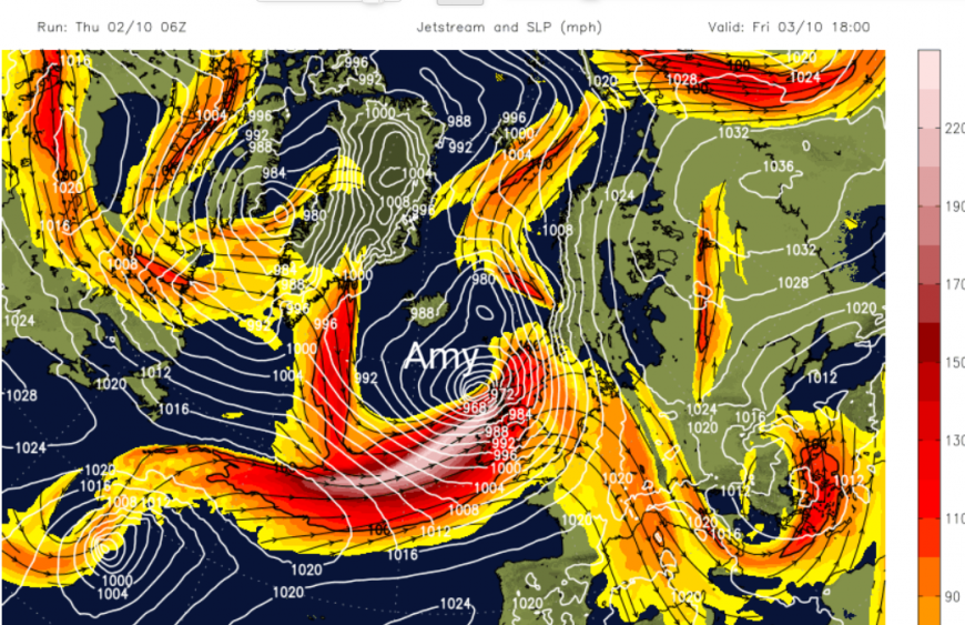
Storm Amy will undergo explosive cyclogenesis as it moves from the southern side of the jet stream to the right entrance development region. Cyclogenesis is the usual process of a low pressure forming, a cyclone being created. There is Rapid cyclogenesis, and then Explosive cyclogenesis (sometimes unofficially called a weather-bomb) when a low’s central pressure falls 24mb (hPa) in 24 hours.
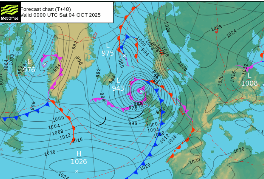
Met. Office synoptic chart showing central pressure of 943hPa by Saturday 00Z
This will be a significant low pressure tracking to the northwest of the UK. During Friday night, a core of intense winds will catch the far northwest of Scotland, where there is an amber warning and gusts over 90mph are possible. There will be severe gales, even storm force winds.
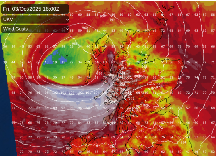
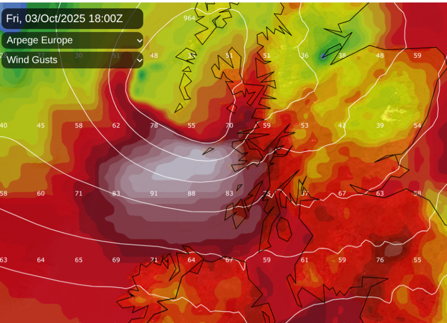
Friday evening sees southerly winds, southeasterly for Grampian and Orkney but veering to the southwest as the intense core gets closer. There are still shifts in each model run, with where the core of strongest winds and highest gusts will hit and the timing, Friday evening or midnight? Above is a later run from Thursday and below an earlier UKV run. The new Amber warning for Northern Ireland joins orange wind warnings for northwestern counties of Ireland and red marine storm warnings all along the coast of the north and northwest. The UKV Model is now showing the intense wind core close to Co. Donegal at teatime then the Western Isles durign Friday evening.
Intense wind gusts showing for western Scotland on Friday evening
The southwesterly winds and gales rage through the night and begin to veer to a westerly by dawn. Many trees are still in leaf as this is only early October, so with large surface area they can be impacted more by the strong winds. The far north of Scotland will be battered by northwesterly gales during Saturday as much of the UK remains in a fresh to strong westerly. The winds will drop by Saturday evening for southern counties of England and south Wales but for the Northern Isles the gales continue with gusts still over 80mph.

If Storm Amy is a bit further south as shown in the 12z UKV model then Shetland will be calmer conditions for part of Saturday near the centre of the low pressure as Orkney, Lewis and north mainland Scotland (and north Wales) remain exposed.
As the cold front rain and line convection clear Kent on Saturday morning, there will be plenty of sunshine for England and Wales. The westerly winds will bring a scattering of showers over northern England (although more shelter in the northeast) and showers for Wales, particularly in the north. Northern Ireland and Scotland will see a host of heavy showers whizzing by on the strong winds and just generally wet weather for the NW Highlands. There will be a lot of surface water and the continued risk of flooding and disruption in the far north.
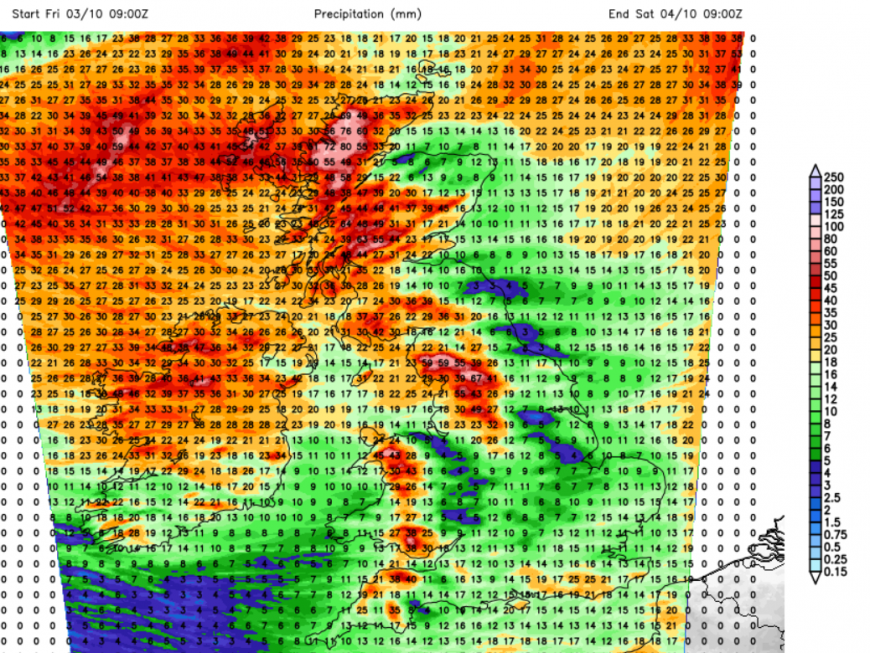
24 hour rainfall totals from UKV model Friday into Saturday morning
Caught up in Storm Amy will be some warm air, thanks to its links back to tropical systems in the western Atlantic. If you are not in the heavy rain, you will notice how mild Friday evening feels. Southern Britain will have a warm end to the working week. Behind the lively cold front there will be a tuck of cooler air from the west. Adding on the wind, Saturday will feel fresher, even a bit nippy. Colder air will be pulled down from the northwest for the start of Sunda,y so even though there may be sunshine and lighter winds, the air won’t be as mild.
More discussion and chat about Storm Amy
Loading recent activity...