A deepening low pressure will head close to Scotland for the start of the weekend as two Atlantic hurricanes lurk close to Bermuda. Wild and wet conditions later on Friday if you have UK travel plans.
It’s autumn, and we would expect wet and windy weather, mixed with bright or sunny days, but also the appearance of fog and frost. This weekend it will be a windy theme for the first half and especially in the north. A deep low pressure is forecast to move past northern Scotland, bringing wild conditions to some parts of the UK during Friday night after a warm-up spell of blustery wet weather later on Thursday. The Thursday night wind and rain is not the main low of this week. There is more to come.

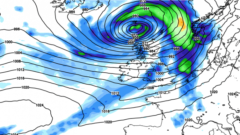
By Friday lunchtime, frontal rain will be over Ireland. Conditions will deteriorate for Northern Ireland, around the Irish Sea, and for western Scotland with heavy rain, followed by strengthening southerly then southeasterly winds. There will have been plenty of rain for western Scotland already this week and flooding is likely with a risk of travel disruption for the busy Friday evening commute. Ferry services are also likely to be impacted. Stormy weather looks increasingly likely for Friday evening and overnight as this deepening low moves by. Gales, even severe gales accompanied by lashing rain and surface water issues. The storm looks to rage through the night for the far north of Scotland, particularly the Western Isles and Northern Isles. The stormy conditions could last through Saturday for Shetland and Orkney in a more westerly flow.

There has been uncertainty around the forecast and where the deepening low pressure would end up. Even overnight, there has been a shift to keep the low slightly further north, with the worst impacts for the northwestern third of the UK.

It all links back to the other side of the Atlantic, where two hurricanes (Humberto and Imelda) have been interacting. Where one deep autumnal (extra tropical) low pressure would end up would be enough to keep an eye on. One tropical cyclone in the Atlantic lowers the confidence in how the models can respond but two!

In 1921, Sakuhei Fujiwhara, of the Central Meteorological Observatory of Tokyo, published an article on theoretical considerations of the interactions of a vortex in a fluid, in particular between two vortices. He described how, when two vortices approached each other, they would tend to orbit around a common centre point. This interaction came to be known as the “Fujiwhara Effect”.

It looks like Humberto will be overcome by Imelda but manage to spawn a new low ahead, which will head northeast towards the UK for the end of the week. Caught up by the jetstream and as it moves into an area of development, this new low will deepen. That is quite a lot going on and so currently there is not a named storm (it would be Amy) and the thinking is that this low will not be ex-Humberto but will have benefited from a lot of tropical energy and moisture.

If you do have travel plans for Friday evening, keep an eye on the forecast. Even for southern Britain as flights around the UK can rely on an incoming plane from one part of the UK to get to somewhere else. This is the time of year to make sure you have signed up for flood alerts and western Britain will see some heavy rain in the next week.
More chat in the Netweather forum
Loading recent activity...