The low pressure remnants of ex-Hurricane Garbriel could bring flooding to the Valencia region, the areas hit by catastrophic flooding less than a year ago. Also, ex-Hurricane Herberto looks to head towards the UK by next weekend, bringing a risk of severe gales and heavy rain.
The remnants of two different hurricanes look to bring some adverse weather conditions to different parts of Europe this week.
The low pressure remnants of Hurricane Gabrielle slowly drift towards eastern Spain to start this week, drawing in and creating lift of warm and humid air off the Mediterranean along eastern coastal areas of Spain - leading to persistent heavy rainfall with a risk of flooding.
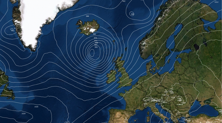
Meanwhile, major hurricane Humberto, which looks to track north between the Bahamas and Bermuda early this week, looks to eventually accelerate northeast across the North Atlantic, becoming post tropical, but deepening again later in the week and passing to the north or over Scotland by early Saturday, bringing severe gales, rough seas and heavy rain across the UK and Ireland Friday and into Saturday.
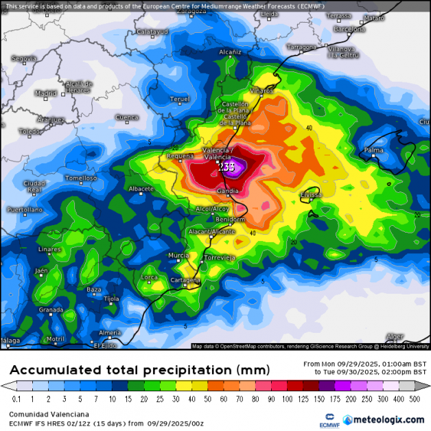
Looking at eastern Spain first, the remnant low of ex-Hurricane Gabrielle, which crossed the Azores last week bringing hurricane force winds, has drifted southeast over Iberia over the weekend, losing its intensity. However, the low-pressure core remains over southern Iberian Peninsula into early this week, which together with high pressure to the north, is pulling in a warm and moist easterly flow over the Mediterranean coast. This, combined with cool air aloft associated with high-altitude trough accompanying the surface low, is resulting in large amounts of instability leading to very heavy and persistent rainfall in the eastern third of the Iberian Peninsula and the Balearic Islands that started on Sunday and will last until Tuesday evening.
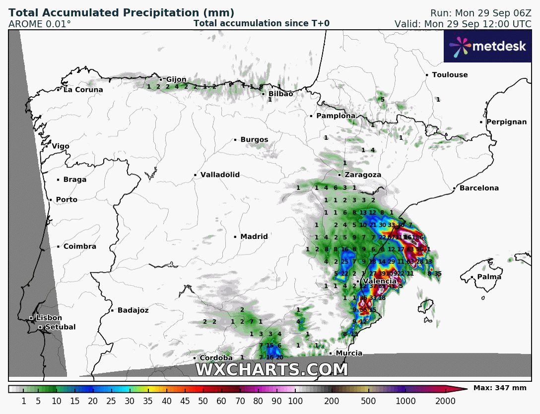
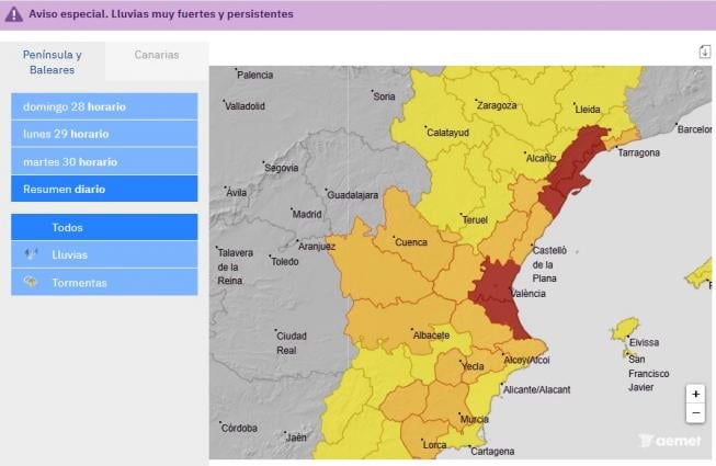
The heavy rainfall may cause sudden local flooding in low-lying areas, streams, and gullies, so the potential danger level of this situation is high. The Spanish Met service AEMET have issued red extreme rain warnings for Castellón & Valencia areas for today and tomorrow, for 180mm falling in 12 hours.
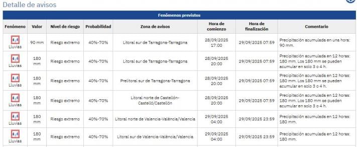
Today and tomorrow will likely see the highest risk of flooding from this event. From early this morning there has already been locally strong to very strong and persistent thunderstorms affecting the Valencian area and up into Castellón, these storms will spread to other inland areas of the southeast during the afternoon. The greatest intensities and highest accumulations are expected in the centre and south of the Valencian area, and especially in the province of Valencia, between Monday and the first half of Tuesday, when torrential rainfall could exceed 250-300 mm.
Only last year, in late October 2024, Spain experienced one of its deadliest floods in decades in the Valencia region and nearby areas suffering devastating impacts. Over 200 lives were tragically lost, thousands were displaced, and the destruction of infrastructure and livelihoods was extensive. Over 400 litres per square metre fell in just 8 hours in one part of the Valencia region. The intense rain was attributed to a phenomenon known as the ‘gota fría’, or “cold drop”, which occurs when cold air moves over the warm waters of the Mediterranean Sea creating large amounts of instability. This allows warm, moist air to rise rapidly to form towering, dense clouds capable of dumping very heavy rain.
Looking at the next ex-Hurricane looking increasingly likely to affect European weather, this time northwest Europe at the end of this week, Humberto is currently a major Category 4 hurricane with sustained winds of 130mph, looks to eventually head towards Scotland later in the week. The hurricane will turn north between the Bahamas and Bermuda over the next few days, producing dangerous surf for Bermuda and the U.S. East Coast over the next few days, will turn northeast north of Bermuda on Wednesday. Humberto will then likely become extratropical on Thursday, as it’s picked up by the upper westerlies around the far North Atlantic upper trough, then the extratropical low accelerates northeast under an increasingly strong jet stream, fuelled by the latent heat release along the thermal boundary from tropical air wrapped up in the ex-hurricane.
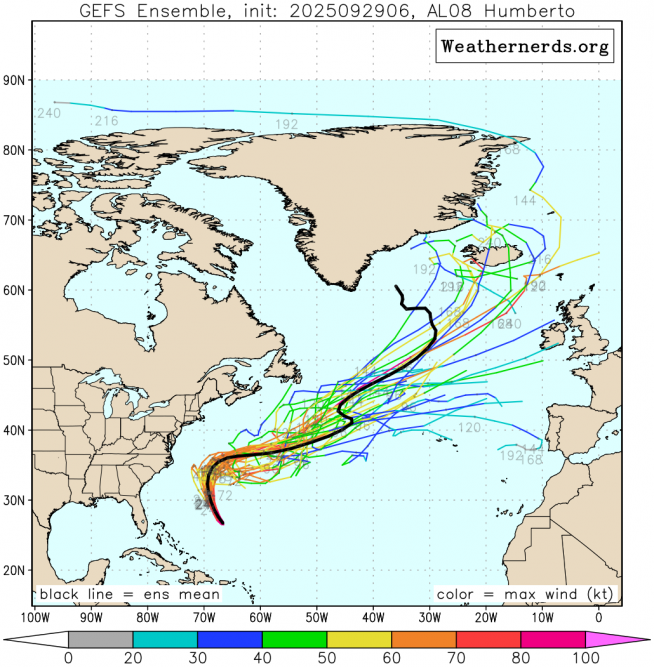
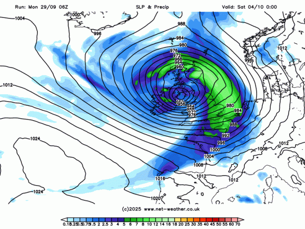
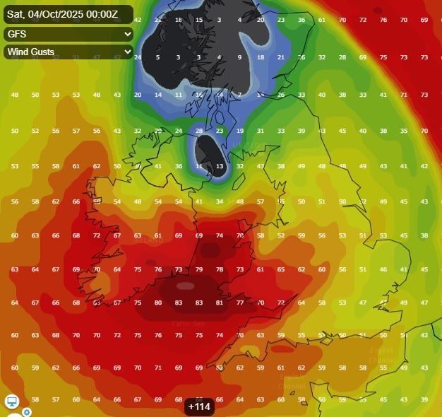
The ex-Humberto remnant low may then deepen rapidly under the jet stream - tracking northeast towards Scotland. However, there is a lot of uncertainty this far out on the track. The operational / deterministic runs vary in track. 00z ECMWF takes the low north of Scotland, while UKMO takes the low northeast over Scotland. 06z GFS takes the low further south still over Ireland and northern England, with gusts of 70-80mph over southern Ireland, the Celtic Sea and west Wales early Saturday. Gales developing elsewhere too. Potential this could be the first named-storm of the 2025-26 season. Likely warnings will be issued at least during the week when the track is firmed up on.
Likely the end of the week will be very different to how the week started!
Loading recent activity...