There is a theme of rising temperatures through the weekend and talk of another heatwave by next week. Before that, we have an unsettled, mixed Thursday followed by a fine Friday, away from the far north of Scotland.
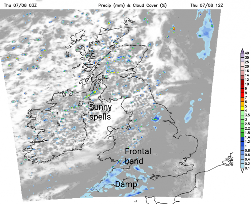
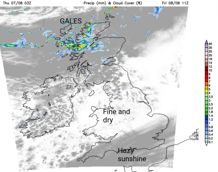
During Wednesday night, a frontal band moved in from the Atlantic. There is a good deal of cloud about for Thursday morning in the west to southwesterly flow but to the lee of high ground, there are clearer breaks and sunshine for eastern Britain. The frontal band will continue to weaken as it moves from northwest England and western Wales. There will be showery outbreaks of rain for the Midlands and continued damp and grey weather for southwest Britain. However, in the breezy conditions, breaks will appear in the cloud cover, allowing brighter, even sunnier spells to come and go over England. To the northwest of the frontal band, where the wind has veered to a more westerly flow, the cloud cover will break up, resulting in more sunshine. Rather than the blanket of cloud, there will be a mix of showers from the north west, broken cloud cover and sunny spells.
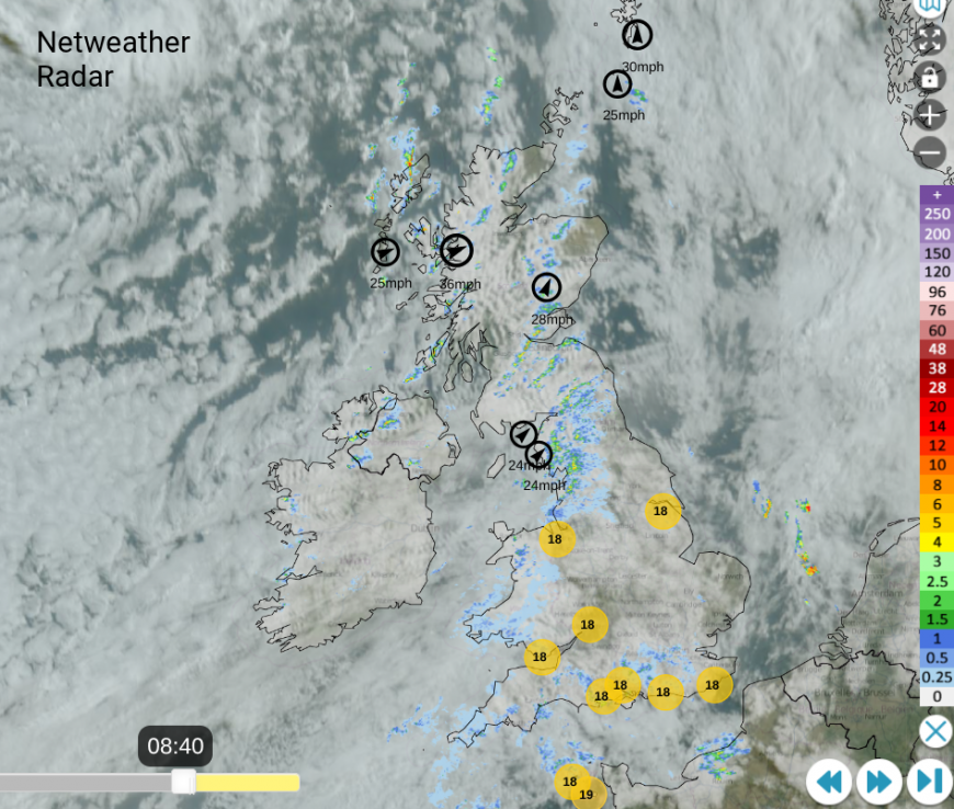
The frontal band brings a slow start for Wales with grey skies and damp weather but there will be an improvement from the north. The frontal band should be away from South Wales this afternoon, allowing the brighter skies and some sunshine but there is some disagreement with the weather models about the timing of the clearance from Cardiff and the Bristol Channel area. The UKV model has the front cleared early afternoon and a fine afternoon. Others, such as the ECM European model, keep the grey, damp weather lingering until teatime.
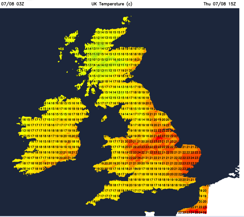
Temperatures will vary, from 18C to potentially 22C if the sun appears. North Wales could do well to the lee of high ground and more sunshine, perhaps up to 23C
For England, there is a similar division as the frontal band moves through. To the northwest of the band, there will be sunny spells, a few showers but a definite brightening for those who saw a grey start. There could be some sharp downpours for Yorkshire, towards the Humber and over the North Yorkshire Moors if the temperatures respond in any sunshine. Whitby and Scarborough could reach 21C and it will feel warm.
Depending on where does see sunshine for central, southern and eastern England, the temperatures range from 18 to 24C, so it could be a fine, warm day in the blustery southwesterly wind. The West Country will take longer to lose the frontal cloud today, maybe into Thursday evening. With the onshore wind, tomorrow afternoon looks better for SW England. Temperatures will still be around 19 or 20C.
Grampian will see a good deal of sunshine but the west coast of Scotland will see ongoing showers passing through. Temperatures in sunny Aberdeen should reach 22C with 18C for Edinburgh and Glasgow. As the low centre passes by, there will be gales for the far north of Scotland and the Islands.
Northern Ireland will see a peppering of showers during the day, mixed with bright and sunny spells. The showers will ease from the northwest during the afternoon as Belfast sees 20C with 17C for the north coast.
Tonight, the frontal band will move across the Channel and fade over northern France as high pressure begins to build in. Northern Scotland continues to be troubled by passing low pressures and weather fronts. It keeps the weather windy and unsettled here as a new rainband reaches the Highlands and Islands for Friday morning. Again, there will be gales for the Minch.
Friday
The northern half of the UK will have a blustery start on Friday with a few showers caught on the wind, coming into Morecambe Bay as the main area of windy and showery weather continues for northern Scotland. Elsewhere, there will be a lot of fine, dry and sunny weather on Friday with only light winds for southern Britain.
For temperatures to rise, it is the sunshine that really helps. A steady setup, under high pressure, keeps the air still and so the incoming solar radiation heats the ground and that continues to heat the same air mass above it. Windy days just move the air about, which is when people can get caught out and sunburnt as they don’t realise. A warmer airmass, such as a southerly flow from Spain and France, can enhance the heat for the UK, which is what will change as we go into the start of next week. Southern Europe has seen heat this week, with many warnings.
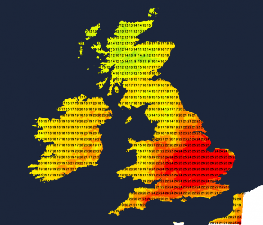
For now, temperatures are peaking in the low to mid 20s C, perhaps up to 27C for a few spots on Friday. Friday night looks cooler before heavy rain arrives for northwestern Scotland from yet another frontal band. Elsewhere, there will be more dry weather as the temperatures start to climb at the weekend.
Loading recent activity...