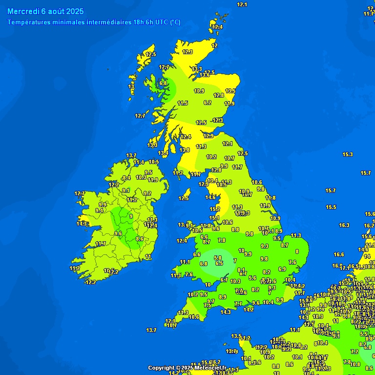
Last night turned quite chilly across rural areas of England and Wales, thanks to the Polar maritime airmass across the UK. Temperatures widely fell into single digits in rural areas, as low as 5.6C at Benson in Oxfordshire, 5.8C at Shobdon in Herefordshire.
It will be warmer tonight and, although temperatures will be around the average for the time of year over the next few days, it looks set to get warmer and more humid by day and night from the weekend and into early next week.
High pressure will build in from the southwest over the weekend, eventually reaching Scotland on Sunday, bringing drier and sunnier conditions, away from the far north. Temperatures reaching 27C in London on Sunday, 25C in Cardiff, low 20s further north.
Very warm air pulled north across southern UK early next week could lead to a heatwave here
Eventually high pressure will migrate to east of the UK by the middle of next week. This combined with an upper trough and low pressure moving in to the west will serve to potentially pull in some very warm and humid air from the south off a hot near continent next week - with some models, such as GFS and ECMWF over the last few runs, showing temperatures reaching the low 30s degrees Celsius from Tuesday across the south and east of England. 00z ECMWF has 32C across eastern England on Tuesday
00z ECMWF showed temperatures reaching the low 30s across eastern England on Tuesday
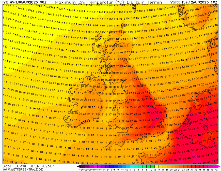
How long the heat here lasts is uncertain, ECWMF has temperatures drop back on Wednesday and Thursday, 26-28C confined to SE England, as cooler air spreads from the west, though does return a 30C across the London area Friday. GFS has 30C is a small area confined to the far south of England south of London Wednesday and Thursday. Obviously, over 7 days away, too far out to take temperature forecasts with any confidence.
But can we say a ‘heatwave’ is on the way based on current model runs? There are official set criteria for defining a heatwave in the U.K.
"A UK Heatwave Threshold is met when a location records a period of at least 3 consecutive days with daily maximum temperatures meeting or exceeding a Heatwave Temperature Threshold" Met Office
The Met Office heatwave thresholds were updated in 2022 for the 1991-2020 period, with eight counties in England now sitting at a higher level to reach heatwave criteria. So, now, six more areas in England are in the >28C threshold to meet heatwave criteria, while Lincolnshire has moved to the 27C threshold and the East Riding of Yorkshire, the 26C threshold. This reflects the warming of average temperatures since the previous 1981-2010 period - due to climate change.
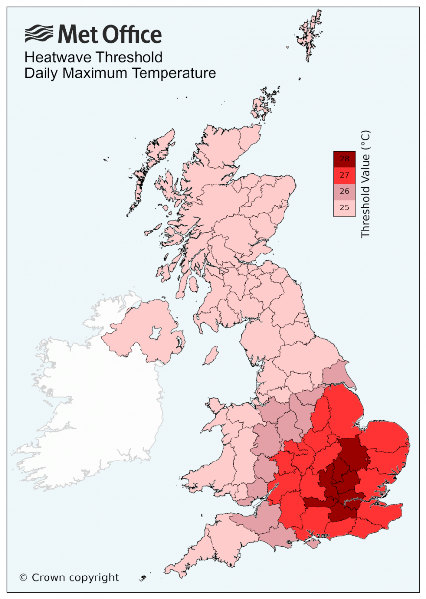
It looks possible, rather than likely, at the moment, that parts of southern and eastern England will reach heatwave criteria from Tuesday based on current model runs - reaching 27 or 28C or more for three days or more. 00z ECMWF high resolution run brings 31-32C on Tuesday, from the London area up to Lincolnshire & across East Anglia. Temperatures back down a bit Wednesday & Thursday, but still high 20s Celsius in SE England / East Anglia - this meets the >28C #heatwave threshold of 3 days or more in these parts. GFS not as hot Tuesday, but has high 20s to low 30s across central, southern and eastern England from Wednesday to Friday. So again meeting heatwave criteria for these areas.
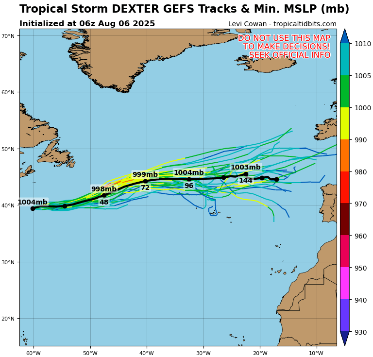
However, there is a fair bit of uncertainty from the models on the synoptic evolution as early as the start of next week, thanks to Tropical Storm Dexter, which will become ex-tropical in the next few days, bringing more uncertainty to modelling - due to uncertainty over how quickly the storm will weaken and also it’s track across the North Atlantic. Of the latest operational runs, UKMO & ECMWF bring the remnants of ex-tropical Dexter towards the UK early next week as a decaying feature but disagree on how quickly, while GFS keeps the low near the Azores instead.
But looks possible the heatwave threshold, as determined by the Met Office, will be met from Tuesday or Wednesday next week across parts of southern and eastern England, as it stands from viewing the model output today.
Loading recent activity...