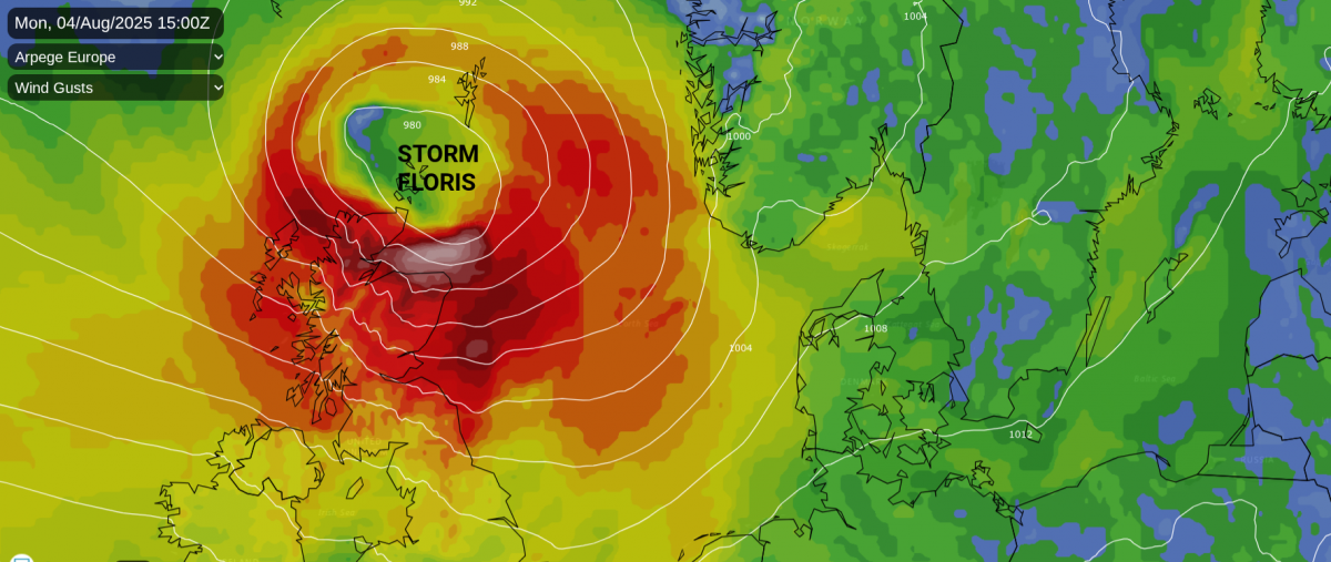
Storm Floris has certainly impacted Scotland with wild conditions; heavy rain and severe gales. It has been an exceptional event, most unusual for this time of year, reaching over more of northern Britain, Northern Ireland and the Republic of Ireland on Monday.
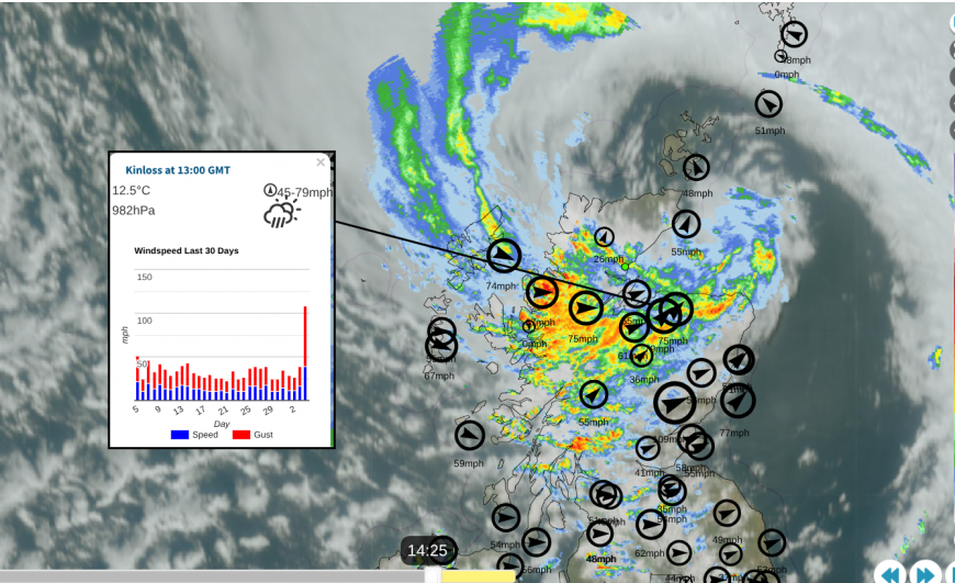
There have been low-level gusts of 79mph reported in Moray and on the Western Isles, as well as the mountain site Cairnwell showing a gust of 109mph not far from the Glenshee ski centre in the Eastern Highlands. Much of northern and central mainland Scotland has been covered by an amber wind warning, with a wider yellow warning covering Northern Ireland and more of northern Britain.
Orkney has been added to the amber warning, which lasts until 11pm on Monday as the low pressure begins to pull away over the North Sea. There is also an extension yellow warning for the Northern Isles into Tuesday morning for “High winds, as Storm Floris clears, may bring disruption to travel” as the stormy weather moves away from Shetland towards Scandinavia.
Train services across Scotland had been severely disrupted. The list of cancellations on the Scotrail website is very long, with other operators such as LNER, Cross Country, Avanti West Coast and even the Caledonian Sleeper being affected on Monday 4th August.
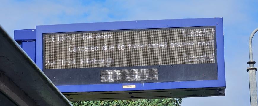
Scotrail has reported numerous fallen trees onto tracks and onto overhead wires, showing that the slowing or cancellations of services were a wise precaution.
The London-Edinburgh-London cycle ride is being held at control points due to the high winds, as the riders move from northern England into southern Scotland. “We will keep the pause in place for at least another four hours and will update you all again at 1930.” #LEL2025
Bridges in northern Britain have seen restrictions to high-sided vehicles, as has the A628, which is a high-level Pennine route between Yorkshire and Manchester. Ferry services to the Scottish Islands have been disrupted and there have been cancellations to some flights, mostly between Britain and Ireland. Bus services in northern Scotland have been impacted with Highland Council reporting many trees down across Nairn, Lochaber and the Black Isle.
Scottish and Southern Electricity Networks “This relatively rare summer storm is bringing sustained storm-force winds to most of our north of Scotland network area…We're responding to damage on our network caused by Storm Floris’ extremely high winds, with particular impact in the Highlands, Moray, and in Aberdeenshire.”
The worst of the storm will continue to rage over northern mainland Scotland into the evening. There have been power outages for homes and businesses in parts of Scotland and Northern Ireland.
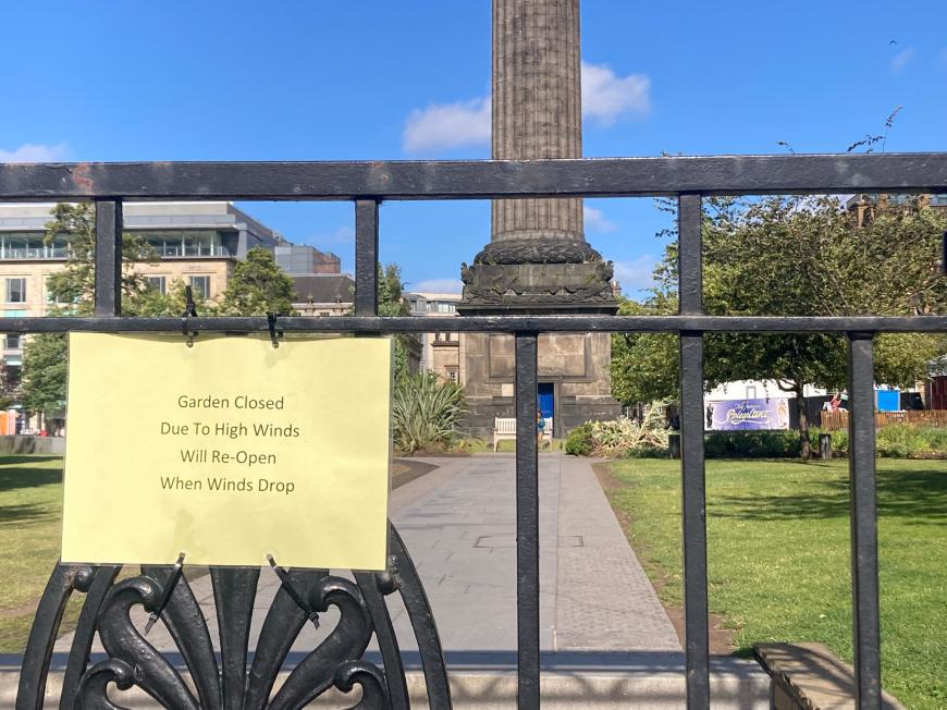
The Edinburgh Fringe has only just started and some venues have had to close today due to the wild conditions in the more populated Central Belt. With train services severely reduced, it has not been ideal for travellers from outside of the capital. The Edinburgh Tattoo has also been cancelled due to bad weather, the first time in its history.
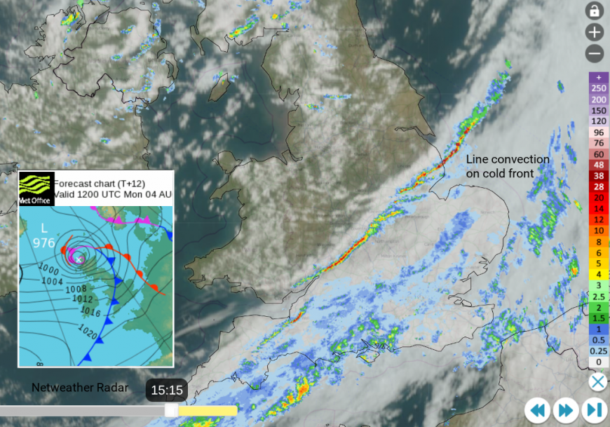
Although southern Britain has escaped the wild and windy conditions of Storm Floris, the cold front is continuing its progress southwards across Britain. Along this boundary line, there is line convection which will bring sudden heavy downpours with very gusty winds and tricky conditions on the roads for a short while. This line from The Wash to the Bristol Channel is well defined and worth watching into the early evening rush hour.
There have been warnings to holiday makers to take extra care with trailers, caravans, tent boxes even roof boxes in the high winds and maybe just staying still for today as some vehicles or trailers have overturned.
The amount of fallen trees in northern mainland Scotland has been significant as the winds battle the full leaf cover. There has also been heavy rain, from the main frontal bands but also around the occluded front over the far north.

The storm will continue to move over the Northern Isles with a lull in the low centre. The Inshore Waters forecast for Orkney and the Moray Firth “Wind- Cyclonic becoming westerly, gale 8 to storm 10, occasionally violent storm 11 at first in south, decreasing 6 to gale 8 later” as severe gales pick up for Shetland tonight. There is ongoing ferry service disruption to the Northern Isles and flight cancellations at Aberdeen Airport.
Through Monday night, the stormy weather will slowly ease down from the Northern Isles and the Moray Firth with a NW/W flow. There will still be strong westerly winds over the Pennines, whistling across the Irish Sea and still over Scotland. It will be cool overnight. Storm Floris will impact other parts of Europe with amber wind warnings for SW Norway and NW Germany with wider yellow warnings.
Tuesday will be a blustery day, but not stormy like Monday. There will be plenty of sunshine about with a scattering of showers for the northern half of Britain in northwesterly winds. For southern Britain, temperatures will reach into the low 20sC so feeling pleasant in sheltered sunny spots.
More chat online in the Storm Floris thread
Loading recent activity...