Storm Floris will impact northern parts of the UK, particularly Scotland, on Monday 4th August. Summer storms are unusual but not unheard of here in the UK. The naming of storms by the UK Met Office, Irish Met Éireann or Dutch KNMI is a communication tool to raise awareness of upcoming severe weather.
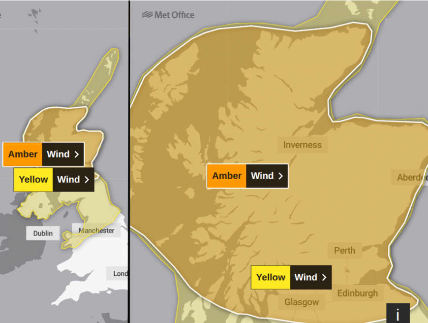
AMBER “Storm Floris will bring unseasonably strong and disruptive winds to much of Scotland during Monday.” Met Office 10am Monday 4th August
There has been some glorious, warm and sunny weather this weekend. The dramatic change, to wild conditions more like autumn, warrants attention, especially as people may be away enjoying their summer holidays, camping or visiting unfamiliar places. Ferry services and events in Scotland are already being cancelled in preparation. It is also a public holiday on Monday in the Republic of Ireland.
“Wet and unseasonably windy weather expected. A greater number of people will be exposed to these weather conditions due to large number of outdoor events, camping, etc “ Met Eireann
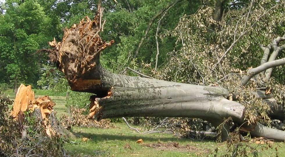
All this whilst the trees are in full leaf. It has also been very dry, with the warmest and sunniest spring on record for the UK. The very dry conditions might mean that root systems are not as strong as usual.
A bout of very strong, potentially exceptionally strong, winds needs to be highlighted to the public, local authorities and organisers of events for the start of the new working week.
There is a wider yellow wind warning over Northern Ireland, the Northern Isles, the southern counties of Scotland, Northern England, into north Wales.
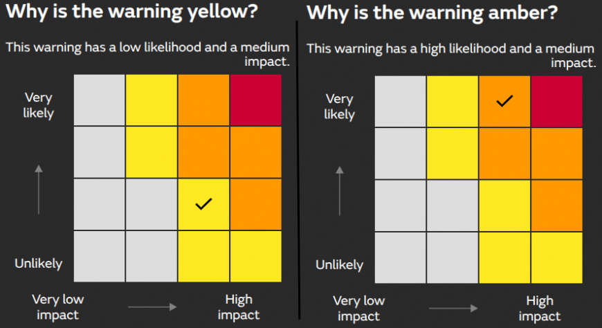
Both these warnings highlight medium impacts, it is just that they are more likely within the amber-warned area, “very likely”. Within the yellow-warned area, there is a low likelihood of the same impacts, but still enough of a risk for a warning of severe weather to be issued.
YELLOW 6am “Storm Floris is likely to bring a spell of unseasonably strong and potentially disruptive winds to northern UK on Monday.”
Storm Floris will be the sixth named storm of this current season, which runs from September. The last named storm was Eowyn back in late January, so it has been a while. Back in August 2024, Storm Lilian disrupted the Leeds Festival with high winds and heavy rain. Not as severe, but they were the only named storms of the 2022/23 season. Antoni and Betty occurred in August 2023. Storm Evert in July 2021 impacted campers in Cornwall but it was back in August 2020 when Storms Ellen and Francis brought damage and disruption with power cuts and landslides. These storms developed in a time of a strong, summer jetstream.
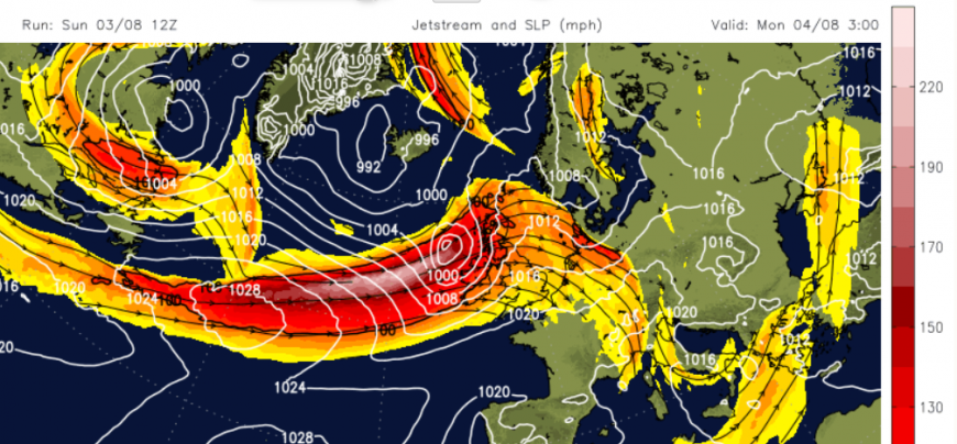
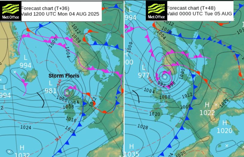
For August 2025 there is also a strong Atlantic jet. The low centre will move to cold side of the jet, which puts Floris in an area of development, the left exit of the jet, early on Monday morning and it will then rapidly deepen. Storm Floris will bring stormy conditions across northern parts of the UK before heading away over the North Sea to Scandinavia on Tuesday.
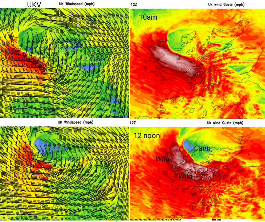
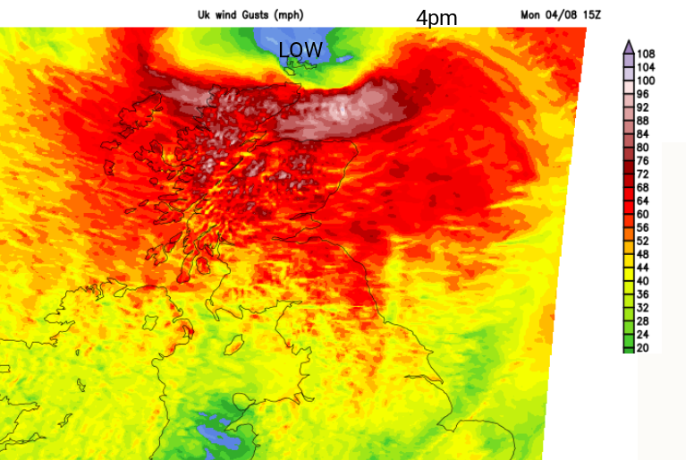
The Met Office highlight “a spell of unusually strong west or northwesterly winds to much of Scotland during Monday” focused within the amber warning. There will be gale, severe gale even storm force winds. Also, gusts are expected of 50 to perhaps 90mph for exposed areas; there is the risk of disruption to travel over bridges and dangerous conditions along coasts and over high ground.
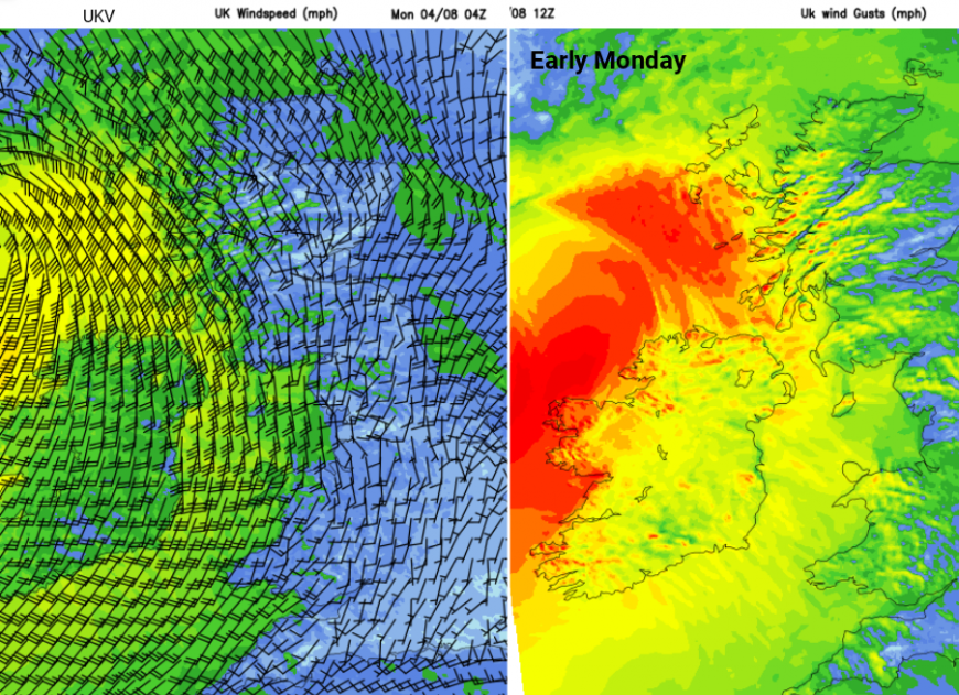
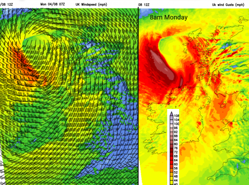
Currently, the main core of strongest winds is to the north of the more highly populated Central Belt with the highest gusts for the Western Isles. There could be slight movement on the timings and exact location of this core of violent winds and high gusts. Shown are the UKV charts from the 12z run on Sunday 3rd.
There are a variety of warnings from the UK Met Office and Met Éireann
Ireland - off the North Coast Marine warning Status Orange - “Storm warning from Bloody Foreland to Malin Head to Fair Head. Westerly winds may reach storm force 10 at times. Valid: 09:00 Monday 04/08/2025 to 12:00 Monday 04/08/2025” Met Eireann. Over land Status Yellow - Wind and Rain warnings for northern and western counties of Ireland, mentioning dangerous travelling conditions, falling trees and power outages.
Although this will be a significant windstorm, there will also be heavy rain and large waves where the gales blow onshore.
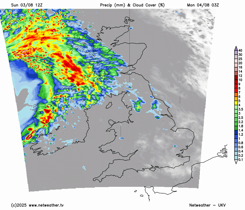
Heavy frontal rain will arrive early in the morning from the Atlantic spreading over northern and western areas. Skies will brighten behind the main fronts with sudden squally bursts moving southeastwards over Wales then England during Monday. Watch out for this band on the Netweather radar. There will be poor visibility and plenty of surface water and spray from this. Closer to the low centre, with the wrap round of the occlusion, will be the violent gusts, the storm force winds and hefty downpours.
The inshore waters forecast for the Western Isles “Wind… becoming cyclonic 6 to gale 8, then west or northwest gale 8 to storm 10 later, occasionally violent storm 11 later. Sea state - Moderate or rough, becoming rough or very rough later, then becoming high for a time”
The wild weather will last through the afternoon for the far north of mainland Scotland and the Moray Firth, impacting Orkney into the evening before dragging away eastwards into Monday night.
Do prepare now and be aware that conditions will deteriorate on Monday morning.
More chat in the Netweather forum Storm Floris
Loading recent activity...