After a period of quite stagnant, low-pressure-dominated weather, a change is underway as we head into the final weekend of July. The pattern is turning more mobile, allowing a classic north-south split to develop across the UK. While a cooler, breezier Atlantic flow will bring sunshine and showers to the north and west, it also clears the way for a ridge of high pressure from the Azores to build into the south. This will bring warmer and increasingly settled conditions there, but not before a risk of some heavy, and perhaps thundery, downpours along the boundary between these two air masses this weekend.
The synoptic chart reveals a classic British picture lining up for the weekend. The key interaction is between a ridge of high pressure trying to build from the Azores and a frontal system being driven southeastwards by low pressure in the Atlantic.
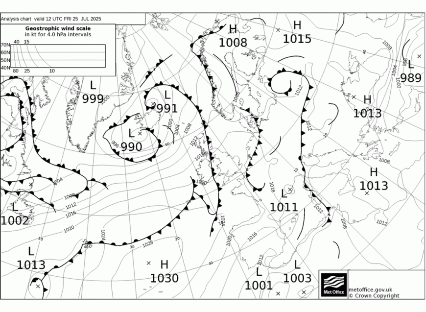
This front acts as the dividing line across the country, separating the cooler, showery Atlantic air to the northwest from a warmer, more humid airmass to the south and east. It is within this warmer air that home-grown, heavy showers are likely to be triggered into the weekend.
For Saturday, the front will continue its slow journey southeast. This will bring a cloudy start with outbreaks of rain and drizzle for parts of the Midlands, southwest England and Wales, but this will tend to break up during the day. Following behind, a mix of sunny spells and scattered showers is expected for much of the north and west. For Scotland and Northern Ireland, it will feel fresh in a brisk southwesterly breeze, with showers, some heavy, blowing in from the Atlantic. The West Highlands are likely to see the most frequent showers, merging into longer spells of rain at times.
Meanwhile, across southeastern England and East Anglia, Saturday will be the warmest day of the weekend. With sunny spells developing and temperatures climbing into the mid-20s Celsius (perhaps 25-26°C in London), the atmosphere will become quite unstable. This creates a homegrown risk of scattered but potent convective downpours developing through the afternoon. It’s a day to keep an eye on the sky; not everyone will see a shower, but where they occur, they could be quite sharp.
Moving into Sunday, the general theme of sunshine and scattered showers continues for most. The showers may become a little more widespread across England and Wales than on Saturday, but still relatively few and far between in most places. Temperatures will be a touch down on Saturday's values but still pleasant in any sunshine, remaining close to the late-July average. Most places will see temperatures in the high teens or low 20s Celsius. The north and west will again see the breeziest conditions and the highest frequency of showers.
Looking ahead to the start of next week, the Azores ridge is forecast to exert more influence. For many parts of England and Wales, Monday is shaping up to be a much-improved day, with drier conditions and more prolonged spells of sunshine as high pressure takes a firmer hold. This settled spell looks set to continue into Tuesday for the south. However, the northwest of the UK will remain more changeable, as further Atlantic systems are expected to bring breezy conditions and spells of rain, particularly to western Scotland.
Loading recent activity...