Showers may temporarily dampen the ground, but no widespread substantial and persistent rain is forecast on the horizon for many parts of England over the next 7 days at least - while heat may return too to southern, central and eastern England later this coming week, exacerbating demand and the dryness by increasing evapotranspiration. Most parts of England have seen below average rainfall since winter, with the lack of rain having increasing impacts on farming and also water levels in rivers and reservoirs.
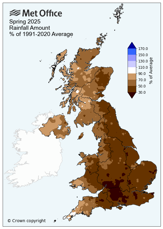
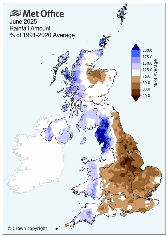
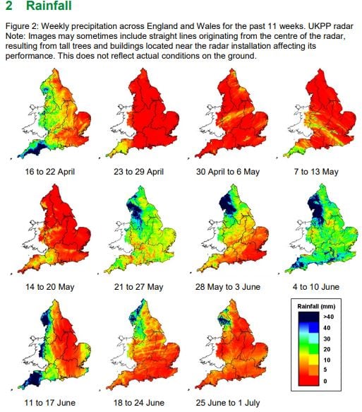
After England experienced its driest March, April and May since 1893, summer so far has also been rather dry too away from SW and NW England - with below normal rainfall - particularly across eastern areas of England.
Spring rainfall anomaly
June rainfall anomaly
On the 12th June, Yorkshire became the second region to enter drought status following the driest spring in 132 years, following declining river flows and groundwater levels through March, April and May. The first region of England to enter drought status was the north-west of England on 21st May. However, recent wet weather in this region has helped stabilise the situation and improve reservoir levels, but the area remains in drought. Some reservoirs have shrunk to half their volume and without substantial rain other regions of England could also enter drought status.
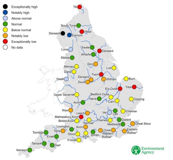
River flows at the end of June were about the same as - or even below - previous drought years of 1976, 2011, 2018 and 2022 for many eastern, central and southern regions.
The map below, published on 1st July, shows river levels across England, river levels notably low across parts of northeastern and eastern England.
Reservoir levels show a varied picture. At the end of June, the northwest regional reservoir capacity total was 65%, though in Cumbria levels are near full, following recent rain, while in the Pennines total was 47%. In the Severn Trent region covering the Midlands - levels at the end of June were 74%. In Yorkshire - reservoir levels are around 63%.
Groundwater levels in SE England, where much of water abstraction comes from in this region, are still around normal for now, as aquifers still have levels built up following the long wet spell that ended in 2024.
The lack of rain since winter and the subsequent increasingly dry conditions are having an impact on farming. Rainfall at the start of June had helped increase river flows briefly but these have quickly receded, and soils are becoming increasingly dry across most of England.
As a result, there has been a greater demand on farm irrigation reservoirs, especially where there have been restrictions on abstraction licences, impacting on surface water abstractions, due to low river flows. The early start of the irrigation season, due to the dry spring and increased demand on reservoirs have caused a depletion in storage capacities in early summer. Should the dry weather continue over the summer, this may cause issues for farms using irrigation where storage reservoirs are currently low.
Where farmers do not have access to irrigation, there has been reduced crop growth, particularly less well-established spring crops. Also, livestock farmers have been impacted by reduced grass growth, which may also impact winter feed supplies, with lack of grass growth to make hay.
Low pressure close to the east will bring a chance of showers, locally heavy, on Sunday and Monday across northern and eastern England, some spots in these areas may see some decent rain, others not much, being the nature of showers. High pressure builds back in from the Azores from Tuesday across England and Wales, keeping Atlantic frontal systems with cloud and rain confined to Scotland and N. Ireland. So much of England and Wales will be dry for the rest of the new week. Signs of heat returning later in the week too, especially across central, southern and eastern England - with temperatures reaching the high 20s centigrade, perhaps into the low 30s next weekend - which will increase demand of water and evapotranspiration.
Loading recent activity...