More heat and humidity for eastern Britain but prepare for torrential downpours and gusty winds as pulses of heavy rain and thunderstorms head north, starting on Friday evening
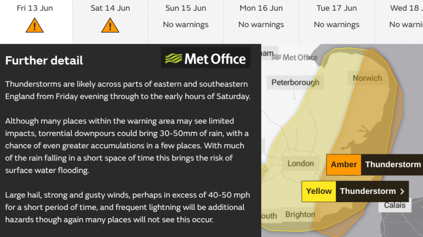
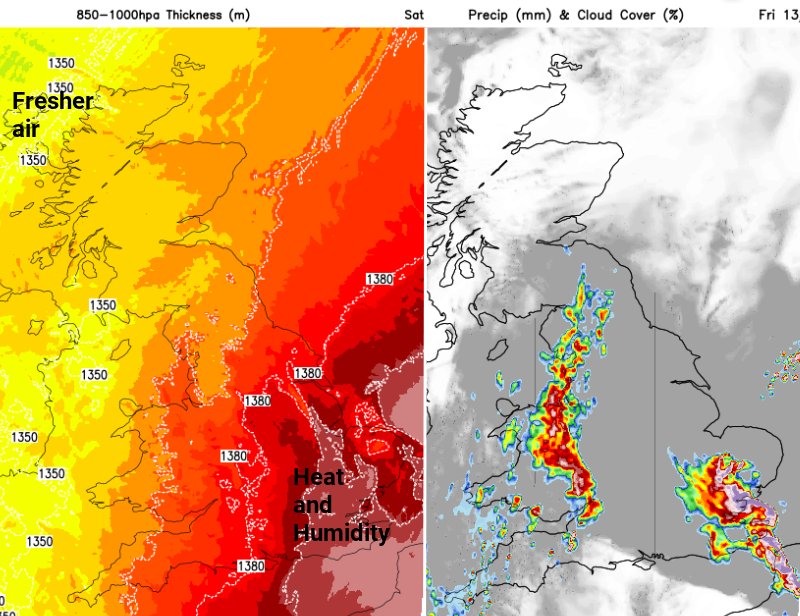
For the end of the week we have more very warm and humid air, the threat of thunderstorms with heavy downpours and a change by Sunday to a fresher, westerly flow. An Amber warning for Thunderstorms has now been issued by the Met Office for Friday night.
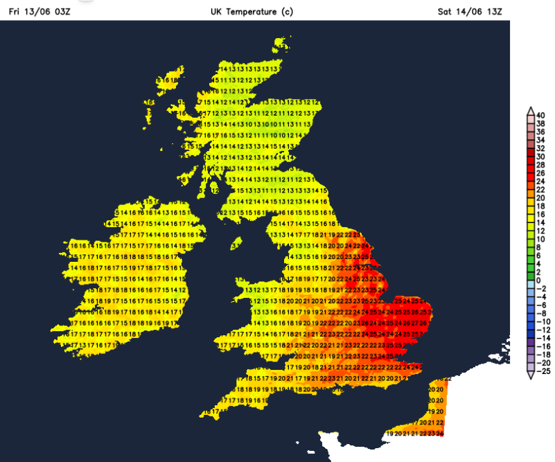
Friday temperatures will be rocketing where there are clear blue skies and sunshine. Before 9am, eastern England was at 21C and also the far north of Scotland. This was helped by the Fohn Effect in a brisk southerly flow, lifting and drying the air over the Cairngorms.
Northern Scotland could see 24 or 25C today and central and eastern England could see 27 to 29C. Manston in Kent saw the highest temperature on Thursday with 27.2C. The highest temperature so far this year remains 29.3C from the 1st of May at Kew Gardens so that might be beaten today.
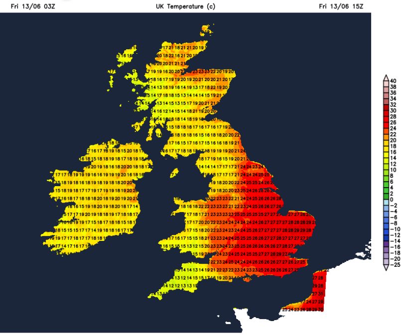
Some areas have more cloud for Friday and outbreaks of rain. Northern Ireland and western Scotland could see a few sharp showers this morning and there will be a scattering of heavy, even thundery showers for the northern half of Scotland from lunchtime onwards. Many places will miss these and remain fine and warm. Through the Central Belt up to 22C in a brisk southerly wind and for Northern Ireland, 19 to 22C. Wales will vary from 18 to 24C due to cloud cover and a different air mass. There will only be light winds and showers from the south later in the day.
The heat and humidity remain to the east of the frontal zone allowing the Midlands, London (possibly up to 30C), the Home Counties, Yorkshire and East Anglia to have a hot Friday with plenty of sunshine and very high pollen levels.
More in the Convective forecast about tonight's thunderstorm action.
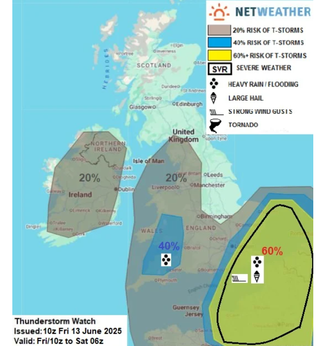
“with the high CAPE values, large hail (up to 2-3cm diameter) will be possible with strong storms, along with powerful downbursts with locally damaging wind gust risk (50-70mph) and very high rainfall intensities (50-60mm per hour) - especially where a MCS forms, as forecast by high res models across Sussex, Kent and eastern E Anglia. Frequent C-G lightning will also be a risk with this activity”
An amber warning has now been issued for Friday evening and the small hours of Saturday morning. This area is the focus for the possibility of severe thunderstorms and wild conditions overnight. There are two Met Office yellow thunderstorm warnings. One starting mid-afternoon on Friday for SE England into East Anglia.
“Thunderstorms may bring some disruption during Friday evening, and overnight into Saturday.” MO
And another for SW England, central southern England and much of Wales for this evening. This is then expanded in area, up through northern England into SE Scotland for Saturday.
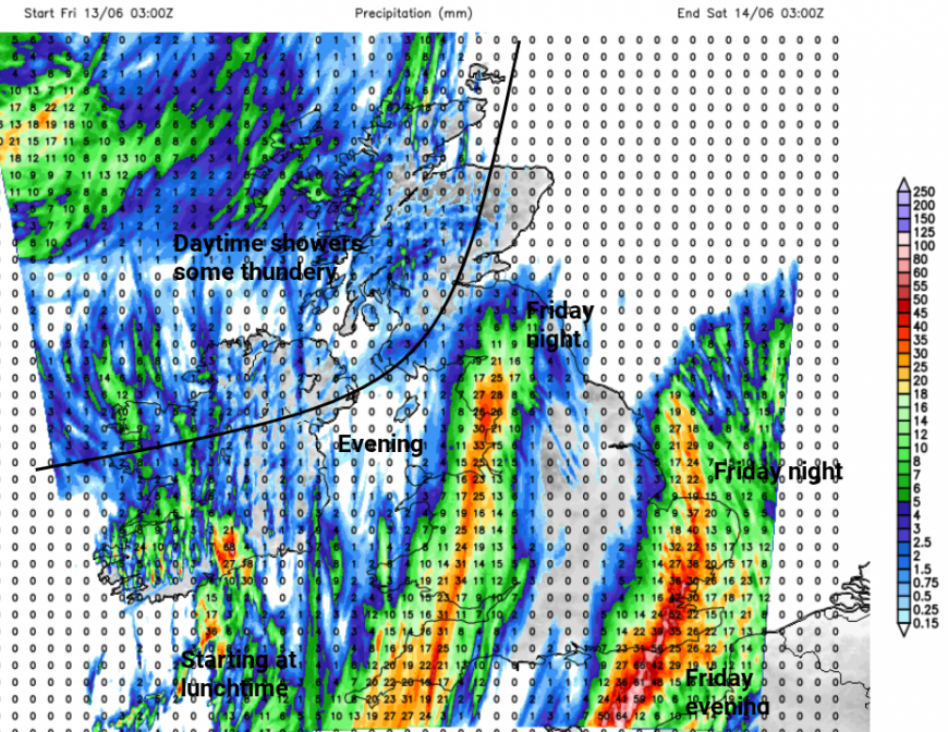
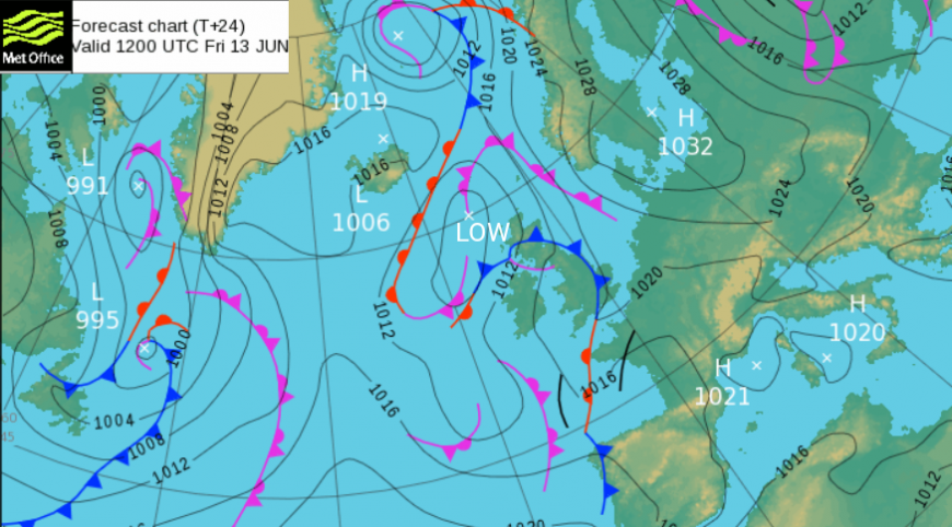
Through Friday evening and overnight into Saturday there will be pulses of heavy rain and thunderstorms making their way northwards. As low pressure moves over the UK there will be bands pivoting north with times of torrential downpours. Embedded in these will be thundery bursts with lightning and gusty winds. The heavy rain brings the risk of large puddles and flash flooding with difficult conditions on the roads. This is a nightmare for event organisers this weekend as there is the threat of thunderstorms but uncertainty about which particular areas will be affected. There are large gaps between the clusters, corridors of fine weather.
The rain will reach Cornwall and Devon by early afternoon and head up into Wales by early evening. The main threat for SE Britain doesn’t look to arrive until early evening but if any surface-based thunderstorms do break out ahead of the main zone, they could cause isolated disruption in all this heat and humid air.
It is the threat of severe thunderstorms for SE Britain which is causing the most concern, although they do move through overnight. This could produce some spectacular lightning shows once it does go dark.
Met. Office “Although many places within the warning area may not see any impacts, torrential downpours could bring 30-50mm of rain, with a risk of even greater accumulations should thunderstorms line up...large hail, gusty winds and frequent lightning to some places which could cause damage and power cuts.”
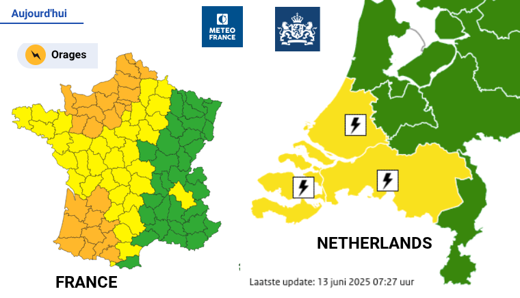
Meteo France has amber warnings for severe thunderstorms later today. “Significant thunderstorms will deteriorate late Friday afternoon and evening in the southwest and north, with a high risk of locally severe weather”. The Netherlands KNMI has also issued storm warnings.
The Arome model has intense thunderstorms moving through the Straits of Dover, clipping Kent and Suffolk, eastern Norfolk tonight. Also impacting NE France, Belgium and SW Netherlands. Other models bring the severe storms up through SE Britain. It will be a warm and muggy night for SE Britain and these storms could bring very strong, gusty winds and large hail. Do prepare for a possible change in the weather tonight. These will have cleared away before dawn.
The other warned area doesn’t have quite the energy of the southeastern region but could still see heavy rain, thunderstorms and the risk of strong gusts and hail.
However, this will continue intothe daytime and so will impact more people trying to enjoy their weekend. Rainfall totals could reach 50 to 80mm.
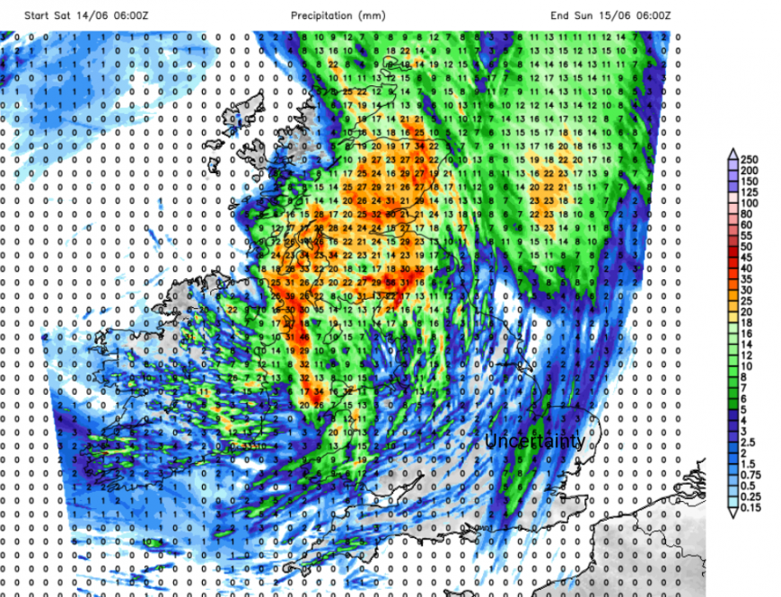
The Friday evening and overnight pulses of rain will move from Wales to NW England, into southern Scotland early on Saturday. The UKV Model is showing a pulse of heavy rain for western Wales and the Irish Sea early on Saturday with another cluster of showers moving over southern England towards The Wash. There is some uncertainty about this eastern area between the models, some keeping it dry.
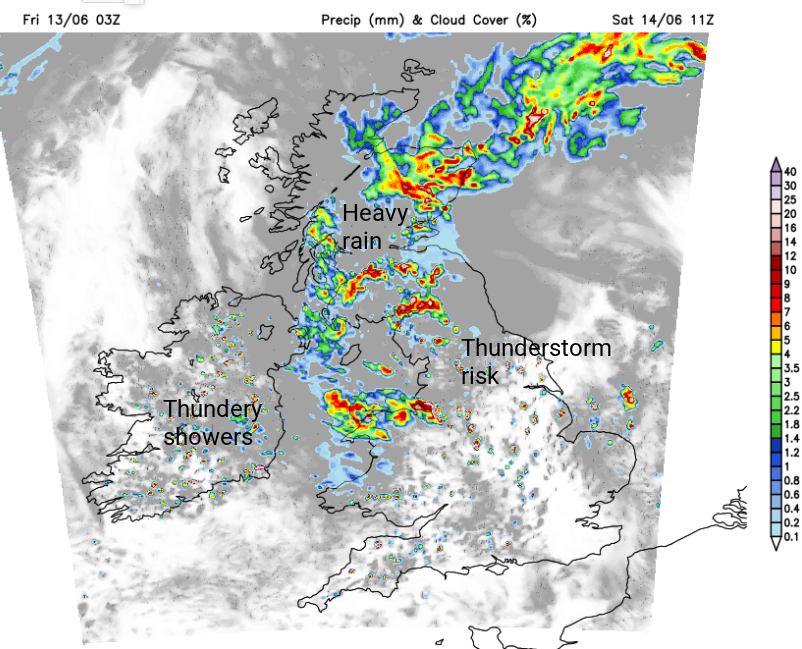
There will be a drift northwards, for the frontal rain, thundery downpours and showers. The risk of surface-based thunderstorms popping up remains in the middle of the day but focused on northern England with southeast England seeing more in the way of fine, dry and sunny weather. By Saturday evening it will be Scotland with the remaining showery outbreaks and downpours as much of the UK sees bright even sunny conditions. A moderate SW/W wind will pick up across England during the afternoon, swirling around the low pressure. It will remain very warm for eastern England on Saturday with 27 or 28C possible for Kent and East Anglia.
Sunday looks rather mixed but certainly less lively. There will be more cloud with outbreaks of rain in the west. More in the way of sunshine further east and it will feel warm in the June sunshine. However, the heat and humidity will have faded as we pick up a fresher, westerly flow off the Atlantic with temperatures around 17 to 23C.
Loading recent activity...