In summer, wide areas can be covered by yellow thunderstorm warnings from the UK Met Office. Does this have to spell disaster for event organisers or just need more understanding?
Yellow thunderstorm warning areas are tricky if you are organising an event and one appears for your region. A Met Office warning has three key areas to consider. Timings and text details, as well as the likelihood and the potential impacts.
Just because a warning for thunderstorms has been issued, it does not mean that everyone inside the area will see, experience or be impacted by a thunderstorm. It is all about heightened risk.
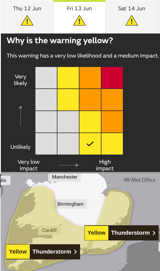
The ingredients are present in the atmosphere for thunderstorms to develop and the warning area has been highlighted because of the possible impacts if they do occur. This relates to Likelihood. Will severe weather occur; Unlikely (a very low likelihood), up to Very Likely which often is reached in the day before an event as certainty grows. An early warning would tend to start with a lower likelihood if issued several days in advance.
Yellow warnings into Friday night, with the SE England one lasting into Saturday morning.
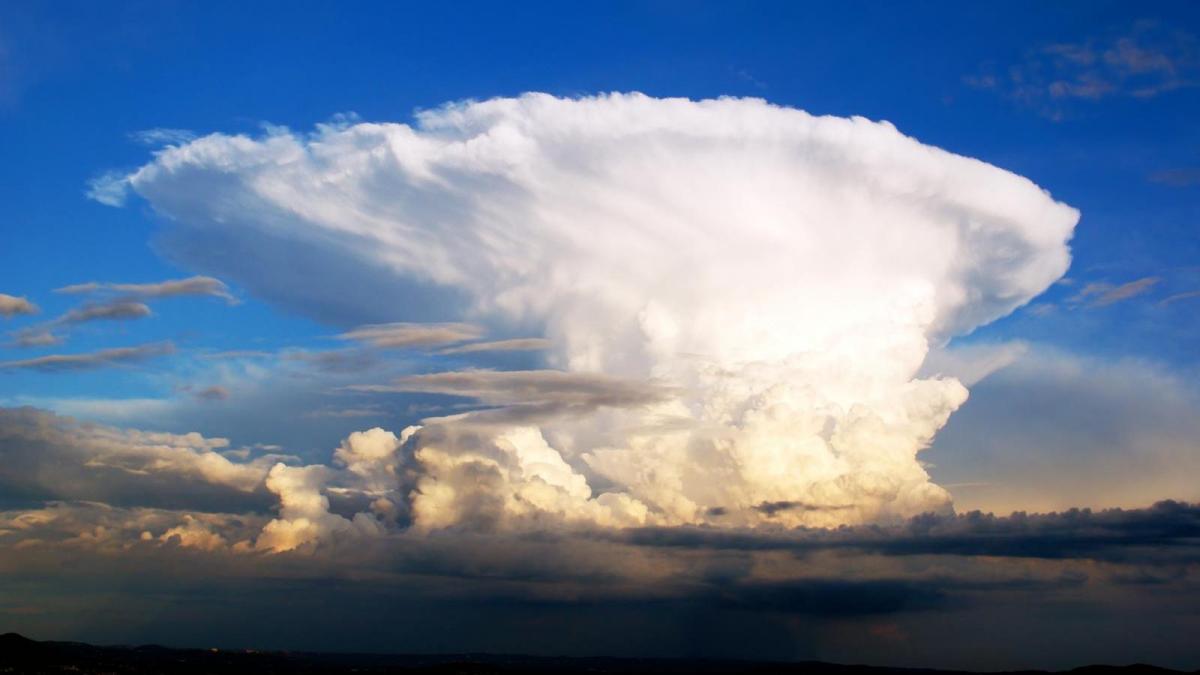
Thunderstorms are convective, like rain showers. They differ from large-scale frontal rain or windstorms. If a yellow wind or rain warning is in place you would expect to see heavy rain or experience strong winds across the warning area. The warnings are impact-based so sometimes places outside the warned area also experience heavy rains and strong winds. The Met Office has not deemed the forecast impacts not high enough to warrant a warning. This often causes a lot of debate online.
Likely impacts are the other main part of a warning; from Very low, Low, Medium up to High impacts. The problem with lightning is that one strike can be fatal. For mountain climbers and golfers, they want to know about any thunderstorms and the risk of lightning on that day.
The last important area is within the text in a thunderstorm warning; the forecaster’s headline text and Further Detail. Just looking at the colour and area of a warning might not help your decision-making. Following these steps through the Met Office warning and checking out the Netweather Convective forecast could give extra information to help organisers and decision-makers.
MAP Click on the date of interest and then your warning area. This area is then highlighted with a white outline and should show the timeline information at the top.
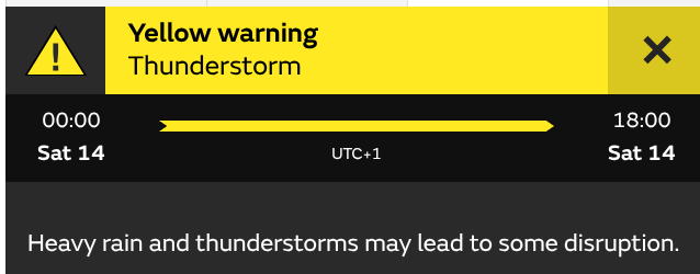
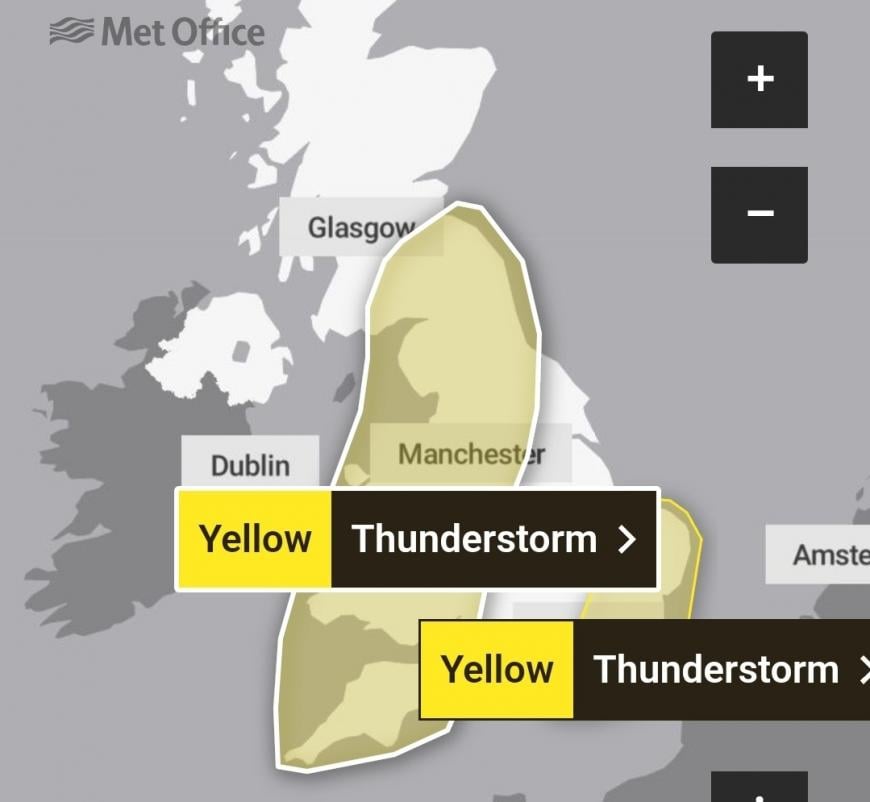
The main thunderstorm warning for Saturday 14th June 2025 runs from midnight early on Saturday right through until 1800, so 6pm. That is Friday night until Saturday evening. There is a large area marked from SW England, over Wales right up to SE Scotland. Sometimes two areas can relate to the same text but often they have different time frames. The weather will change a lot during these 18 hours.
TEXT The headline text says “ Heavy rain and thunderstorms may lead to some disruption”. The key word here is ‘may’. This is introducing the uncertainty about these showery downpours, that some areas will be hit whilst others may not be affected at all. This is what makes this kind of convective forecast frustrating at times for the end user.
Further detail - This paragraph of text is written by a forecaster and gives more detail. For Saturday 14th, it considers the movement of the heavy rain and thunderstorms. It builds the story behind the simple picture of a yellow warning area. Sometimes there are text updates lower down before the list of counties, titled “Last Updated”.
A weather app might just show a progression of thunderstorm symbols or heavy shower symbols. This highlights the risk of these showers rather than 'it will happen" in this hour.
THE MATRIX This is a very important part of the warning, it explains what type of yellow warning we are seeing. The likelihood of a type of severe weather is shown on the vertical axis and the level of impacts is along the horizontal axis. Combined, a colour is chosen.
For Thunderstorms (and other severe weather types) the levels of impact are Low, Medium and High
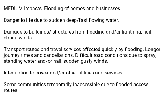
Medium impacts for Thunderstorms Met Office.
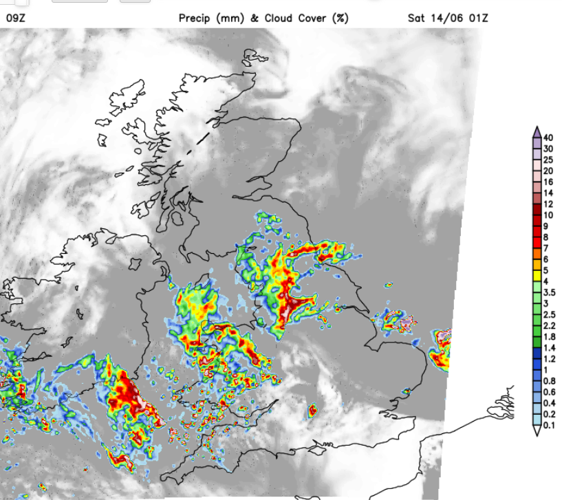
Looking at the UKV model for Friday night, 2am on Saturday shows pulses of heavy rain pushing northwards through Britain. Within these, there could be some torrential downpours and thundery bursts. The detail on where will be affected by those downpours will gain confidence as we head to the end of the week. Bands of heavy rain pivot over Northern Ireland and Scotland and as low pressure sits over the UK, there will be sunny, warm weather for much of England particularly eastern England in the mid to high 20sC.
.png?no-cache=1749743167342&w=870)
However, as the warning continues a scattering of heavy showers and isolated thunderstorms will begin to develop. Examples are circled in orange on the chart above, for Saturday afternoon. If you are under one of those there will be heavy rain, perhaps hail, gusty winds, lightning and a spell of horrible weather. Three miles down the road it’s just more sunshine and fine weather. That is the difficulty with a wide area yellow thunderstorm warning.
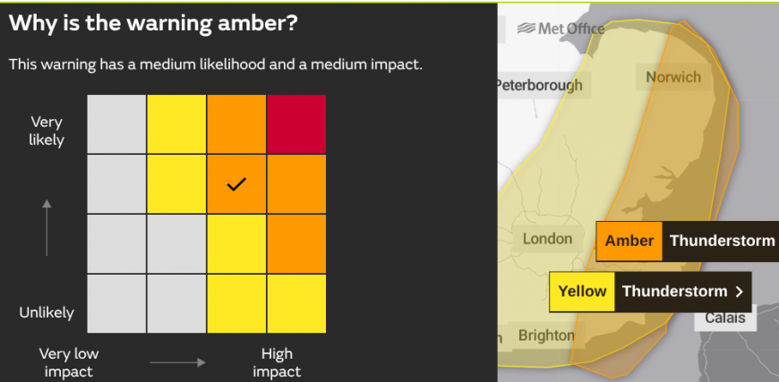
UPDATE- the Met Office has now issued an Amber Thunderstorm warning. You can see the change on the Matrix, still the risk of the same Medium impacts but now considered Likely to occur in the region marked. It could have moved to High Impact and Likely due to the severe nature of these storms but this is overnight so fewer people out and about.
In the United States, thunderstorms are often severe, even producing tornados. Their warning system is more detailed with more information at the front, not hidden away behind several phone app clicks.
What can you do?
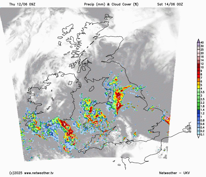
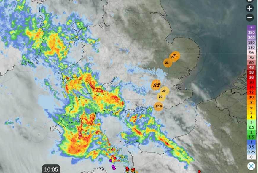
On the day, watch the Netweather Radar. Animate the radar feed to see how the showers are moving and add your location so that a marker appears on the map. In real time you can watch developments, see how the showers are moving and remember to turn lightning/sferics ON. Above is the Netweather Radar for Thursday 12th June as thundery rain reached the Channel Islands mid-morning and the heat built over eastern England with temperatures passing 20C.
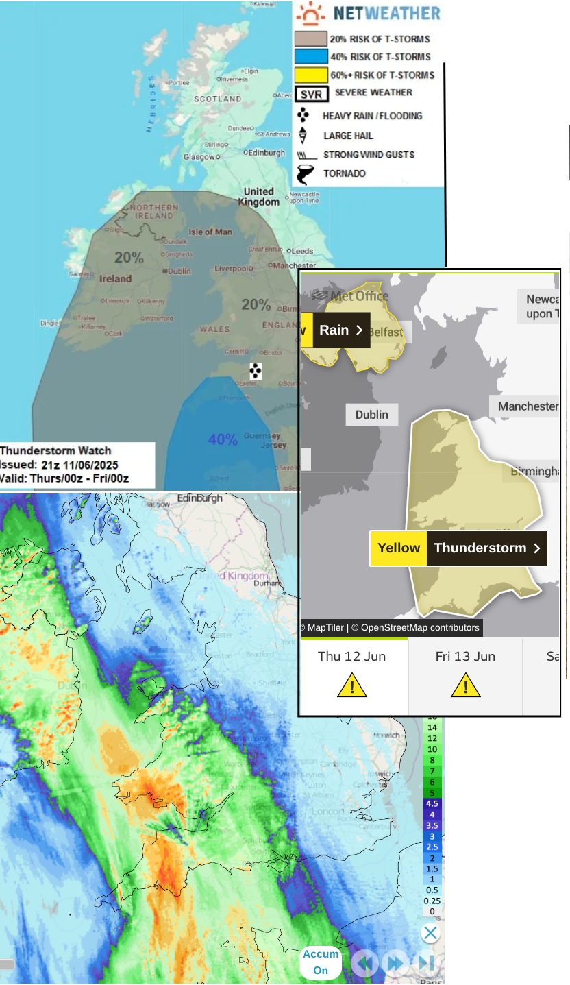
Looking back at the start of this thundery episode we have the Netweather Convective forecast for Thursday 12th, the Met Office yellow warning for Thunderstorms and the rainfall accumulations for 12 hours up to 16:50 on the 12th, showing where the heavy rain had fallen.
Sometimes extra detail appears on the Met Office warnings page, showing specific risk triangles for particular storms. This is an additional ‘nowcasting’ feature, The WMO defines nowcasting as “forecasting with local detail, by any method, over a period from the present to six hours ahead, including a detailed description of the present weather”.
There is always plenty of chat and discussion in the Netweather online forum and the Regional communities as the thunderstorm activity kicks off. Becoming familiar with the radar display, how showers usually behave in your local area and being able to glean all the information from the National Severe Weather Warning Service.
Loading recent activity...