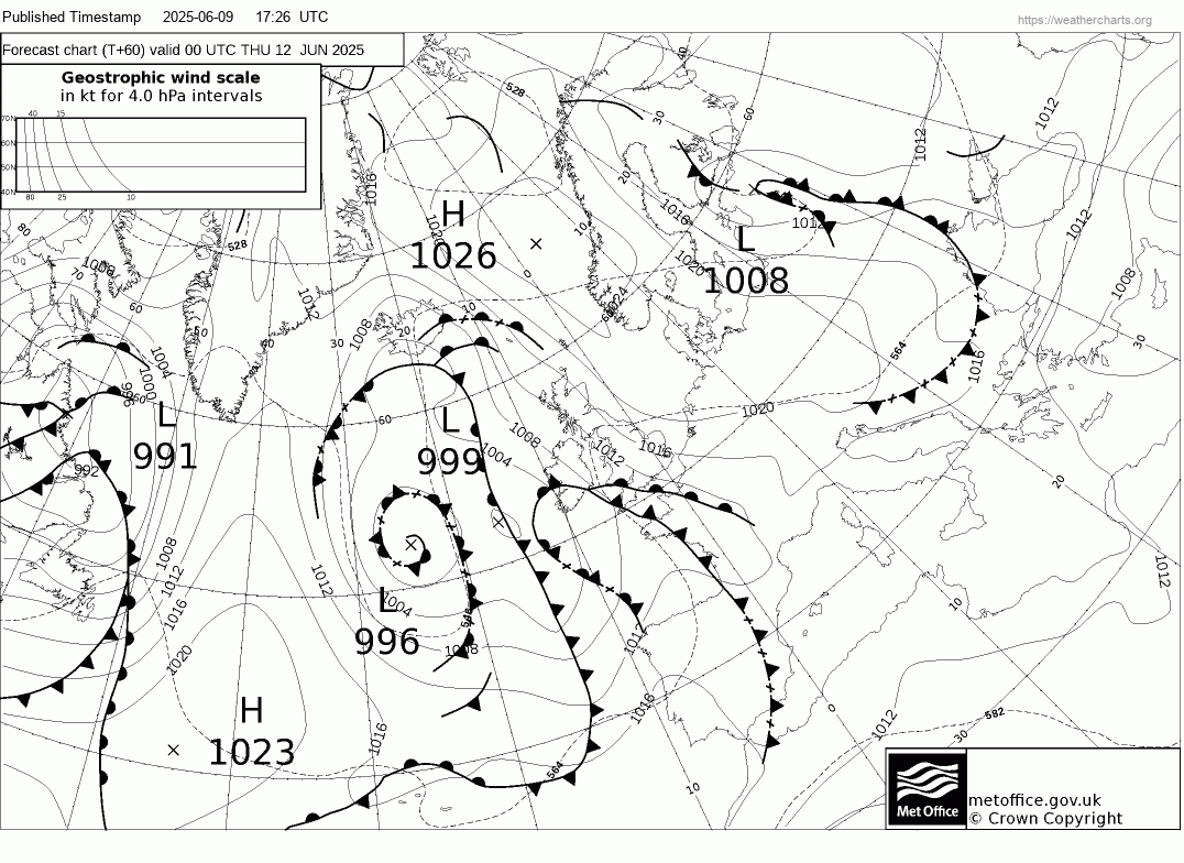
The weather remains changeable today and tomorrow, with the flow coming in off the Atlantic, with another low pressure system moving east across the north today, bringing a spell of rain to northern areas. Tuesday cloudy in the south with some patchy drizzle.
However, changes in the pressure patterns taking place over Europe and the North Atlantic by mid-week will bring much warmer and more humid conditions up from the south. Friday could be hot across southern and eastern England, with 30C possible, but there will also be a risk of thunderstorms on Thursday and Friday, before cooler and fresher conditions push in over the weekend.
Plume of warm and humid air will spread north from Spain from mid-week
The change to increasingly warm weather with a risk of thunderstorms will come about from changes in the jet stream. At the moment, a zonal (westerly) jet stream is running across the UK, bringing the changeable weather of late. However, later tomorrow, the jet will start to buckle and become more meridional to the west over the Atlantic, as an upper trough exiting NE Canada overnight moves southeast and amplifies south as it slows over the North Atlantic, merging with an upper low off Iberia. This slowing and amplifying of the upper trough to the west of Europe in tandem with a ridge of high pressure extending north over central Europe towards the North Sea and Denmark will back the flow from westerly to southerly from mid-week.
A plume of very warm and humid air, originating from Iberia - where temperatures reached 43C on Sunday in Adalucia, will spread north to southern Britain by Thursday. Temperatures on Wednesday look to reach 25-27C across central, southern and eastern England, low 20s elsewhere. There will be an increasing risk of thunderstorms developing from the southwest from later on Wednesday. There looks to be two waves of thunderstorms, one moving in across Devon and Cornwall Wednesday night, before a line of heavy rain and thunderstorms move northeast across other areas on Thursday morning before weakening as it reaches the northeast. Another wave of storms looks move northeast on Friday evening and overnight.
Shortwave trough and surface cold front moves northeast Thursday morning, bringing a line of heavy rain and storms
1st wave of heavy rain and thunderstorms spreading northeast Wednesday night / Thursday morning
Wednesday night and Thursday morning’s risk of thunderstorms appears to be tied to a shortwave trough moving northeast with a cold front developing at the surface, formerly the upper low off western Iberia, ahead of the main upper trough to the west. The shortwave trough and surface cold front will be accompanied by enhanced cyclonic vorticity, as shown on the animated chart below, which will create lift of plume of warm and humid air advecting north across southern Britain as the trough moves in from the southwest. A line of heavy rain and thunderstorms looks to develop along a cold front over the Bay of Biscay and western France before moving north-northeast across England and Wales on Wednesday night and Thursday morning. Forcing along the trough may relax from the south towards eastern England, where pressure will be higher, so risk of storms here lower than in the west. A band of rain reaching Scotland in the evening, but risk of storms perhaps fading, as the trough and forcing weakens by then.
Shortwave trough moving northeast and engaging plume of warm and humid air spread north will produce heavy rain and thunderstorms.
Friday is looking like the hottest day of the week and of the very warm spell, 15z UKV showing 30C in the London area and East Anglia, as the plume still in place is reinforced by a pulse of warmer air from the south towards SE England for a time. Temperatures widely reaching the mid to high twenties celsius elsewhere across England and Wales. However, another shortwave and surface cold front looks to move northeast later on Friday, with greater height and surface pressure falls and temperature gradient along the cold front likely to produce more widespread thunderstorms pushing northeast, more backed flow towards SE England and East Anglia could enhance vertical shear, bringing a risk of severe thunderstorms in the evening and overnight, but less certainty over this.
Possibly reaching 30C on Friday in the south

A second round of thunderstorms looks to move northeast Friday evening
Large amounts of CAPE (Convective Available Potential Energy) on Friday evening

Cold front moving northeast Friday night, with storms along and ahead of it, looks to be followed by slightly cooler and fresher conditions on Saturday, the brisk southwesterly breeze bringing showers to western areas, perhaps heavy towards the northwest nearer low pressure moving in. Drier and brighter towards the east, could still temperatures reach the mid-20s celsius across eastern England.
Loading recent activity...


.jpg?w=1200)