We’ve seen a shift in our weather for the last week of May with an unsettled Bank Holiday weekend and mixed conditions for those on half-term holidays. Will this coming weekend fare any better as May ends and we move into the summer month of June?
A succession of low pressures will continue to run across the UK in the next few days. England, Wales and southern counties of Northern Ireland saw a wet Tuesday from one passing low as showers bombarded the far northwest of Scotland linked to a different low pressure away to the north. Both of these are moving away as a large shield of cloud looms out in the Atlantic.
There will be a brighter lull on Wednesday with just a scattering of showers midweek. Tonight the frontal rain will arrive from the Atlantic, over Ireland ready for a very wet start on Thursday for Cumbria and western Scotland. Different fortunes compared to Tuesday as it is northern Britain seeing the rain by day. England and Wales will feel warmer as temperatures reach into the low twenties Celsius. Everywhere will become more windy as the rain turns to showers in the north. There will be bands of showery rain over northern Britain which last through the night into Friday morning. This will include early heavy downpours but clear eastwards. The trailing weather front over Wales will bring damp weather to western England for a time and extend more cloud into the Midlands. Otherwise, the cloud should break up and Friday will improve with sunny spells. Potentially even warmer for SE Britain, maybe up to 25 or 26C.
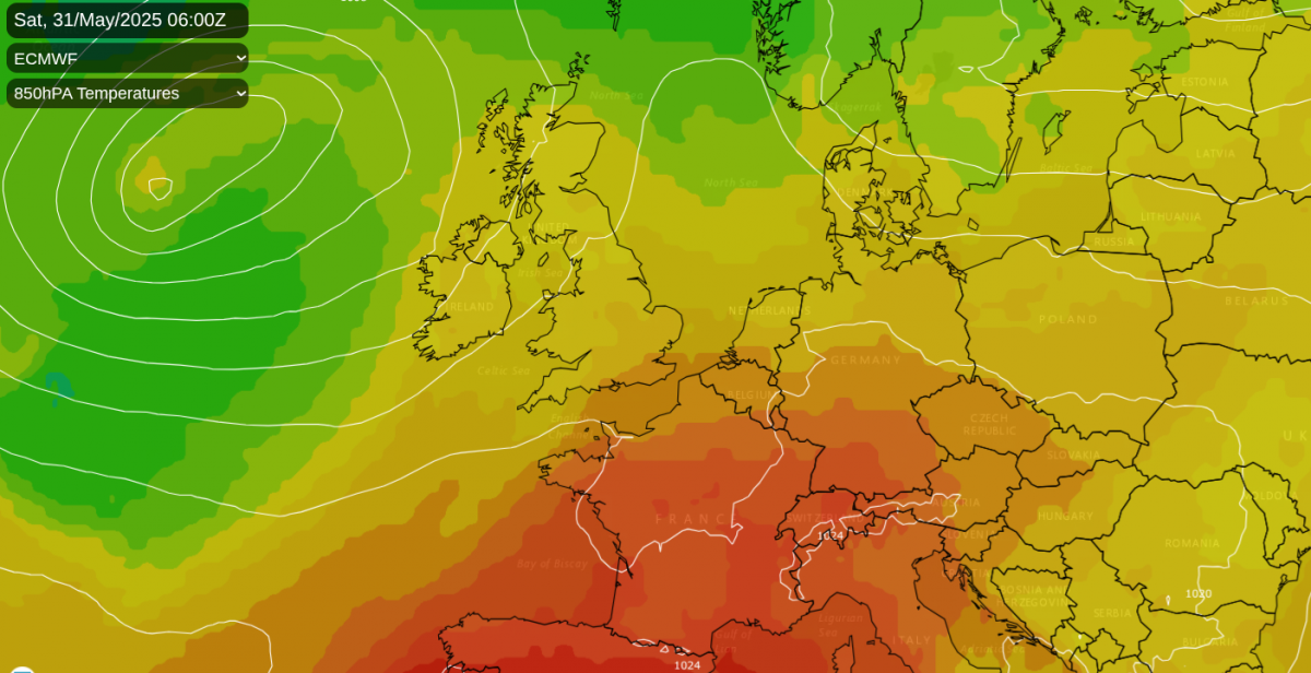
That warmth will last for the southeastern half of the UK into Saturday. Another low pressure will be heading our way from the northern Atlantic, bringing more cloud and rain but ahead of it the warm, more humid air will hold on. As that low whips through, it leaves the UK in fresher air for Sunday morning with plenty of heavy showers (mainly in the north). There will be bright spells in between with SE Britain more likely to escape the showers and see more in the way of sunshine, just not the heat of the previous two days.
It will be reassuringly warm in London on Friday evening. A feeling of summer, without oppressive heat but not that the daytime warmth that relies on direct sunshine and then you wish you'd brought a jacket as the sun sets. The air is warm and it will be a lovely evening in southeast England. Northern Ireland could see a few sharp showers. Wales and southwestern England are likely to have more cloud and some damp, murky conditions along the coasts for the end of the working week. This damp, grey weather for SW Britain could extend into the Midlands but there is some uncertainty here. If the frontal cloud does break up it will stay warm and fine for central England.
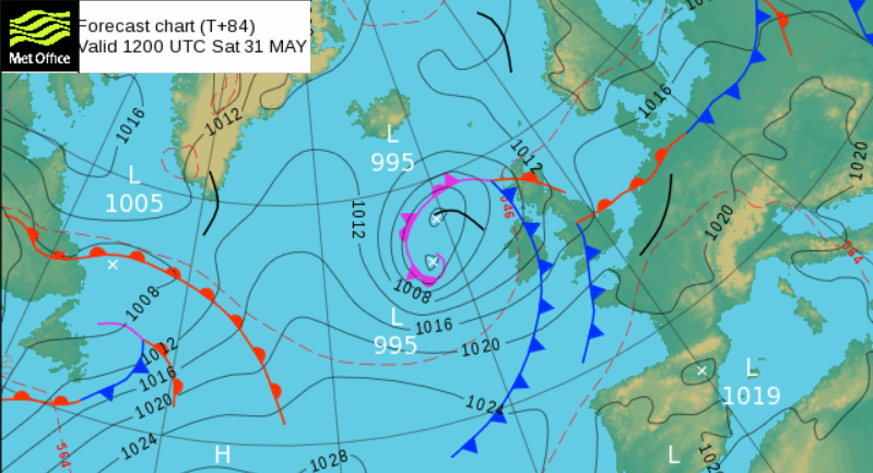
The pressure chart might look a bit ominous with another low pressure looming over the UK. The lingering front over England and Wales will keep cloud over the southern half of Britain to start the weekend with damp weather for Wales and southwest England but it will soon improve. For much of Britain, it will be bright, even sunny and feel warm. As the cold front arrives there will be a band of heavy rain for Northern Ireland and western Scotland with strengthening southerly winds through the Irish Sea by lunchtime.
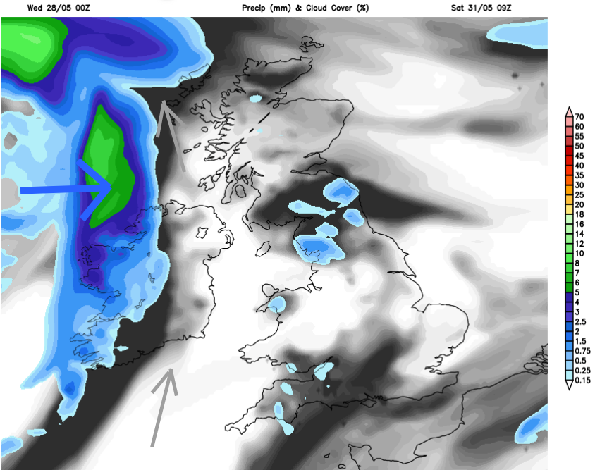
This distinct band will move eastwards over Scotland during Saturday with the risk of thundery bursts and gusty winds. Conditions over the hills and mountains will deteriorate so don't be taken in by a fine start to the day. Even as this band of rain clears there will be scattered heavy showers with the brighter skies, post-front.
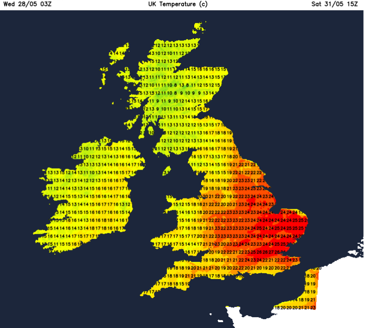
Eastern Scotland and northeast England will feel warm in the middle of the day whilst the weather is fine, up to 17 or 18C. Temperatures will be low as the frontal cloud and rain move in. In the warm air further south a good part of England and eastern Wales will reach into the 20s Celsius with 24 to 26C possible again in the sunshine for eastern England.
The trailing cold front will bring showery rain across the far north of England and Wales during Saturday evening. Fresher conditions begin to take hold from the northwest and feeling cooler by night to the end of the weekend. The Northern Isles will be wet for a time on Saturday night as clusters of heavy showers reach the west coast of Scotland, all swirling around the low centre.
There will be a brisk westerly wind on Sunday adding to the cooler feel to the day. Any summer sunshine will still feel warm in sheltered spots. It will be a day of sunny spells and scattered showers. More showers in the north with a few hefty downpours. With drier weather for southern England, London and the Home Counties could see temperatures up to 20 or 21C but the air will feel different. It will be Friday and Saturday which feel like summer whereas Sunday 1st June will feel like a fine spring day.
Loading recent activity...