This week there will be a lot of settled, fair weather as high pressure tries to hold on but cold fronts keep tipping over the UK from the northwest. The daytime temperatures will vary depending on cloud cover and so, sunshine amounts, and the strength of the wind. Temperatures are declining over the next few days and Friday looks colder for everyone with even a bit of snow over the mountains of northern Britain by the weekend. The far northwest of the UK will see a good deal of rain this week, particularly on Thursday when it extends to more western areas. However, for much of the UK, there will be a lot of fair, often dry weather this week with brighter spells coming and going.
Pembrokeshire saw nearly 19C on Saturday with other parts of Wales, and England, reaching 16 to 18C. The Isles of Scilly saw an inch of rain, 25.6mm, as heavy, thundery showers developed through the weekend. On Sunday, Swanage in Dorset saw the top temperature, 16.6C but Scotland and eastern England had a cooler day with temperatures often in single figures.
This week
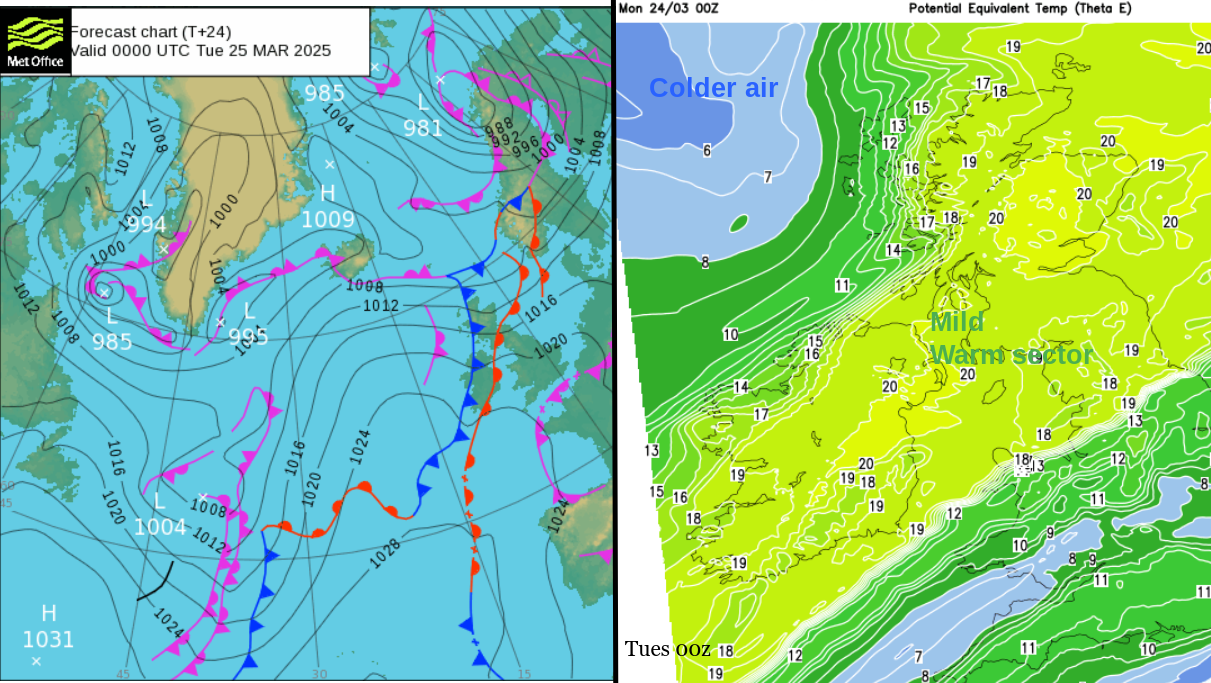
Frontal bands topple in from the northwest tonight with a brief warm sector keeping the overnight temperatures up for northern Britain and Northern Ireland. Southern Britain could dip down to 3 or 4C depending on the cloud breaks.
Tuesday
The fragmented frontal band will be stretching across a central swathe of Britain, from Wales to the Humber with thicker cloud and patchy outbreaks of rain. For southern England, there will be a fair start with sunny spells but the frontal cloud will increase from the north during the morning. It will take its time to reach Sussex and the south coast of Kent so a fine start to the working week here and temperatures should rise into the mid-teens. There will be a few showery outbreaks from these fading fronts over England.
Behind the frontal cloud, much of northern Britain and Northern Ireland will have a fine day. However, it will feel chilly in a brisk west wind for the far north of Scotland in colder air.
Tuesday night will be colder with temperatures well down into single figures and the chance of fog and patchy frost. There will still be banks of cloud that save some parts of Egnland from seeing temperatures fall as much with very light winds.

Wednesday
The next frontal bands will be approaching NW Scotland on Wednesday so the day will be blustery here with a SW wind and high cloud pouring in ahead. It looks like a dry, fine day with very light winds for Wales and England and more sunshine. The breeze will pick up slightly for Northern Ireland and Scotland but it will be a fair day with increasing cloud. Temperatures will range between 12 and 17C perhaps the odd sunnier spot up to 18 or 19C.
The frontal rain will reach NW Scotland and the north coast of Northern Ireland by Wednesday evening with fresh SW winds.
Wednesday night
Again there will be zones of cloudy milder air and clearer, colder parts. Depending on the progress of the front southwards there could be a touch of frost for southern England before the high cloud increases.
Thursday
The models diverge slightly with their progress of the frontal band southwards. So northwest England and western Wales could start the day damp and grey. Southeastern England and London should still be dry and bright but colder air will be following the frontal band in the far north. Here it will feel colder in the wind and the showery rain will flow off the Atlantic and just keep coming all day.
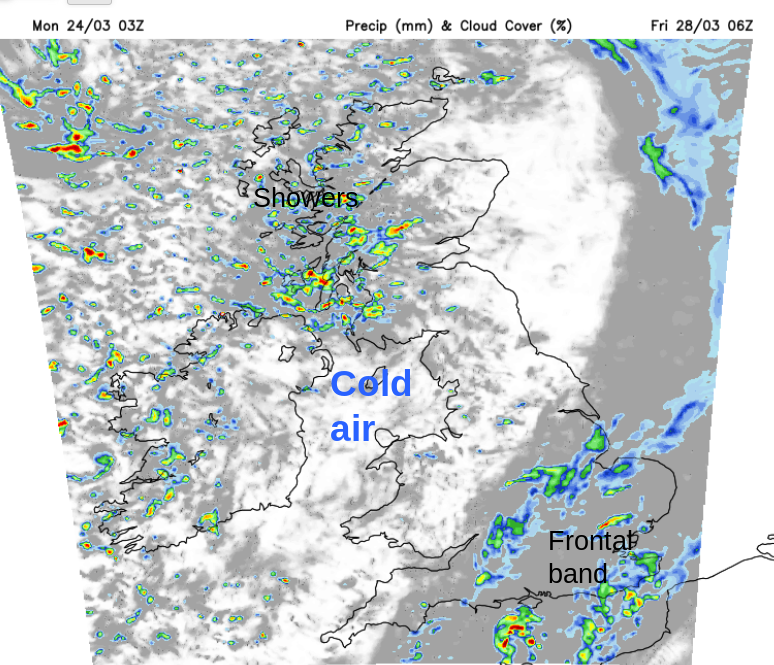
By Thursday evening another cold front will sweep the precipitation over Ireland and Britain allowing clearer skies, colder air and a rash of showers from the northwest.
Friday
London and the Home Counties could start Friday with showery outbreaks of rain but they will soon clear away towards mainland Europe. It will be sunny for most but the air will feel cold, so in the shadows and certainly after dark it will feel chilly. The fresh westerly wind will add to that chill and showers will run across the UK, with heavier clusters for Scotland. Here they could include hail and sleet, possibly lightning, with snow for the mountains. Exposed coasts and northern hills could experience strong to gale force winds veering from the SW to NW through the day. The cold air will last into Saturday.
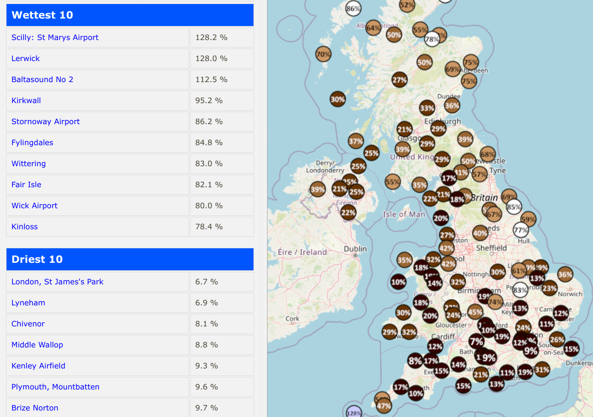
This will be another mostly dry week, in a rather dry month. Data displayed by Starlings Roost Weather shows how many locations have seen little of the expected rainfall for more than three weeks in March. High pressure looks to stay nearby even into April blocking the usual Atlantic low pressures.
Loading recent activity...