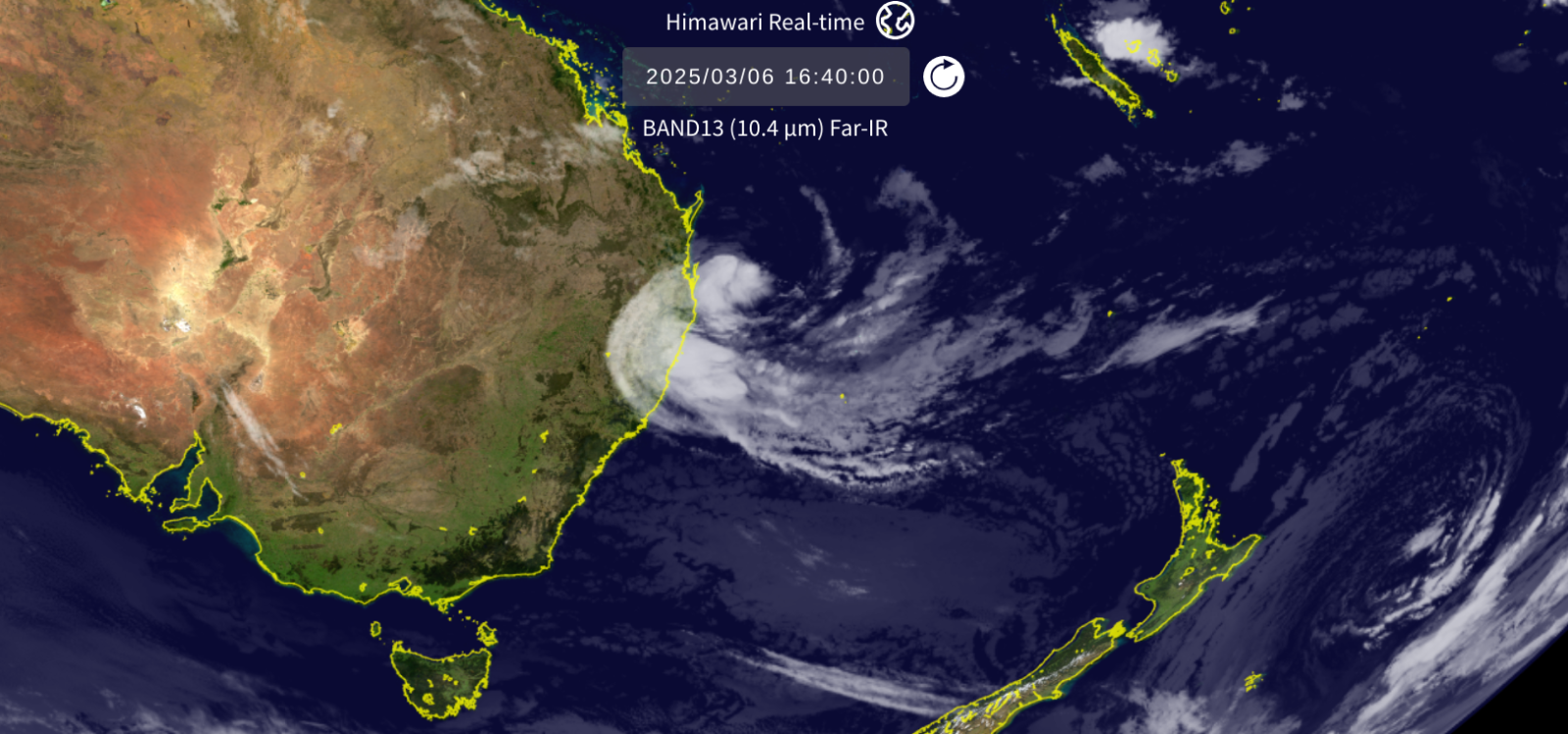
Brisbane, southeast Queensland and northeast New South Wales (NSW) are awaiting Tropical Cyclone Alfred. There have been warnings all week, allowing people to prepare with a slight delay to landfall as Alfred makes its slow, ominous approach towards the east coast of Australia.
“The tropical cyclone could cross the coast between Sunshine Coast and Gold Coast (QLD) on Friday night / Saturday morning. Conditions will get worse as it gets closer to land.” BoM
What to expect:
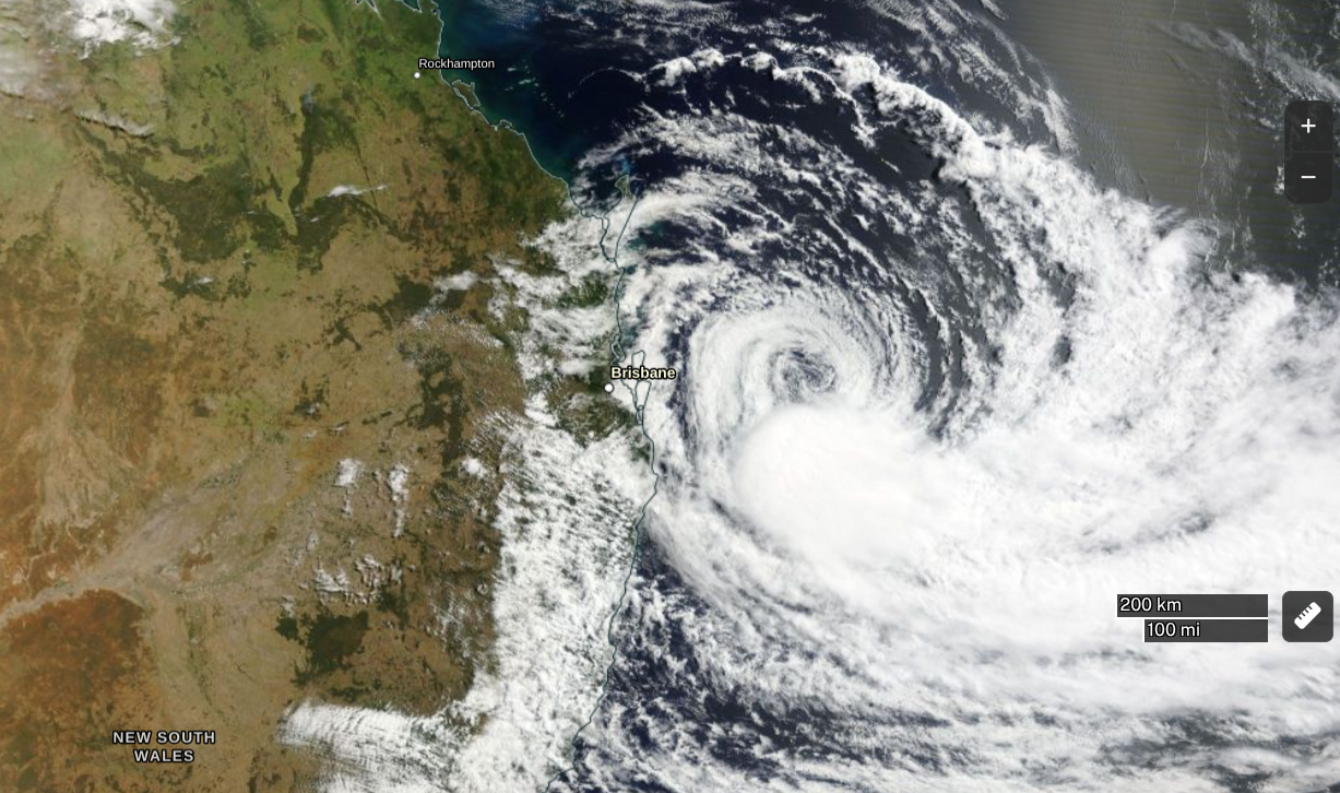
Queensland Premier, David Crisafulli, highlighted four key challenges; waves, wind, rainfall and flooding in the coming days. Already the wind has been ramping up as the initially attractive surf has turned to a wild maelstrom. There have been bouts of heavier rain, wetting the ground before the cyclone arrives but there will be flooding from the torrential rain around the cyclone, with a storm surge and coastal erosion. All of this alongside the damaging, even destructive, winds of a category two cyclone. This is the equivalent of a Tropical Storm in the Atlantic or eastern Pacific, not quite reaching hurricane status (a Cat3 cyclone) but Brisbane does not experience tropical cyclones very often. This is an unusual event, for a cyclone to make landfall near Brisbane. However, the city does experience devastating flooding. This last occurred just back in 2022, due to torrential rainfall and people still remember cyclone-induced flooding from 1974
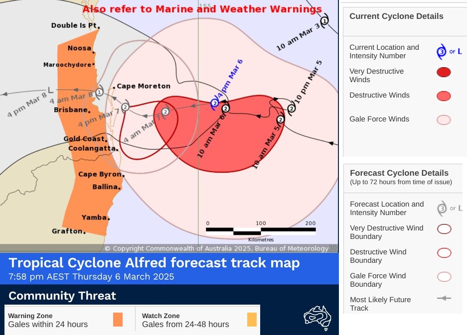
Alfred has slowed down and its path to landfall has wavered over recent days. A slow-moving cyclone can cause more coastal damage as the surf, swell, and huge waves pound the beaches and any defences. The heavy rainfall doesn't move on quickly. It falls in the same regions, onto increasingly wet ground which becomes saturated at the same time as the storm surge arrives. If high tide occurs at the peak of all of this, the flooding event is made even worse. Back in 1974, the flooding occurred with a King Tide ( like super Spring Tide). The cyclone could stall, could grind to a standstill, and the rain will dump on the same catchment areas. What is a huge concern for Brisbane is a landfall to the north of the metropolitan area, with the heaviest rain being to the south and inundating the city. Even as it moved westwards inland, the water would still flow towards Brisbane from the catchment areas onto the sea.
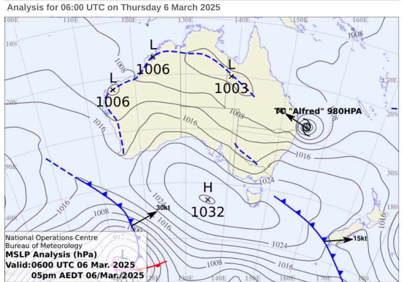
There is a high pressure to the south of Australia which is helping to direct Alfred westwards towards this heavily populated area, but only slowly.
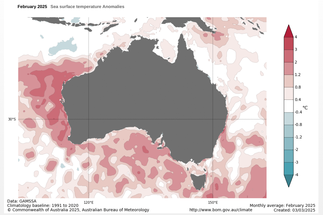
The seas in this area have been anomalously warm this year. The northeastern Coral Sea experienced its highest temperatures on record for January. Commonwealth Scientific and Industrial Research Organisation (CSIRO)
BoM is the Australian Bureau of Meteorology. BoM is tracking the cyclone, issuing the forecast path information, bulletins and warnings. Although the initial impacts are being felt, landfall is expected to be late on Friday or very early on Saturday 8th (local time at night). Areas highlighted include the Gold Coast and the Sunshine Coast with two states impacted. Already, there has been between 100 to 200mm of rain recorded with 200mm+ in some areas along with strong winds and gales for exposed coasts. Offshore there have been waves of 12-15m. Through the weekend, as tropical low Alfred moves inland with more rainfall, there will be strong winds and dangerous surf along the coast of northeastern NSW with more wet weather reaching Sydney, especially on Sunday.
Although this is not a powerful cyclone compared to the Major hurricanes in the Atlantic, this long-period event will cause severe damage and erosion along the coast and the flooding has the potential to be devastating. 400-800mm of rain is forecast with the possibility of higher totals and flash flooding for the elevated regions inland.
“ Leaving early is safer than waiting. Campers and caravanners should start packing up now.”
Coastal evacuations are already beginning. Bottled water supplies are being restricted. Communities are making sand bags and boarding up businesses and homes. Refuge centres are being advertised along with advice lines and people are being warned that there will be large fines for anyone behaving in a reckless way in the storm. Power outages are already occurring as flight cancellations begin. People in Brisbane have moved their cars as many shopping centres opened their multi storey carparks.
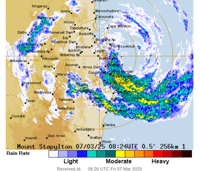
BoM Brisbane Radar Friday 18:25 (08:25UTC)
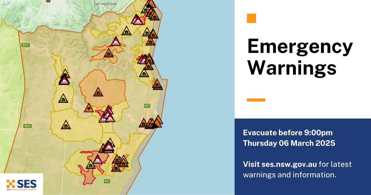
Thursday 6th The Sunshine Coast - PREPARE NOW for Tropical Cyclone Alfred that is moving slowly towards the Queensland coast.
City of Gold Coast advises people on the Gold Coast to PREPARE TO TAKE SHELTER tonight. Expect destructive winds and significant flooding. If you are in a risk area, decide now where you will take shelter. A storm surge will occur tonight. It may exceed the highest tide of the year by over a metre.
Trusted, timely information and clear, practical warnings are key in these situations. The World Meteorological Organisation (WMO) has stated that the need for early warning systems is more crucial than ever in our changing climate. Global co-operation for the Early Warnings for All initiative relies on "worldwide sharing of data collected from the Earth's surface and space. This information is freely exchanged between countries and analyzed by highly advanced supercomputing modelling centres."
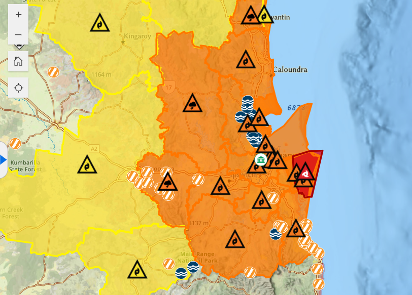
Emergency dashboard for Brisbane City Council showing; hazards on road/flooding/cyclone/rain warnings. Including red warning "TAKE SHELTER NOW - Redland City Island Communities - Issued at 9:00pm (Local time), Thursday 6 March 2025"
Although there is little that eastern Australians can do about the incoming cyclone, their warning system and communications allow preparation time, which does save lives. “Severe Weather Warnings are essential for Queenslanders to stay aware of changing conditions. Given the state's vulnerability to heavy rainfall, floods, and cyclones, it's crucial to know when extreme weather may affect you.”
This is not the case in other parts of the world. The UN Secretary-General, António Guterres said on World Meteorological Day, 23rd March 2022 - "one third of the world’s people, mainly in least developed countries and small island developing states, are still not covered by early warning systems... This is unacceptable, particularly with climate impacts sure to get even worse. Early warnings and action save lives. To that end, today I announce the United Nations will spearhead new action to ensure every person on Earth is protected by early warning systems within five years (2027). This action relies on ongoing global co-operation.
Further discussion in the Netweather forum - Australia weather
Loading recent activity...