Brisbane and south-eastern Queensland has seen devastating rainfall which led to an extreme flooding event. The deluge, over several days at the end of February, extended into northeast New South Wales and thunderstorms continued to bring the risk of flooding for eastern Australia into March 2022.

At least 9 people have died in this event, as 20,000 homes were inundated with floodwaters and even more lost power. There has been widespread damage and disruption. The media have been comparing to various historic levels and events.
“Northern NSW – record flooding above the March 1974 and major flooding above February 1954 levels is occurring.”
“Southern QLD- Major flooding occurring with a flood peak Monday evening reaching up to the level observed during TC Oswald in 2013.”
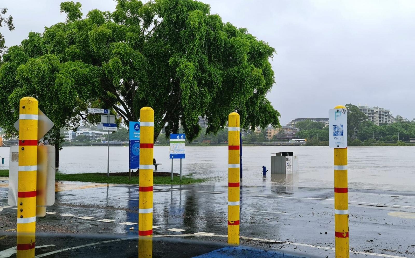
Mt. Glorious to the NW of Brisbane, in a tropical rainforest mountain range saw 1.42 metres of rain, 56” in about 5 days with 461mm falling 24 hours. There was so much water and it just kept on raining. Schools were closed, people evacuated, no trains and roads closed. Power cuts continue and there are supply issues for some foods. The rainfall was like amounts from a tropical cyclone and as it continued the rivers swelled and high populated Brisbane saw its river overtop, spreading far and wide. Even now the worst flooding has passed a smelly, toxic sludge remains with debris scattered about.
The River Brisbane meanders through the city of the same name. It is tidal and reaches the sea away to the northeast. Queensland has seen several major flood events, recently in 2011 when Brisbane also saw massive rains and major flooding. People also remember 1974 when NSW set its all-time monthly rainfall record with 1.62m.
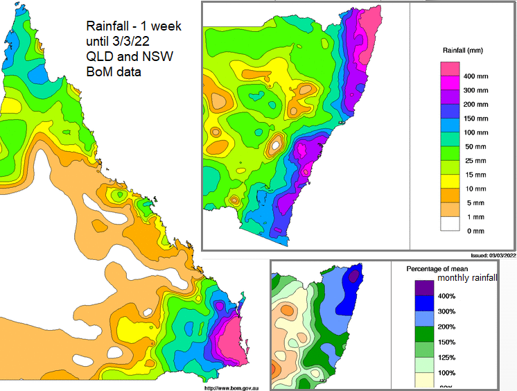
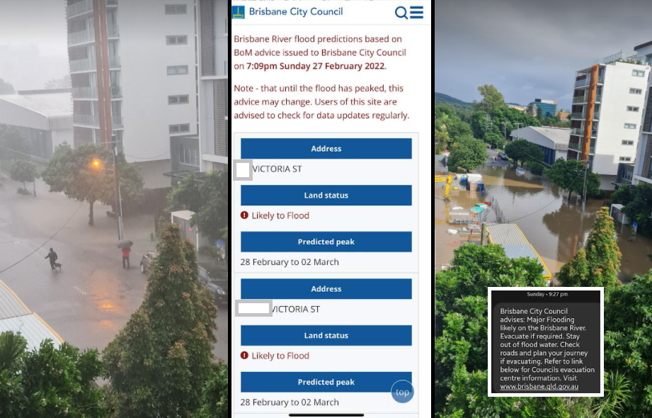
The River Brisbane reached Major River flood status as did the Logan and Albert River basins. The levels of warning are Minor, Moderate and Major. Dunoon, NSW received 775mm of rain in 24hours at the weekend which is the 2nd highest daily rainfall on record for NSW. Widespread heavy, even intense and thundery rain flowed into the rivers from the north and west of Brisbane. Bundaberg to the north saw 292mm of rain in 2 hours which lead to life-threatening flash flooding.
Also added into the situation is the Wivenhoe Dam which is a huge water storage for SE QLD and the main supply of water for Brisbane. As Australia lurches from weather extremes, drought to flooding, this dam provides reliable, safe drinking water. It can be temporary water storage in times of heavy rain allowing controlled water releases as flood mitigation. It can reduce the flow rate in the Brisbane River and the peak flood height. This happened in 2011 but the river system below the dams, so Brisbane city, is not controlled. Also, the flood storage waters have to be released. So, after the event but before any more heavy rains occur. The storage levels can’t get too high though. Releases can keep river levels high for longer downstream.
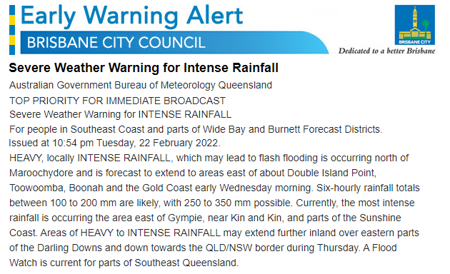
The heavy rain had been highlighted by BoM, the Australian Bureau of Meteorology a few days in advance. This was going to cause problems and people should begin to prepare. Early on the forecast had suggested that the area of heavy rain might weaken and shift at the weekend. However, it stalled and so continued with huge amounts of rain and so the terrible flooding. Warnings and broadcasts aided the population to deal with the situation, as it just kept on raining.
This area is on a flood plain with mountains to the west and northwest. Australia has had its wettest November on record, also the wettest for inland NSW and southern QLD. There was high soil moisture and after various rain events, water storage was high. 2021 was one of the wettest years on record for Australia. A coastal trough, an area of lower pressure parked itself off the east coast. It drew moist air down from the warm Coral Sea and then westwards onto the coast. Over the land and particularly as this warm moist air hit the hills, the rain fell. Inland there was an upper low, a pool of cooler air which brought instability to the situation. There was the large-scale setup and feed of rain but also localised thunderstorms adding an extra viciousness to the weather. It was labelled as a “Rain Bomb!” this onshore flow, hardly moving and seemingly endless rain. With antecedent wet year the land and rivers couldn’t cope.
2021 – “The extremely wet conditions were associated with a developing La Niña in the Pacific Ocean. In eastern Australia, a positive phase of the Southern Annular Mode also contributed to the high rainfall.” BoM "La Niña events typically enhance summer rainfall in northern and eastern Australia. "
Under the current La Niña, there are warmer Sea Surface Temperatures (SST) in the equatorial western Pacific, allowing more moisture in the atmosphere and so the expectation of more rain for Eastern Australia. In the last week of February, convergence zones appeared, giving lift to unlock the unstable air and the whole barely moving Rain-Bomb system became anchored with high pressure sitting over New Zealand.
If it’s Flooded, Forget it!
“Queensland Fire and Emergency Services advises that people should: * Move your car under cover or away from trees. * Secure loose outdoor items. * Seek shelter, preferably indoors and never under trees. * Beware of fallen trees and powerlines. * Never drive, walk or ride through floodwaters. If it's flooded, forget it. * Keep clear of creeks and storm drains. “
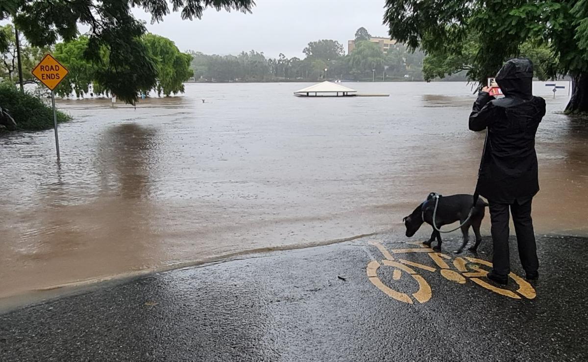
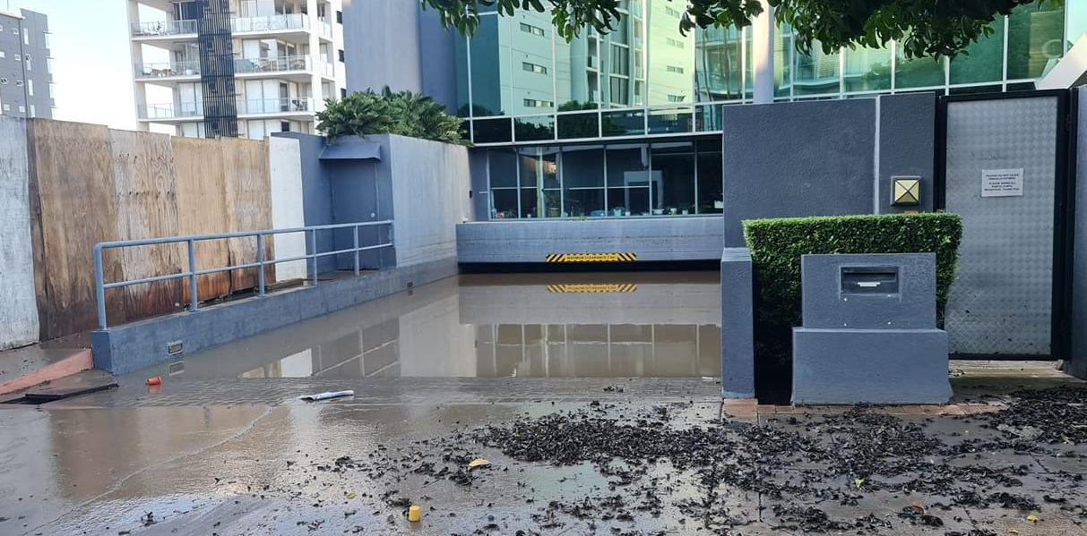
People’s phones pinged with the next flood and weather warnings. Vehicles were moved as basements were emptied. It rained from Friday 25th continuously until Sunday 27th, three days of torrential rain. Further warnings came and evacuation alerts. Gail Faux (CycloneGail on the Forum) shared her photos with us from Brisbane. She lost power and couldn’t get to work so was on 'Flood Leave' as the basements of her apartment block flooded.
There was coastal erosion as the seas churned with large waves, the outflowing water and damaging wind gusts. People watched the tidal changes along the River Brisbane, awaiting the next high tide. Brisbane woke to sunshine on Monday, although there were concerns of thunderstorms breaking out for the start of the new week. These would bring further flash flooding from surface water, although did materialise, even if the atmosphere was poised.
By Tuesday, a large portable generator arrived for Gail’s block to give basic power for lights etc but not for Air-Con. It is Australian summer so hot and humid. The noisy generator started pumping out the basements, an adaptive design feature to have the empty area under the living space. Also, the sludge and standing water smells. It will then need cleaning and sanitising. For a city built around the river, there has been a lot of damage to waterside businesses, homes and transport structures. It is also traumatic for people, the disruption and tension of the situation around them. The effects of flooding linger well after the rain stops.

Gradually the coastal low began to edge southwards although the threat of flash flooding remained from thunderstorms. Flood warnings continued into early March with eastern NSW then being hit by Major flooding as heavy rains affected the Sydney Basin and surrounding areas. Again, with already saturated ground and the low pressure continuing to draw tropical moisture-laden air off the sea onto the east coast. More rain is forecast as an active cold front swings in from the southwest at the weekend.
Brisbane photos by Gail Faux
Loading recent activity...