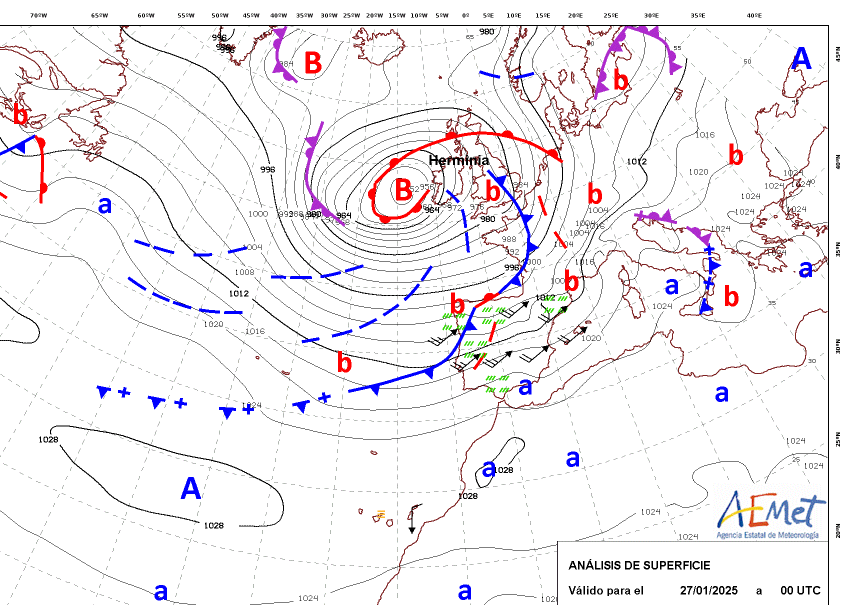
Low pressure will move slowly across the UK at the start of the week, Herminia, a storm named by the Spanish met service. UK gales for the far SW and a risk of flooding
We start the week with Herminia. This Atlantic low was named by AEMET, the Spanish met. service who are in a different naming group to the UK. Hence, why we have not moved onto Floris after Storm Eowyn on Friday with its red warnings for Northern Ireland and Scotland. This is not a widespread impactful windstorm, although SW Britain will see wild conditions at times and there are wider flooding concerns. Spain’s forecast for Monday includes widespread warnings of high winds, heavy rain, mountain snowstorms and stormy conditions for northern coasts and France has warnings too.
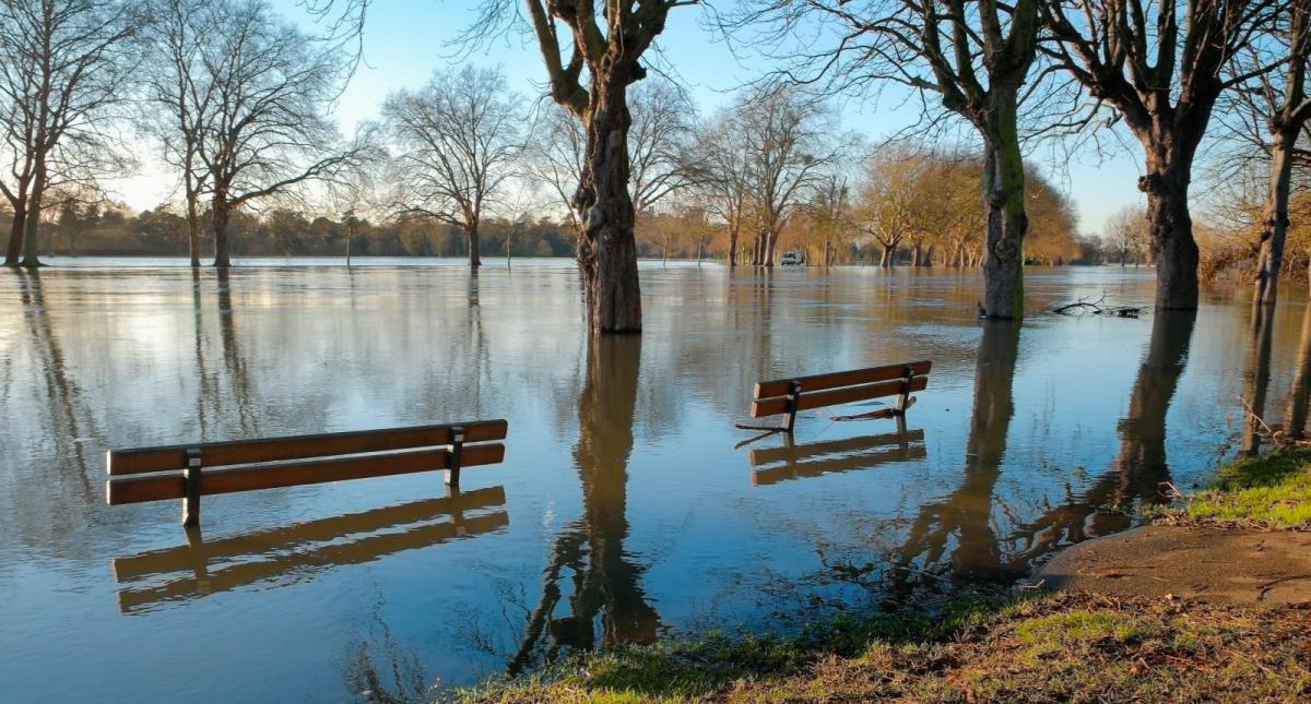
For the UK and Ireland, we could have just been facing a wet and windy Monday in winter, with squally showers, gales and heavy rain. However, the preceding wild weather from Eowyn and damage, along with existing saturated ground in the south means that as this low pressure sits over the UK for a few days, there will be further impacts.
There is a yellow wind warning over southern Britain and western Wales
“A period of strong and gusty southwesterly winds is likely to affect southern parts of England and Wales through Monday and at first on Tuesday...Winds will gradually ease from the west on Tuesday morning”.
It’s not a highly damaging and disruptive windstorm like Eowyn but there will be Low Impact winds with gusts of 50 to 70mph.
Looking at the Met Office warnings page, it’s quite hard to tell which yellow area links with which label but there are yellow rain warnings. One for today and tomorrow over the southern half of Wales and another for SW and southern England running into Tuesday morning
“Heavy, blustery showers and possible thunderstorms, will lead to some flooding continuing to affect roads”
SE Ireland also has a yellow wind warning for Co.Wexford as any more strong and gusty winds are likely to cause “Further damage to already weakened structures and trees. Dangerous travelling conditions.” Power outages continue across the island of Ireland from Eowyn.
Cornwall, Devon. Pembrokeshire and exposed English Channel coasts will see strong winds even gales this afternoon in Hermania and along the south coast overnight. The Inshore Waters forecast for Lands End to Lyme Regis includes “WInds- Southwest veering west or northwest later, 7 to severe gale 9”
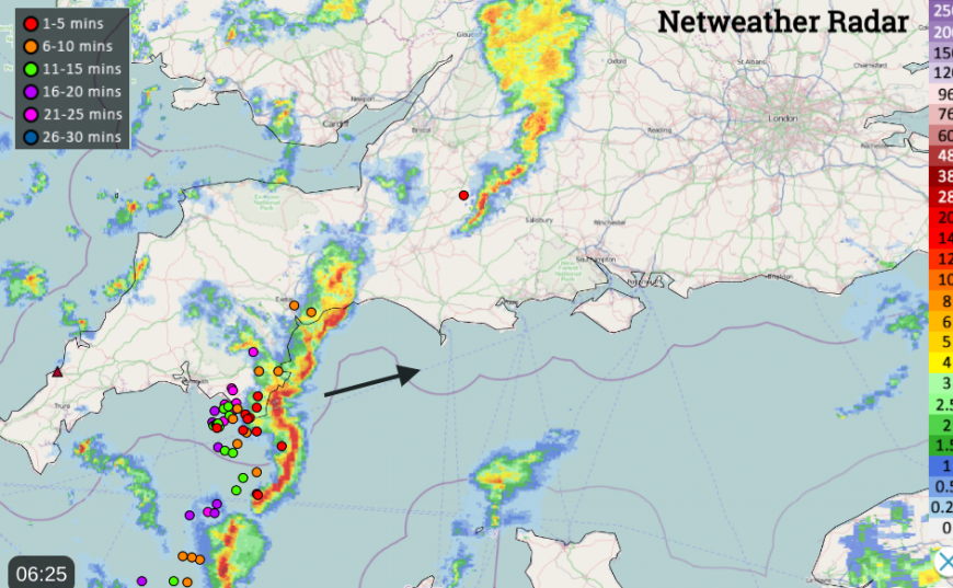
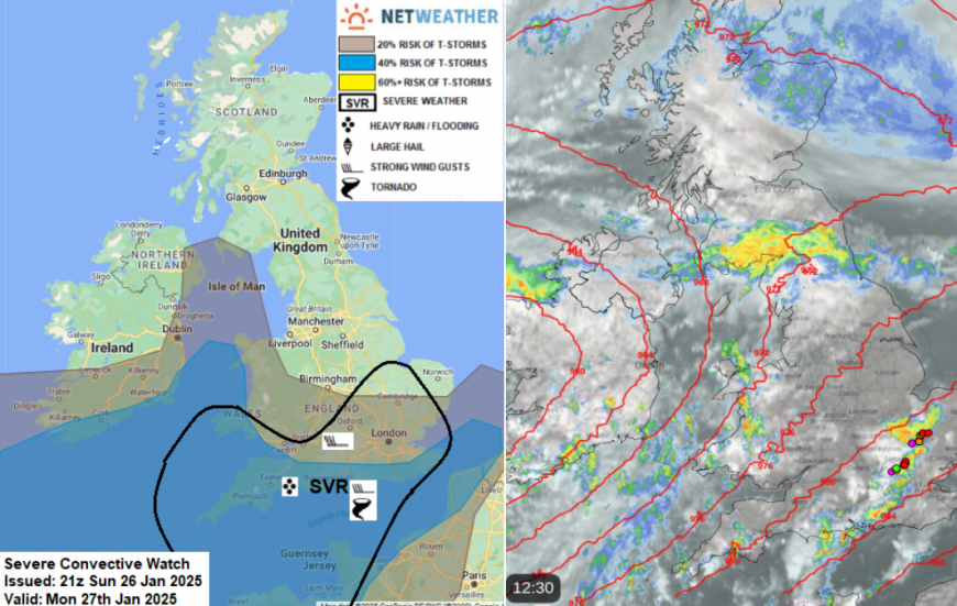
Last night there were squally lines across southern Britain with sudden loud winds, heavy downpours and hail. From the convective forecast
“Storm Herminia will produce an increasingly steep lapse rate over warmer seas to S and SW of British Isles. This will support heavy showers and thunderstorms - which will move in across southern and western areas of England and Wales on the strong SW'ly flow.”
Flooding concerns continue and there will be further hail and lightning on Monday.
The unsettled weather will rotate around the low with more hefty and thundery showers, an area of heavier rain over SW Scotland heading to the Central Belt turning wintry to the north for Perth and Stirling.
The heavy downpours will continue for Wales and SW Britain, pushing further inland tonight and gradually on Tuesday Low Herminia will move across eastern England. This shift will allow colder air over the UK from the northwest. There will be a lot of cloud about for Tuesday, outbreaks of rain and strong winds away from the low centre.
On Tuesday night the skies begin to clear away from northern Scotland where wintry showers continue to feed in. Most of the UK will be in the cold N/NW flow on Wednesday but there is some uncertainty around the little low pressure heading to the Brest peninsula. How far north will the frontal rain reach over southern England and how strong will the winds be affecting SW England in the middle of the day? Something to watch. France already has plenty of warnings for the wet and windy weather at the start of this week.
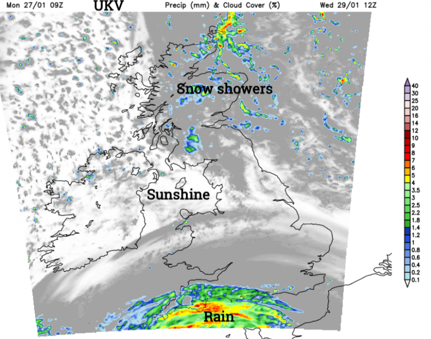
Other parts of the UK should see some sunshine but it will feel a bit cold. By Thursday, high pressure noses in from the Azores but doesn't stay put for long as fast-moving Atlantic fronts pile in from the northwest by Thursday night. The end of the week is then rather changeable as frontal bands rush in from the west with brighter or clearer spells in-between.
Keep an eye on the flood warnings this week as the risk of localised flooding continues over the next few days, mainly for southern England and Wales. This could be from surface water and along rivers, groundwater issues or coastal flooding in the strong onshore winds. Travel disruption is possible.
Loading recent activity...