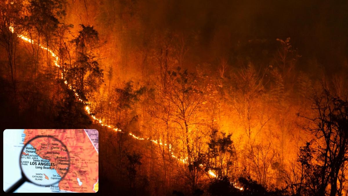
Five devastating fires fed by hurricane-force Santa Ana winds have killed at least 11 people and swept through 37,900 acres in the greater Los Angeles area, destroying entire communities and more than 12,000 structures. The firestorm began in the Pacific Palisades at 10:30 a.m. local time on Tuesday, but there have since been other fires sparked around L.A., including another major blaze, the Eaton fire in Pasadena, California.
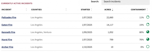
Evacuation orders for the largest blaze, the Palisades Fire, have expanded as it sweeps east and threatens Brentwood and Encino. Currently it is only 11% contained.
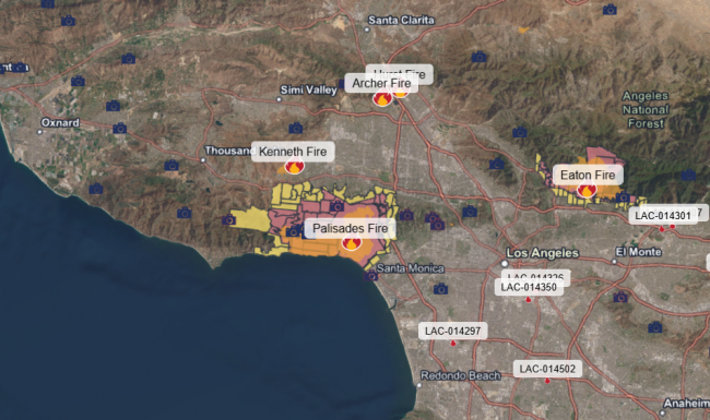
At least 153,000 Los Angeles residents were under evacuation orders this morning. Fire-fighting has been hampered by the loss of water pressure to local fire hydrants and the unavailability of water supplies from local reservoirs, with one closest to the Palisades fire apparently empty due to repairs. The Santa Ynez Reservoir had been closed since about February for repairs to its cover, leaving a 117-million-gallon water storage complex empty in the heart of the Palisades for nearly a year. Had the reservoir been online, water pressure in the Palisades would have lasted longer on Tuesday night, but only for a time. Experts have said that fully-functioning fire hydrants would still not have been enough to contain and control the wildfire that ravaged the Palisades.
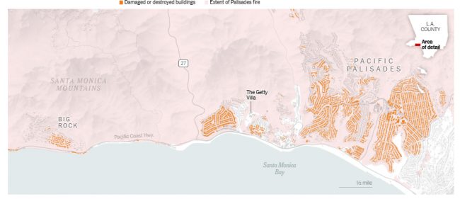
Map showing areas of damaged or destroyed buildings from the Palisades fire
Los Angeles County declared a public health emergency, warning that smoke and particulate matter could pose immediate and long-term threats.
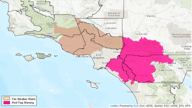
The National Weather Service has issued a new Fire Weather Watch for Saturday into Sunday for a large portion of Southern California. Strong gusty winds up to 45mph are forecast for The Inland Empire, San Bernardino County mountains, Santa Ana mountains and inland Orange County, said the agency, warning that any wildfires that start could spread rapidly.
Forecast Discussion for Los Angeles ECC Dispatch
415 PM PST Fri Jan 10 2025...EXTREMELY LONG DURATION OF ELEVATED TO CRITICAL FIRE WEATHER
CONDITIONS CONTINUING THROUGH THE MIDDLE OF NEXT WEEK WITH LITTLE
DAY TO DAY RELIEF......FIRE WEATHER WATCH IN EFFECT FROM SATURDAY EVENING THROUGH SUNDAY
AFTERNOON FOR GUSTY WINDS AND LOW RELATIVE HUMIDITY OVER MUCH OF LOS
ANGELES AND VENTURA COUNTIES......MODERATE TO STRONG OFFSHORE WINDS LIKELY MONDAY THROUGH WEDNESDAY
WITH A HIGH RISK OF ADDITIONAL RED FLAG WARNINGS OVER LOS ANGELES
AND VENTURA COUNTIES...Winds will shift to the northwest tonight, with gusts of 25 to
40 mph over the wind prone areas, including southwest Santa Barbara
County where a few hours of critical conditions are possible. The
winds shift back to northeast on Saturday and will strengthen
Saturday Night into Sunday when gusts of 35 to 50 mph will be common
over Los Angeles and Ventura Counties. Local gusts of 50 to 70 mph
are possible in some mountains. With continued dry conditions, Red
Flag Warnings are likely. While a brief reprieve from the winds are
expected Sunday Night, they will form again Monday through
Wednesday, with a peak around Tuesday of gusts between 40 and
60 mph. With humidities plummeting to 5 to 15 percent, there is a
high risk for Red Flag Warnings. Moderate confidence in relief
forming by Thursday with a 40 percent of light rain and light winds
for the end of next week.
Much has been made by some quarters that authorities could have taken some steps to potentially lessen the risk of wildfires. Inconsistent vegetation management, aging infrastructure and homes, and a lack of planning likely contributed to fires that have so far scorched more than 55 square miles.
However, much of what has made the fires so uncontrollable and spread so quickly has been out of the control of the authorities, as the fires have been fanned by dry and hot Santa Ana winds that blow out from the exterior deserts towards the Pacific coast and fed by dry vegetation, which grew in recent years thanks to high amounts of precipitation in the last few winters. However, this winter, the rains have not come during historically the wettest time for southern California, with no significant rain since last July in Los Angeles area.
All these conditions have created the ‘perfect storm’ of a situation in which Los Angeles is surrounded by lots of tinder-dry vegetative growth that has built up from recent wet winters. The fires are the result of a combination of suburban sprawl in fire-prone areas, fierce Santa Ana winds, dry conditions fuelled by climate change and the limits of firefighting.
The very strong Santa Ana winds made it more likely that any fire would grow quickly and have plenty to destroy. Longer term, these forces are also shaped by climate change, with California seeing occasional wet winters building up vegetation, but longer periods of drought and heat due to human-caused climate change, will mean wildfires could become more common and spread more rapidly.
Winter wildfires in southern California are often driven by the very dry Santa Ana winds, which sweep down mountain slopes and draw moisture out of coastal areas. The winds can rapidly push any fires that start, particularly when the landscape is dry. The air brought by Santa Ana winds has very low humidity – which provides the ideal conditions for wildfires to start and spread.
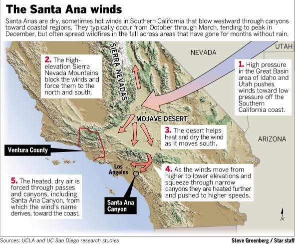
Typically, the San Gabriel Mountains trap high pressure, so the Santa Ana winds are produced as the pressure leaks through canyons and passes. But on Tuesday, the Santa Anas were able to cross the mountains and send a downslope windstorm toward Pacific Palisades and Pasadena.
Once the Santa Ana winds reach high speeds of 40-70mph, options to protect property are limited, as once the fire is ignited, there is no stopping it from spreading quickly through dry scrubland, forests and between houses often built with timber in populated areas, so there’s almost nothing that a firefighter can do other than create temporary barriers to allow people to evacuate.
There is no evidence to suggest that Santa Ana wind events are becoming likelier because of climate change. But rising temperatures and longer droughts mean a higher likelihood of conditions ripe for fire when the winds strike.
Loading recent activity...