
Storm Bert brought snow, ice, rain and strong winds over the weekend. Strong winds continue for Monday morning after a wild and weird couple of days due to severe weather, very mild air and Bert’s impacts. Five people are reported to have lost their lives in the deteriorating conditions on Saturday.
Heavy snowfall resulted as Storm Bert hit last week's cold, Arctic air. The snow and icy conditions lead to travel disruption in northern Britain with cancelled buses and incidents on the road network. The rain set in, starting over Ireland on Friday night where Met Eireann had issued red warnings for the heavy rain. There were flooded streets, and landslides as torrential rain continued. By Saturday, as the falling snow turned to rain, much milder air was pulled up from the mid-Atlantic and started a thaw of the lying snow from last week. Intense rainfall continued with some regions seeing around 80% of their entire average November rainfall in just 48 hours.

This caused surface water and river flooding with major incidents in Wales and Worcestershire and there is wider ongoing flooding today. Northampton railway station is flooded again and there is still disruption to rail services across the country. GWR has major disruption and Scotrail has speed restrictions in place due to strong winds. There is a severe flood warning on the River Nene near the A45 east of Northampton. The M32, M4, A66, A5 and A43 all have weather-related restrictions this morning.
Welsh First Minister Eluned Morgan has called the weekend flooding "absolutely devastating"
Monday morning saw two severe flood warnings in SE Wales on the River Monnow and numerous other flood warnings.
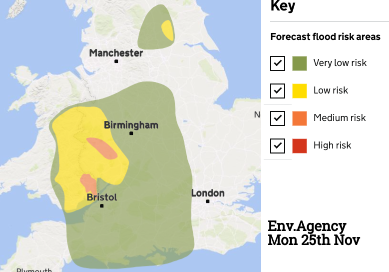
“Significant risk to life and significant disruption to the community is ongoing. River levels are steady. Severe impacts are ongoing in this area” Natural Resources Wales
SEPA the Scottish flood agency highlights that localised flooding from rivers and surface water is possible due to rain and also snowmelt and rough sea conditions around some coasts.
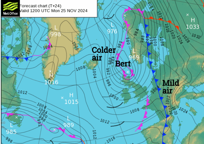
Strong winds added to the wild atmosphere at the weekend with a wind gust of 82mph in Snowdonia. One weather warning remains for Monday morning, a wind warning over Scotland and gales are forecast on Monday for exposed coasts and hills as Storm Bert begins to pull away on Monday.
Sunday was exceptionally mild. Santon Downham in Suffolk recorded 18.7C. After a warm day for western Europe, southern France reached 28C in late November and It was an extraordinarily mild night in Europe. Overnight temperatures, Sunday into Monday, reached the 20sC in SW France and northern Spain and the high 20sC for Morocco as Bert drew up incredibly mild air.
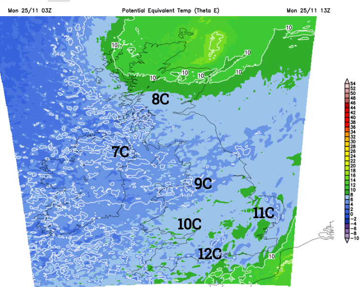
The airmass has changed for Monday. The mild air will leave SE England as cooler air from the northwest wraps around the outgoing low pressure.
This week will have drier days as high pressure tries to build over the UK. There is plenty of sunshine today away from the showers and rain over Scotland in the strong, gusty winds. There will be a scattering of showers for Wales and a few more coming into western Britain and Northern Ireland. By Monday night there will be clusters of showers scurrying in from the west but nothing like the rain on Saturday. The last of the strong winds will ease from northeast Scotland.
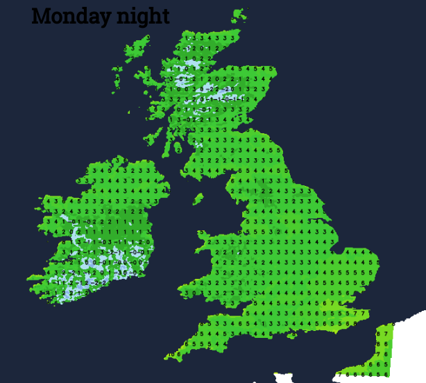
Temperatures will dip overnight, down close to freezing for some areas and after all the wet weather, there will be a bit of fog, and also frost for the cold spots.
Tuesday looks sunny and bright for many with light winds. There will be a few showers in the northwesterly flow. Tuesday night will be colder with a widespread frost away from the far south.
A small Atlantic low will interrupt the settled, quieter weather. There is uncertainty about the track of this low and where will see wet weather Tuesday night into Wednesday. The UKV has the low running across southern England with any heavy downpours along the south coast of England. The ECM model takes the low over more of southern Wales and Egnland, resulting in more widespread rain. To the north, there will be colder air with frost and the risk of freezing fog. If the low does shift further north, there could be wintry weather over northern hills. Around this midweek low, and as it pulls away from eastern England later on Wednesday, there will be strong winds.
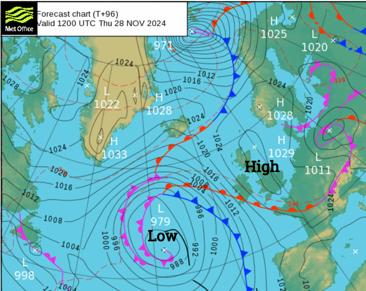
Wednesday will be quiet and cold with clear skies. Later this week a large Atlantic low begins to edge in, pushing up against the high pressure. A southerly flow will pick up bringing milder air to the UK. So temperatures will rise, it will become breezy and frontal cloud and rain will begin to edge in from the west. So plenty of temperature changes this week.
Loading recent activity...