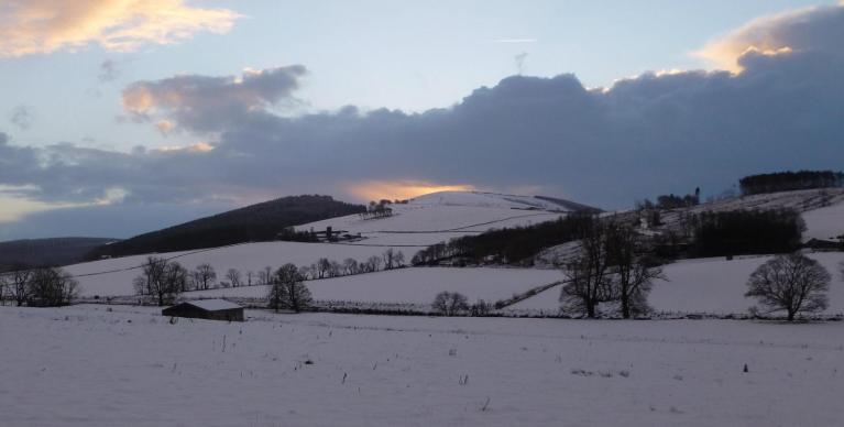
Like every year in the heart of autumn, winter weather enthusiasts start to become interested in the trends for the coming winter and whether it could be cold or mild. What will happen during the winter of 2024-2025? This is an early look using current trends…
Sarting with the different weather models seasonal output based on 1st October, there seems quite unanimous agreement that the start of winter 2024-2025 may frequently appear under the influence of high pressures, which follows on from the anticyclonic forecast by most models for late autumn too.
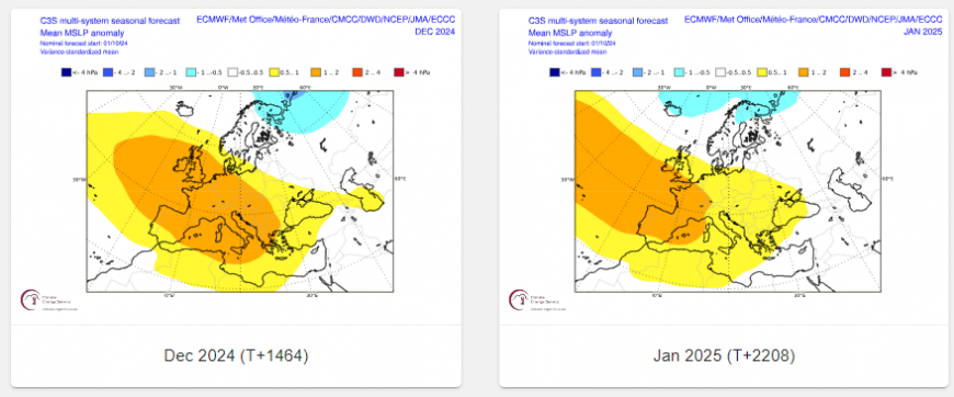
The Copernicus C3S Seasonal charts
This would mark a real break from previous seasons, often impacted by frequent low pressure systems off the Atlantic. But that might not last into the New Year.
In more detail, the month of December, a blend of the models generally point an anticyclone close to the British Isles, which suggests drier weather than normal. During the month of January, high pressure could recede slightly and give way to more typical weather with the passage of lows off the Atlantic close to or the British Isles. February would be in the same vein as January with zonal / unsettled weather dominated by low pressure.
C3S multi-model seasonal charts for mean sea level pressure anomaly for Dec-Feb

As well as weather model predictions there is a range of indices at our disposal, but in this blog I will deal with some of the most important of them which have the most impact on Europe indirectly (ENSO, QBO, solar) or directly (Atlantic SSTs). The coupling between these is also essential to know the weather regimes that are likely to occur.
There are two main categories of indices for the seasonal trend:
Seasonal: those which will allow us to draw up forecasts beyond 2-3 months such as the QBO, solar activity, ENSO.
Monthly: Those which have a more restricted range of predictability (1 to 2 month forecast) such as SST (Sea Surface Temperature), SAI (Snow Advance Index), MJO (Madden-Julian Oscillation).
In the case of this outlook, we will only look at the seasonal indices this far out at over a month away from winter starting.
ENSO (El Nino Southern Oscillation)
With regards to ENSO, the weather patterns of this year are partially controlled by the rapid end of the El Nino phenomenon in the Pacific Ocean, while its opposite, La Nina, takes over in next few months. ENSO is currently neutral, while current forecasts are for perhaps a weak La Nina developing through winter before returning to Neutral in February.

La Nina can bring two types of winters to Europe: either mild and wet, or cold and dry. But these different types are dependent on where the coldest SST anomalies of La Nina are situated over the tropical Pacific along with the status other major winter pattern drivers of QBO (Quasi-Biennial Oscillation) and position in the solar cycle. But other drivers closer to home need to be considered too, such as North Atlantic SSTs and their influence on the jet stream.
Quasi-Biennial Oscillation
The QBO is a regular variation of the winds that blow high above the equator. Strong winds in the stratosphere travel in a belt around the planet, and every 14 months or so, these winds completely change direction. It can affect the Atlantic jet stream. The speed of the winds in the jet stream weaken and strengthen with the direction of the QBO. When the QBO is easterly, the chance of a weak jet stream, sudden stratospheric warming events and colder winters in Northern Europe is increased. When westerly, the chance of a strong jet, a mild winter, winter storms and heavy rainfall increases. The QBO this winter is forecast to be westerly.

Solar cycle
Although the link is not robust, winters during solar minimum have an increased chance of being colder than average than those winters in the solar maximum, though there is normally a lag of a year after minimum and maximum when the increased chance or cold/milder winters is likely. We are now approaching solar maximum, due by July 2025.

Based on current forecasts for a central-tropical Pacific based La Nina cold anomalies, westerly QBO this winter and solar maximum it seems that, for this coming winter, the combination of these drivers will bring a predominantly mild and sometimes wet "zonal" flow through winter.
La Nina is a cyclical cooling of the surface waters of the tropical Pacific Ocean. It tends to cool the global climate too, but this will not happen instantly given the inertia of the atmosphere and especially the oceans. Thus, it seems quite likely that this year 2024 will be almost as hot as 2023, possibly warmer according to the World Meteorological Organization, before a possible slight, more perceptible drop in temperatures next winter, following La Nina development, albeit probably a weak and short-lived La Nina that may only last until next spring.
Also, despite the cooling of the central and eastern tropical Pacific, large areas of the northern Pacific are anomalously warm, some areas by a large margin. So, this larger scale warming over the North Pacific may mask the cooling affects of La Nina to something more akin of a neutral ENSO feedback on the atmosphere.
After a mild and rainy first half of autumn in the UK, there is a signal for to become less wet and perhaps even drier than average in November and perhaps December, thanks to more in the way of blocking high pressure, before more zonal and wetter flow returns again in January and February. However, it looks to remain predominantly mild, in the UK and across much of European, except in northern Scandinavia.
Remember that these seasonal forecasts are not forecasts strictly speaking, they constitute a trend, based on the analysis of the predominant signals from certain weather models. At this time, factors may intervene and modify this trend, in particular the behaviour of La Nina: this will be the climatic parameter to follow carefully in the coming weeks, and which could lead to possible changes in the final winter forecast – which will be issued late November.
Loading recent activity...