Netweather
GeoLocate
GeoLocate
Snow?
Local
Radar
Xmas

Storm Ashley Arrives: A wild end to the weekend for some

Storm Ashley has arrived and will bring some wild winds to Ireland, and North and Northwest of the UK, in particular. It will move through, past the north of Scotland, overnight and into the early hours of Monday.


Issued: 20th October 2024 11:47
Updated: 20th October 2024 12:07

After rapidly deepening in the Atlantic yesterday, Storm Ashley is now on the scene to bring a wet end to the weekend for many of us, and a very end to the weekend for those in the North and West. 

Following an initial burst of strong southerly winds arrived first thing, the next bout will move in from the west during the remainder of the day as the low approaches with gusts of 60-70 mph in exposed parts of Northern and Western Britain (from Wales northwards), and the potential for even higher gusts in northwest England and Scotland - particularly, but not neccessarily exclusively in the west.

The bands of rain which arrived overnight, will continue to move through to the east during the remainder of Sunday, clearing eastern England during the afternoon. Further heavy downpours, sometimes merging into longer spells of rain will move across Ireland and into Scotland though, with some of those making it down into Northern England and Wales. 

Met Office warnings for both wind and rain have been issued - including an Amber warning for wind in western Scotland where gusts in excess of 80mph are possible. 
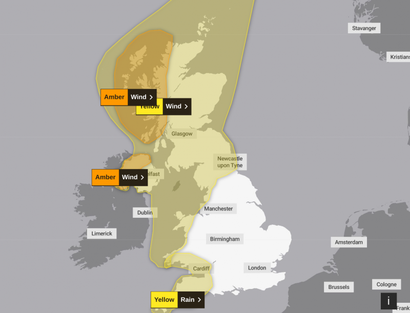
Met Office warning map

As the low pressure system moves past Northern Scotland overnight tonight, it'll begin to fill (weaken), allowing the winds to slowly ease down, but they'll remain gusty and strong in the north and east of Scotland until Monday morning. 

Monday will be calmer, but still on the blustery side across the northern half of the UK. There'll be 3 main zones of weather, some persistent rain may affect the far southeast, heavy, blustery showers will continnue to blow through into Scotland, Ireland and the far north of England. In between it'll be drier and brighter with a scattering of showers which will mostly affect western regions. 

Recent Posts

40mm of rain here so far this month - I'd call that fairly damp! I set a new low for solar output from my 8.8kW of solar panels yesterday; 300Wh all day. A sunny winter day should see 20,000Wh. I'm not expecting today to be any better. There is no...

In Absence of True Seasons maybe it's about making the most of it too. I get a buzz this time of year, because at work I'm dropping off lots of lovely Christmas gear at people's houses, and there's a general aura of build up to Christmas. The roads...

GFSP29EU00_288_2.png

Personally I like Member 29 at day 12. If only we could discuss these charts within the 5-day time frame.

AO-
AO- | 9 Minutes Ago

Straight to day 10 charts at the moment with the familiar problem of too much energy in the tPV near Greenland flattening any ridge attempts.

Still an outside chance of getting lucky on Christmas Day for the usual wishbone areas.

Not sure about on here, but I remember finding a Reddit thread a little while back of someone complaining about how dull and wet 2024 is. Many of the replies were essentially "Speak for yourself, I like this weather because its cozy" or "But its so...

GFSP03EU00_288_1.png

Good Morning all,

Very quiet this morning, but that is no surprise regarding the output. Having a glance at the first half of the members of GFS on the day before Christmas, there is a wide variety of options available. From Ural blocking to a zonal...

AO-
AO- | 16 Minutes Ago

Site Search

Connect with us
facebook icon Netweather on Threads Netweather on Instagram Netweather on Bluesky
...Or you can join the friendly and lively
Legal Terms - Privacy Policy - Consent Preferences