
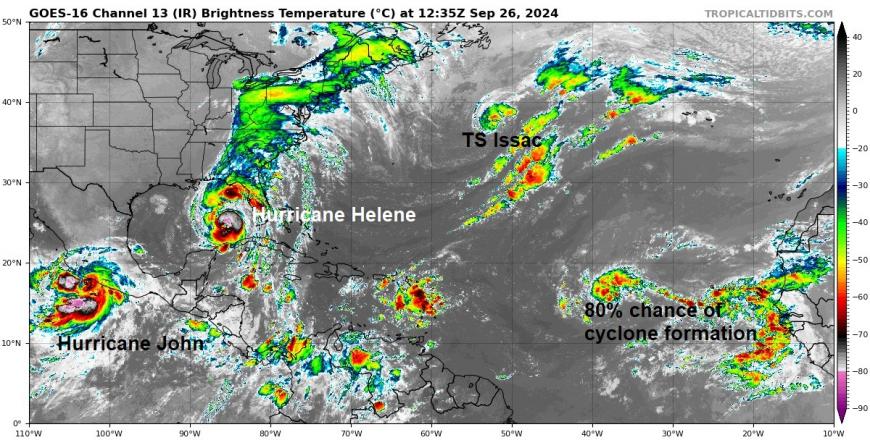
Parts of the United States and Mexico are reeling from Hurricane Helene and Hurricane John. Both brought damaging winds but extreme rainfall and devastating flooding caused wide-reaching destruction. For the Southern Appalachian mountains and the south coast of Mexico, the muddy or watery scenes look almost unrecoverable.
New storms continue to form. Hurricane Isaac has moved to the North Atlantic and changed to a post-tropical low linked to heavy rain over northwest Iberia. Tropical Storm Joyce meandered around mid-ocean only troubling fish but Hurricane Kirk is one to watch here in the UK. This cyclone is forecast to move eastwards across the North Atlantic, transitioning into a post-tropical low (so no longer a hurricane) but could bring a bout of very wet and windy weather next week.
Mexico
Hurricane John was on the Pacific coast of Mexico and made two landfalls in late September whilst depositing historic amounts of rain. The southern coast including Acapulco was hit hard, still recovering from the destruction caused by Category 5 Hurricane Otis in October 2023. It was the slow-moving nature of John that added to the devastation as the cyclone meandered about dumping more and more rain. Helene also impacted the Yucatan peninsula before heading to Florida's Big Bend.
The 2024 Atlantic season
Record-breaking Category 5 Hurricane Beryl “caused unprecedented devastation across the Caribbean, making its destructive path through Saint Vincent and the Grenadines, Grenada, Dominica, Barbados, and Jamaica” (ReliefWeb) in early July after impacting Barbados. It left disaster zones in its path with ongoing needs for essential psychological support. THere is a “critical importance of addressing mental health needs at the same time as immediate rebuilding and recovery needs.”
Hurricane Debby in early August was a category 1 but “Debby's torrential rainfall triggered widespread flash floods and river flooding across the southeastern U.S., especially from Florida to the Carolinas… while Charleston recorded rainfall totals as high as 15 inches.” NOAA
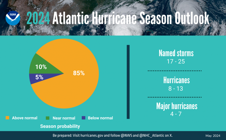
The May NOAA forecast for the upcoming Atlantic hurricane season highlighted “expected to have above-normal activity due to a confluence of factors, including near-record warm ocean temperatures in the Atlantic Ocean, development of La Nina conditions in the Pacific, reduced Atlantic trade winds and less wind shear, all of which tend to favour tropical storm formation.” Early in the season, the SSTs (Sea Surface Temps) were near record warmth helping Beryl to intensify readily. La Nina is not here yet.
The BoM (Australian Bureau of Meteorology) climate driver update from 1st October shows “The El Niño–Southern Oscillation (ENSO) is neutral “ and “While some atmospheric indicators such as pressure, cloud and trade wind patterns over the Pacific have been more La Niña-like over the past few weeks, there has yet to be a consistent/sustained signal. Should a La Niña develop in the coming months, it is forecast to be relatively weak (in terms of the strength of the SST anomaly) and short-lived”
The peak of the Atlantic hurricane is usually August to October with September the 10th as the statistical high point for activity.
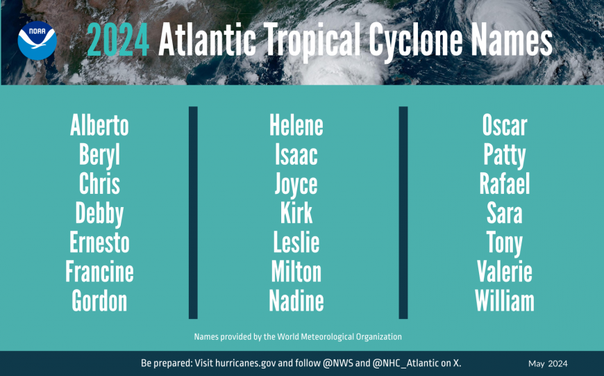
Early October, and we're up to K for Kirk. Due to the remote nature of some inland areas ravaged by flash flooding in Hurricane Helene, the full story is only just appearing. Routes have been washed away in North Carolina further hampering aid efforts, CNN is reporting that at least 130 people across six states have died with hundreds more unaccounted for. Power and water supplies along with communications are in tatters. The unreliable cell phone networks are causing concerns for families who can’t contact relatives. Initial clearing of debris has begun but the sludge left behind will take months with some areas being destroyed in the torrents.
Before landfall, the focus can be on where and when, which hurricane category for windspeeds. As we’ve seen with Helene and John, intense rainfall can be destructive and deadly, as can the storm surge around coasts such as the Gulf of Mexico. Preparation and reliable communication of warnings is key.
Some cyclones make their way inland over the United States, weakening once cut off from their warm water source. Others head northwards over the Atlantic, like Hurricane Ernesto moving from Puerto Rico to Bermuda in mid-August and then close to Newfoundland before finally transitioning to a post-tropical low.
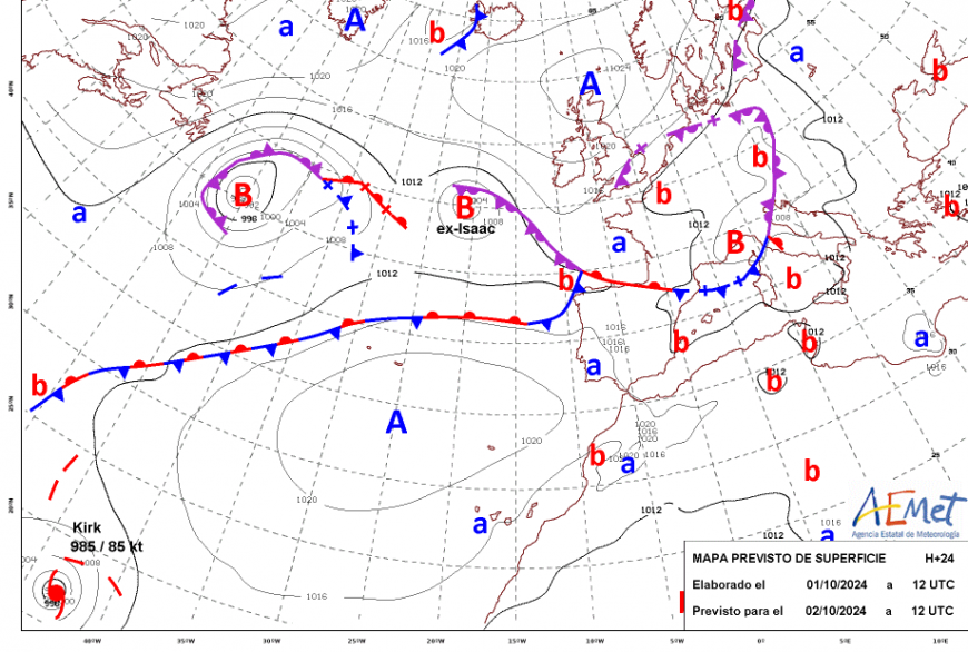
Hurricane Isaac made that transition earlier this week from Tropical to extra-Tropical low. A secondary low formed closer to Iberia and the weather fronts from this have resulted in heavy midweek rain for northern Spain and northern Portugal. Sometimes these tropical systems affect our European weather, even the UK’s, as a lively autumn low pressure with a bit of tropical oomph mixed in. The remnants of Isaac will be swallowed up by another Atlantic low pressure which will bring blustery conditions to the UK at the weekend with clusters and bands of heavy showers but a mild southerly airflow.
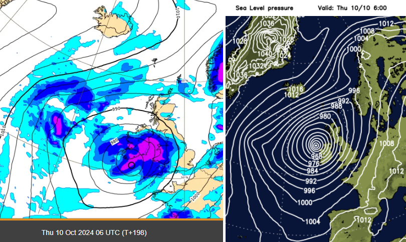
Post tropical Kirk showing on the ECM and GFS models later next week
Hurricane Kirk is catching the eye, showing a significant (extra-tropical) low pressure on weather models next week close to SW UK. Currently, Kirk is mid-Atlantic Ocean between the Cape Verde Islands and the Lesser Antilles. After strengthening to major hurricane status still mid-ocean, by Monday it will be much further north, between the Azores and Washington DC. Various models then take the cyclone eastwards. After all the heavy rain that southern Britain saw in late September, the unsettled autumn weather won’t help at all.
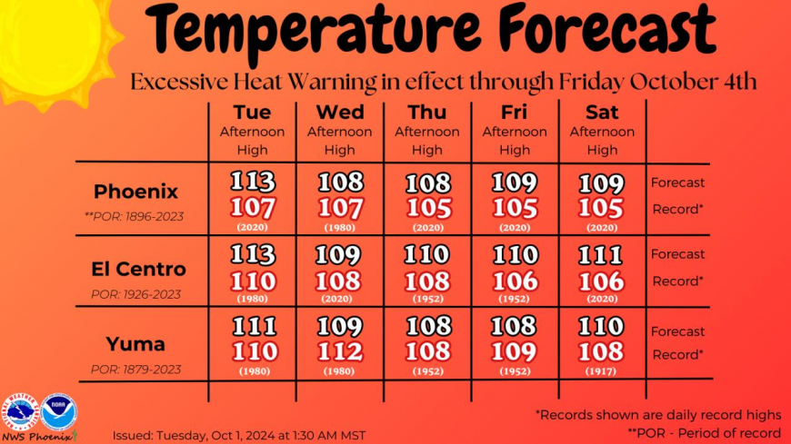
Meanwhile, in Arizona, there has been record-breaking heat. Western states have been experiencing hot weather recently but Phoenix broke its October month temperature record by 6 degrees Fahrenheit on the 1st. There has been abnormal heat for over a week with the very hot conditions forecast to continue into the weekend “as persistent high pressure remains parked over much of the Western United States”. 107F is 41.6C and 113F is 45C
@NWSPhoenix The high temperatures today at both Phoenix and Yuma reached 113°F. This not only breaks the record high temperature for the date at both sites, but it also is the highest temperature ever registered on any day in the month of October. #azwx
Loading recent activity...