As well as parts of central and eastern Europe experiencing record-breaking rainfall and snowfall over recent days, coastal parts of the Carolinas along the eastern seaboard of the US have also seen unprecedented rainfall and subsequent flooding.
There is a similarity between these two extreme rainfall events in that a wavy jet stream and blocked pressure pattern has led to weather systems becoming stuck. Storm Boris low pressure system became stuck over SE Europe from late last week through the weekend.
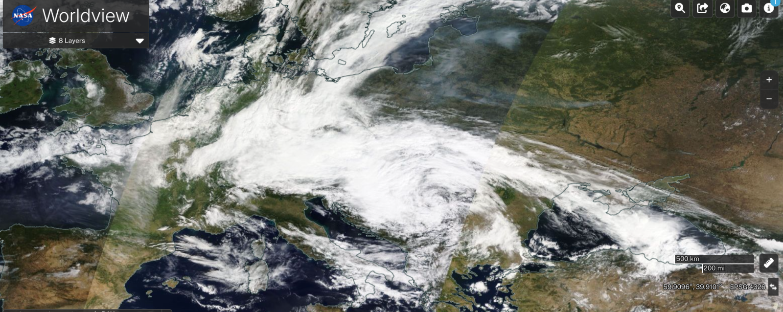
Storm Boris formed over northern Italy early last Thursday, as unusually cold arctic air for September swept south into mainland Europe, moved over the Alps and met with warm and humid air from the Mediterranean. The low then moved east over SE Europe, but then became stuck over the weekend due to slowing of the upper flow pattern. This is because an upper trough in the wavy jet stream, which flooded western Europe with cold air last week, stalled from wave-breaking and disrupted into a cut-off upper low aloft, in effect cutting off a low pressure circulation from the main upper flow, keeping the low pressure system trapped in situ for a while.
Upper trough disruption over Europe, followed by cut-off low becoming slow-moving over SE Europe, leading to persistent heavy rain on the stalled frontal zone on northern side over central and eastern Europe:


Cold arctic air on the western side of the low and warm and humid air on the eastern side met along a slow-moving frontal system sitting over Austria, SE Germany, Czech and Slovak Republics and SW Poland. The large contrast in airmasses led to copious rainfall along the boundary, as warm humid air was forced upwards by the denser cold air at the surface and also orographic lift of mountains of eastern Europe and Austrian Alps.

Parts of Lower Austria in the north of the country, the mountains in northern and eastern Czech Republic and over into bordering SW Poland saw over 400mm fall from the rainfall event. To put into context, St Polten in northern Austria saw 419mm fall during the event, the average rainfall for the town for the whole of September is 80mm, while annual rainfall is around 814mm per year, So the town has received five times the average September rainfall and half the average yearly rainfall over the space of 5 days! Similar excessive rainfall departures from the average have been recorded across stations in northern and eastern Czech Republic, SW Poland, Romania and Slovakia

Not surprising that rivers emptying the catchment areas of the aforementioned areas have been causing catastrophic flooding, particularly in the Czech Republic and Poland, submerging entire neighbourhoods and forcing hundreds of thousands of people to evacuate. Water levels downstream of rivers draining where the highest rainfall fell are not expected to peak for several days, with the Danube river level yet to peak in Budapest in Hungary and later on further downstream through communities along or near the river in Romania.
Over the pond in the USA, roads and cars disappeared underwater as a tropical rainstorm, officially named potential tropical cyclone 8, dumped up to 22 inches of rain in 48 hours across parts of southeast North Carolina up to the end of Monday. Rainfall rates of 4-5 inches per hour overwhelmed drainage systems and caused widespread flooding in Brunswick and New Hanover counties.
Low with nowhere to go over SE USA last Monday = huge amounts of rain over coastal N Carolina.


Again, an atmospheric blocking pattern across North America was responsible for slowing down the tropical system as it approached the eastern seaboard off the Atlantic. Potential Tropical Cyclone Eight, previously known as Invest 95L, formed off the Southeast U.S. coast last Sunday, the disturbance was steered towards the coast of the Carolinas on Monday on the southern side of a blocking high over northeast USA. However, the low was blocked by the high to the north with no escape route, so moved very slowly as it approached the coast. And with a continuous feed of tropical moisture from the southeast, the system dumped the historic rainfall in an area of coastal North Carolina.
The weather pattern remains blocked over Europe this week, with a blocking high over northern Europe and upper lows over southern Europe. One of these upper lows will become slow-moving over Italy the next few days, before it drifts northwest towards northern France on Friday. The slow-moving upper low will have cold air in the mid-levels, which contrasting with very warm and humid air at the surface, with sea temperatures in the Mediterranean around 23-25C, will create a very unstable atmosphere.

This will support intense thundery downpours across Italy and over neighbouring islands of Corsica and Sardinia today and tomorrow. Over 100mm could fall in places in a short space of time, particularly in Emilia-Romagna, Marche and Abruzzo regions of northeast Italy. So there is risk of flash-flooding in these areas. Red warnings have been issued for the Emilia-Romagna region.
Loading recent activity...