The heat will be gone by Friday; just holding on in eastern and southeast England on Thursday.
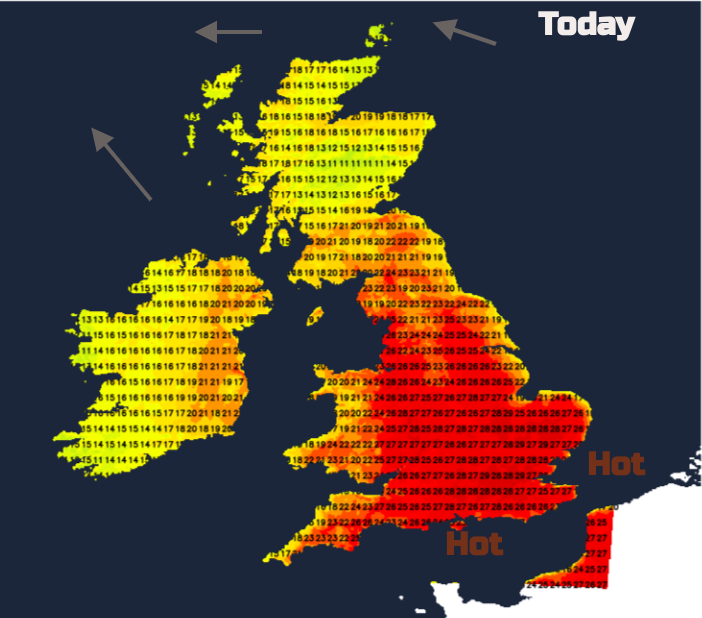
Yesterday, the top UK temperature was 30.0C for Chertsey in Surrey and 31C is possible today (Weds) in London or inland eastern England. Much of England will be in the 20sC. Manchester, Birmingham and Southampton up to 28 or 29C, Newcastle 20C. Northern Ireland and Scotland could see 20 to 23C in places. Wales will widely be in the 20sC, perhaps reaching 29C. Grass and weed pollen levels remain high and there are concerns about the air quality with hardly any breeze.
Air pollution forecasts mention “increasing amounts of Moderate pollution across many parts of England and perhaps Wales” DEFRA
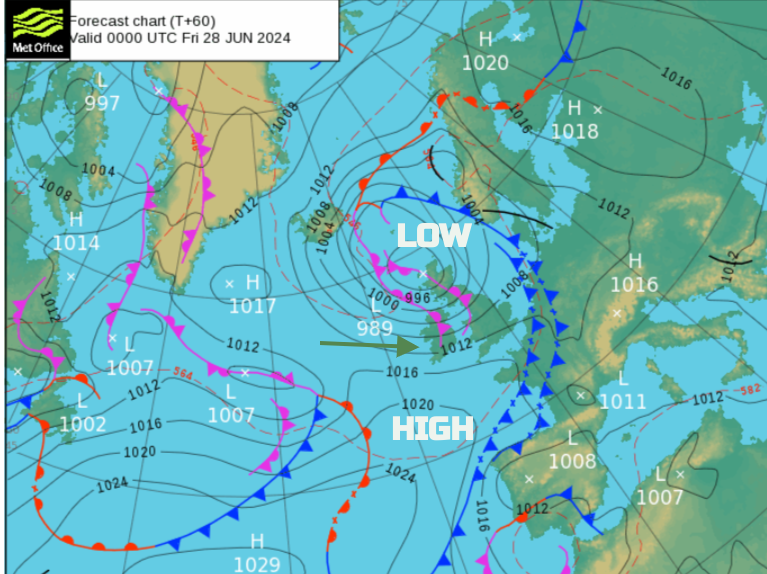
Change is on the way as a low pressure slips in from the north Atlantic to the north of Scotland. Cooler, fresher air is already over Northern Ireland and much of Scotland where there was a stunning display of noctilucent clouds last night, for those with clear skies. Glasgow around 18C, perhaps higher in sunny spells. The low pressure will direct the fresher feeling air right down through the UK by the end of the week and across northwestern Europe.
The Yellow Heat-health alert continues, in effect from 24 June 2024 at 08:00am to 27 June 2024 at 05:00pm. This service warns the health and social care sector that "minor impacts are probable" with an increase in demand. Also in issues as indoor environments become very warm.
There aren’t any weather warnings. We are seeing temperatures in the mid to high 20sC but the UK record from July 2022 was 40.3C. The UV levels are high at this time of year in the strong June sunshine. People tend to take care in the heat. Later this week it will feel fresher for more of the UK with a different airflow and blustery winds. The UV levels, in any sunny spells, remain high but people can be caught out and can burn as it doesn’t feel as hot.
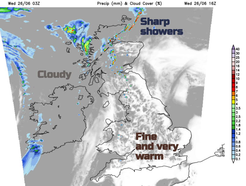
Showery rain will brush over Northern Ireland today where there is a lot of cloud. SW Scotland has already seen showery rain but temperatures rising in any sunny spells. Mostly, it is cool and cloudy further north with more showers breaking out this afternoon. These will become heavy so a very different picture to the ongoing heat and strong sunshine further south.
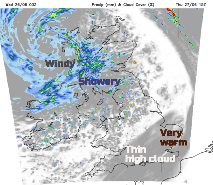
Frontal bands from the low pressure will reach western Britain tonight. There will be thicker cloud and outbreaks of rain, including for Somerset early on Thursday. The forecast for Glastonbury is not too bad. It won’t be as hot and there should be a good deal of fine, bright and dry weather about for the festival. It will be quite blustery, the flags will be fluttering with temperatures of 17 to 20C.
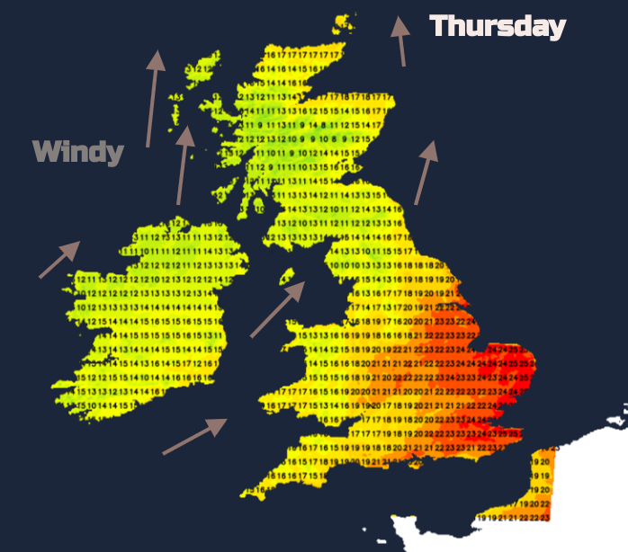
The frontal band over Britain should fade on Thursday with a very warm day for eastern England down to Kent as temperatures reach 25 to 28C here. Western areas will feel much fresher in brisk southwesterly winds with rain for Northern Ireland and western Scotland on a windy Thursday. Areas to the lee of high ground could do quite well, up to 20C for Moray and north Aberdeenshire thanks to the Fohn Effect.
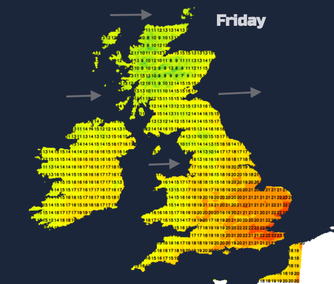
By Friday temperatures across the UK will be 15 to 21C. Northern areas will be windy with showers passing by and bright spells. Further south it will be fine with sunny spells but without the heat.
Take care of your dogs in this hot weather
Loading recent activity...