
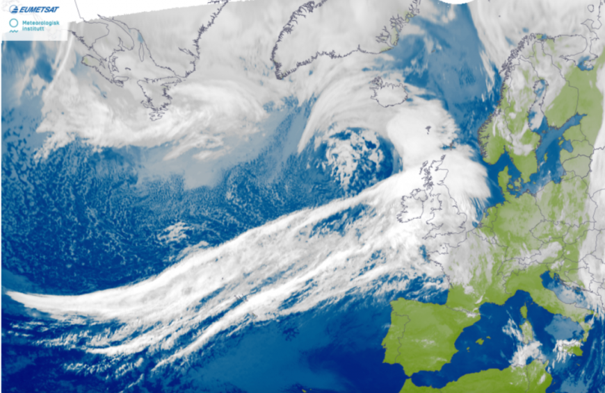
Hot on the heels of Sunday’s Storm Isha is Storm Jocelyn. A large Atlantic low which is wide in its own scale and cloud shield but is not forecast to cause as widescale disruption as Isha. However, more rain will lead to flooding concerns and another wild night for northern Britain on Tuesday night with further disruption on Wednesday morning.
The UK Met Office has already issued an Amber wind warning for northern and western Scotland including Orkney
“potential for gusts of 75 to 80 mph in a few places, particularly exposed parts of the Western Isles and coastal northern Scotland.” MO
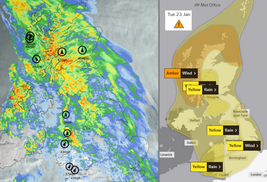
Netweather Radar at 10:35am Tues 23rd and Met Office weather warnings
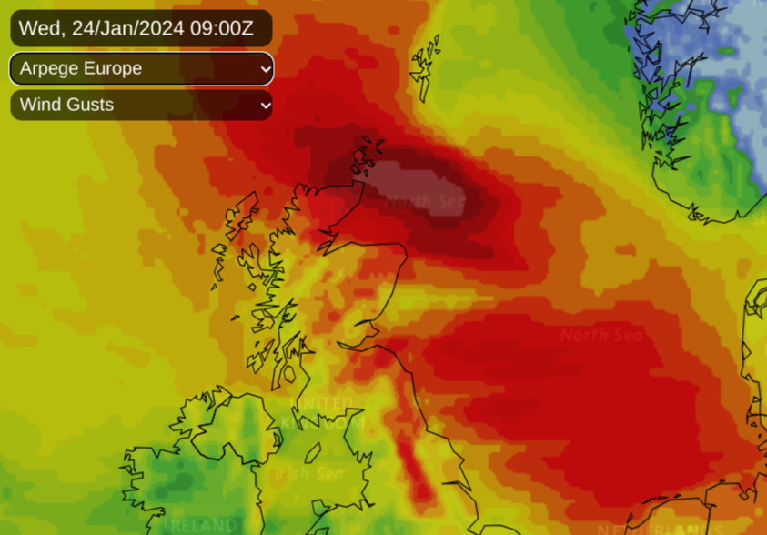
There are wider yellow wind warnings over Northern Ireland, Scotland, northern England, the Midlands and Wales along with more specific rain warnings. Ground conditions were already soggy before the cold week and the weekend’s rain. Now the Atlantic fronts are bringing further downpours from the west and snowmelt is adding to the water levels.
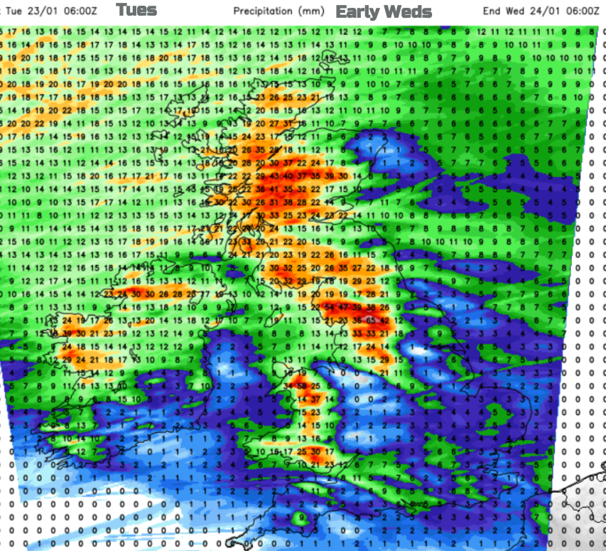
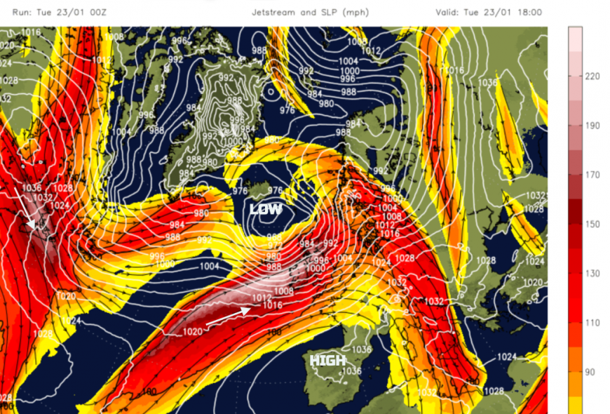
Ahead of Storm Jocelyn’s cloud cover, there has been a cool start for somewhere clear skies lasted with temperatures down to around 3C. JOcelyn’s warm front rain is already reaching the UK from this more classic structured low which is maturing. It’s explosive deepening took place out over the Atlantic, whereas Isha was still rapidly deepening as it got near to northern Scotland with concerns that extreme damaging winds could have been drawn down to the surface, However, this next bout of rain and gales will only add to the existing conditions. The ground has been saturated for months, and Isha will have weakened other trees and structures which is not ideal before another wild night. Also, the quick turnaround between lows means that there has only been a short window for power and railway line repairs. Issues or cancellations are showing on every Calmac ferry service along west coast Scotland and Scotrail have already stated that rail services will cease again at 7pm on Tuesday and not resume on Wednesday morning until checks have been completed.
“Storm Isha has caused extraordinary ongoing damage to the railway…routes are still closed pending line safety checks/repairs” ScotRail
It will feel mild within the warm sector out of the breeze and rain with temperatures in double figures. The southerly winds will veer to the southwest and freshen. The cold front rain will move across the UK this evening followed by hefty showers wrapping around the low centre.
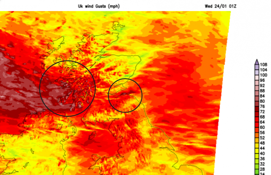
The SW winds will strengthen this evening with gales even severe gales in exposure off the Irish Sea to Cumbria, Snowdonia and northern Pennine routes. Also western Scotland later this evening. The UKV model has a core of severe gales, possibly storm-force winds for the west coast of Scotland. Strong westerly winds, gales and high gusts will affect central western Scotland, Arran, maybe clipping the north coast of Northern Ireland, and funnel through the Central Belt to the Forth Valley around 4am. Another pulse of stormy weather looks to reach Orkney by 8am, possibly Shetland too so further disruption here.
Wednesday remains windy for northern Britain as the core of the storm moves out over the North Sea. The inshore waters forecast from the Met. Office mentions High Seas and Storm Force 10 for the west coast of Scotland, and Orkney tomorrow. Also severe gale for the Irish Sea this evening.
We are up to J on this season’s storm naming list. Jocelyn was named by Met Eireann for the forecast severe weather in Ireland midweek. This storm will also impact the UK. It is named after Jocelyn Bell Burnell, an Astrophysicist who discovered the first pulsar (a spinning star made up of neutrons) and was the first female president of the Institute of Physics
The names are preset on a new list that appears each September. The UK, Ireland and the Netherlands are in one group (there are others in Europe).
Last year we only used A and B, Antoni and Betty as the jet stream took a host of low pressures further south, impacting France and Spain, who are in a different naming group. They reached P for Patricia, which shows how the focus of significant low pressures can vary annually. Storms are usually named in autumn and winter but some summer events can also be named.
When the jet is strong and develops a storm, often another one will follow as the ripe conditions are already there. Jocelyn followed Isha and back in February 2022 Dudley, Eunice and Franklin appeared in under a week. For the UK this week, we will continue with the theme of windy but fairly mild conditions with more rain from the west.
More discussion and chat Storm Jocelyn in the Netweather community forum
Loading recent activity...


