Winds are turning northerly across Scotland, bringing arctic air down across the country and increasingly wintry conditions – with snow showers arriving in the north, even to lower levels. This arctic air will sweep south across all of the UK by the end of Sunday with the cold arctic airmass looking to linger through much of next week.
Snow showers for N. Scotland, N. Ireland western and eastern coasts exposed to the northerly wind for much of the week, though more organised spell of snow likely moving across the north on Tuesday.
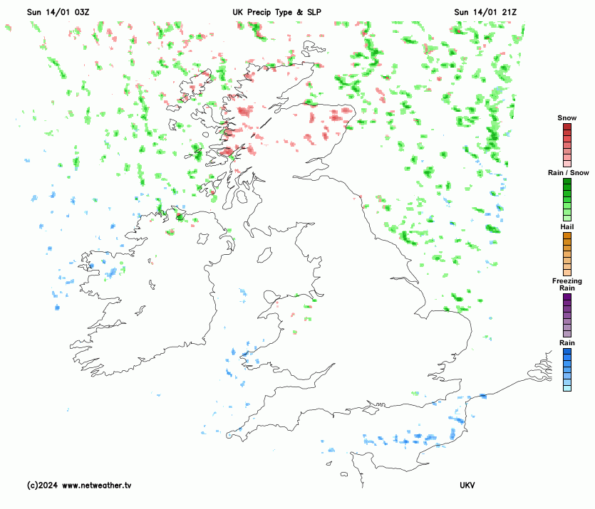
As a result, temperatures will reach low single figures at best during the day with widespread hard overnight frosts where skies remain clear. There will also be some snow, initially across northern areas early next week, falling from showers across the north of Scotland, along western and eastern coasts through much of the week, some getting inland in places. A more organised area of snow, associated with an area of low pressure moving southeast across northern areas, could bring some disruptive snow to parts of central and southern Scotland and the north of England. Also a band of snow may reach southern England on Wednesday, but low confidence on this.
This is a map where I think there is low, medium and high risk of disruptive snowfall this coming week
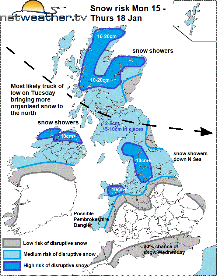
The Met Office have snow and ice yellow warnings in force for: northern Scotland today and Monday, whole of N. Ireland on Monday. Tuesday there is yellow warning for snow and ice covering all of Scotland, all of N. Ireland, the far north & northwest of England along with north Wales. Wednesday and Thursday there is a yellow warning for snow and ice covering the north and far west of Scotland, the northern half of N. Ireland, parts of NW England, north and west Wales.
A more organised area of snow is signalled to move southeast across parts of Scotland, N. Ireland and northern England on Tuesday. A secondary area of low pressure developing to the south of Iceland, in the cyclonic arctic flow on the western edge of large upper trough over Scandinavia, is forecast to track southeast towards northern Britain on Tuesday. This low and its associated fronts look to bring a spell of snow southeastwards across parts of Scotland during the day, most likely central and southern Scotland along with, N. Ireland and northern England. Snow may turn to sleet or rain across N. Ireland and western coastal areas of Scotland and NW England, as less cold air filters in off the Atlantic.
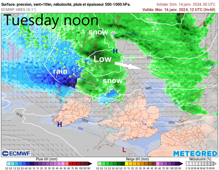
This spell of snow affecting northern areas Tuesday could bring several centimetres in places, especially over higher ground - with potential for disruption. Snow showers Monday ahead of Tuesday’s more organised snow across northern Scotland and near western and eastern coasts in the north could give a covering near coasts and 5-10cm inland across northern Scotland.
Following Tuesday’s spell of snow moving across the north, further snow showers will spread south for the rest of Tuesday across the north of Scotland, the north of N. Ireland and down along eastern and western coastal areas of Britain, perhaps getting inland across western areas where winds back more northwesterly.
Generally inland areas of Britain away from the north and windward areas towards western coasts tending to stay dry and sunny, the so called ‘wishbone effect’ typical of northerly flows. There could be one or two troughs that bring showers further inland that aren’t being picked up by models, but if they occur, they won’t be picked up until nearer the time.
Potential for area of snow to move into southern England Wednesday, but low confidence for now
There has been hints for a while from models for an area of low pressure originating near the Azores to move towards NW Europe mid-week. Some model runs recently have brought an area of rain with the low towards southern England, turning to snow as it bumps into the cold air in place. Most models did back off the idea of bringing a band of snow in across southern England for a few days, rather it moves over northern France, but recent GFS and ICON operational runs have brought snow back in across southern England, for now. ECMWF and UKMO keep snow over English Channel or France, but both have shifted further north compared to their previous runs. But low confidence on this, would deem it a 30% chance to happen for now.
Otherwise, it’s looking likely snow showers will continue to affect northern Scotland, the north of Northern Ireland, and western and eastern coastal areas further south exposed to the north to northwest wind, as far as SW Wales in the west and East Anglia in the east. Snow showers may get inland across the west, when wind back northwesterly, such as through the Cheshire Gap. Some local accumulations are likely from these.
Thursday & Friday
Snow showers over northern Scotland and around coasts which, will perhaps occasionally move inland, continuing Thursday. On Friday, models indicate a ridge of high pressure building in, which will tend to kill off snow showers with most of the UK having a dry and sunny but cold day.
Turning less cold next weekend
Then into the weekend, a change to less cold but more unsettled conditions from the west is signalled, as a strong jet stream arrives across the Atlantic from the west. The culprit for this change is likely due to very cold arctic air within a polar vortex plunging south over North America bumping into warmer subtropical air to the south - creating a sharp thermal boundary and thus strong jet stream winds along it. Temperatures over the northern USA are forecast to drop to -40C in places, this frigid air clashing with tropical maritime air from the south, will turbocharge the jet stream across the Atlantic from Canada towards the UK, bringing low pressure from New Foundland towards the west of Ireland. This introducing wind and rain along with milder air from the west over the weekend, perhaps briefly preceded by a spell of snow across the north.
Loading recent activity...