The UK continues to be under the influence of high pressure to end the week, with chilly and largely dry conditions prevailing over the next few days. However, there will be a fair bit of cloud floating down from the north as more in the way of moisture spills in off the Atlantic around the high close to the northwest. It will turn a little less cold too to end the week and into the start of the weekend, with temperatures rising closer to average.
However, on Sunday, a cold front will sweep south across the UK, introducing a cold northerly flow direct from the arctic by early next week. With a cold airmass across the UK through much of next week, there will be an increased risk of wintry hazards of ice and also the chance of snow in places, though there is uncertainty over the track of features moving through or bumping into the cold air that could bring snow for now.
.gif)
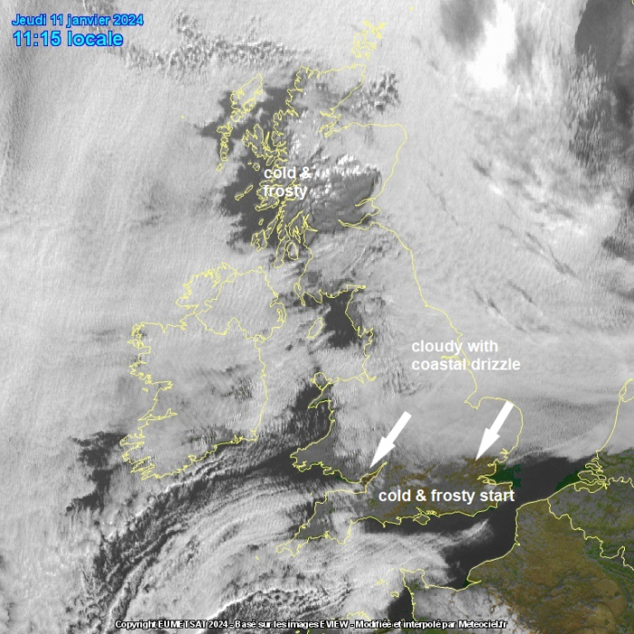
For now, cloud overnight has dictated who’s seen clear skies and a frost develop overnight and who’s remained frost free. Cloud has blanketed much of Scotland (away from the far west), northern England, Midlands and Wales, but across southern England skies remained cleared to allow temperatures to drop as low as -5C in Kent.
It will remain sunny for a time across southern England, but cloud further north will spread down through the day with most places away from the far west having a cloudy day with limited sunshine. Western and later central parts of Scotland and the far west of Wales and N. Ireland not doing too badly for sunshine, with clearer skies here. Temperatures a little up on what they have been in south today, reaching 4-6C, across N. Ireland and northern England 6-8C, Scotland 5-6C.
Cloudier tonight across southern, central and eastern areas of England – which will prevent a frost, but clearer skies across Scotland, N. Ireland, NW England and Wales will lead to frost and localised fog patches developing.
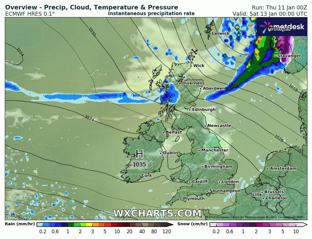
Generally dry with variable amounts of cloud and some sunny spells on Friday, best chance of sunshine in the north and west, though southern and eastern areas of England could stay dull with little in the way of sunshine. Thicker cloud and a band of rain moving down across northern Scotland in the evening. Temperatures reaching 6-8C, a bit below average for early January.
High pressure still clinging on close to the west on Saturday, so another mostly dry day with patchy cloud and some sunny spells, though some showers are possible across northern Scotland and turning increasingly windy here and breezy elsewhere across the north.
Sunday sees a change from the north, after bright morning in the south, a cold front in the north sweeps south, with thicker cloud and some showers along it, followed by increasingly cold northerly flow direct from the arctic, which will bring clearer conditions but also wintry showers falling increasingly as snow across northern Scotland. The colder and clearer arctic air reaching the south in the evening.
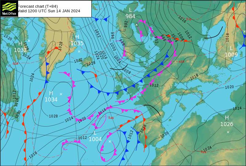
The cold airmass of arctic origin looks to linger through much of next week. Away from northern Scotland, eastern coasts and along Irish Sea coasts, which will see some sleet and snow showers, much of the UK will be dry and sunny but cold on Monday. However, an area of low pressure which develops near Iceland in the cold arctic flow, looks to drop southeast towards northern Britain Monday night, bringing with it an area of rain, sleet and snow from the northwest.
UKMO 'current laying snow' Monday to Thursday next week
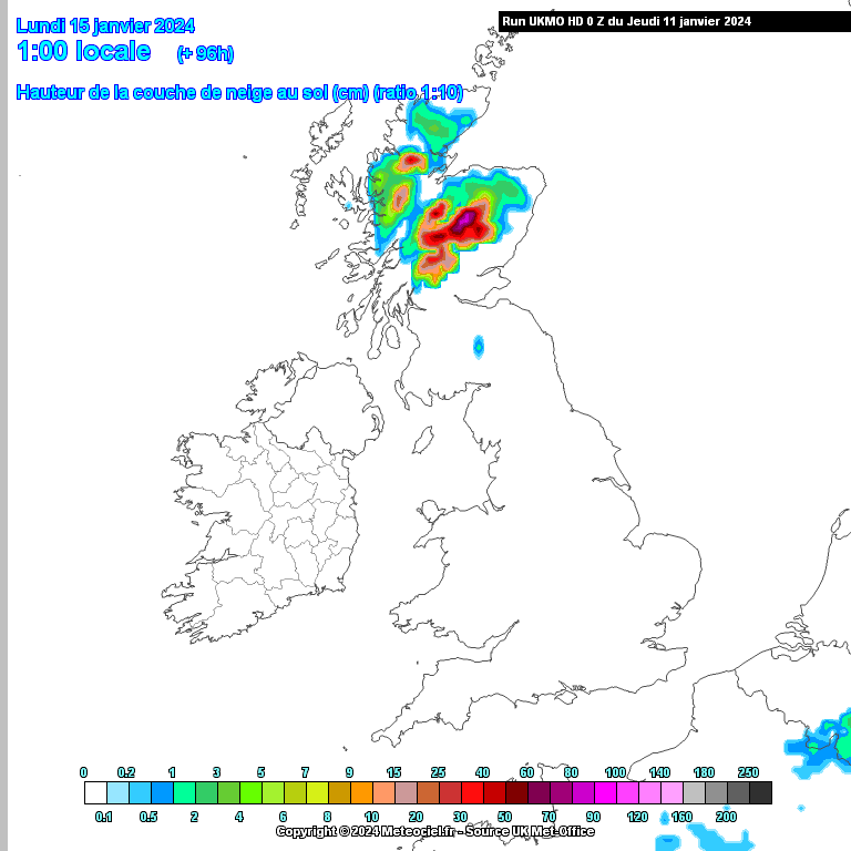
Snow looks to spread southeast across parts of Scotland Tuesday, perhaps in across the north of England and N. Ireland too, though could be rain or sleet in N. Ireland away from hills. Some uncertainty over the track of the low. Elsewhere across England and Wales it looks to remain dry, sunny and cold.
Then by Wednesday, there is potential for a low to move east from the Atlantic close to southern Britain, again, uncertainty over track of this low, could end up tracking over southern England or further south over northern France. But there could be a spell of snow on the northern flank of snow across southern areas, or it may miss to the south.
Otherwise, the rest of the week looks to remain sunny and cold, snow showers across the far north and around northern coasts, perhaps getting inland in a few spots. Perhaps another low moving east across the far south on Thursday bringing some snow, but low confidence on this.
You may see apocalyptic news headlines from the tabloid style news outlets, such as “14 days of snow as Scandinavian snow-beast hits Britain in worst Arctic onslaught in a decade” from GB News or “Latest weather maps show 750-mile snow bomb from Scotland to London in huge Polar blast” from the Daily Express. But in reality it’s turning colder for sure, with widespread overnight frosts, but it will be dry much of the time, though there will be a risk of snow at times, especially in the north, but perhaps in a few places in the south too later in the week.
Loading recent activity...