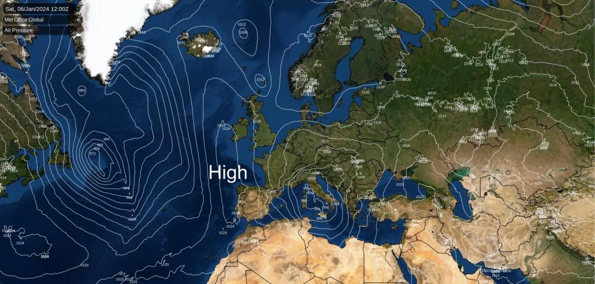
After the recent spell of wet weather with widespread flooding, the weather is set to turn much drier during the coming week, with high pressure taking over, which will help to alleviate the flooding situation.
It will be rather cold for a while, especially early next week, as we will pick up some cold continental air. This high-pressure area looks set to stick around until the 12th or 13th January. Eastern England may see a few showers on Sunday and Monday, which will turn increasingly wintry as cold air moves in from the north-east. These will be light and well scattered, so widespread lying snow looks unlikely.
At this time of year, sunshine amounts can be very variable under high pressure, as sometimes areas of cloud become trapped under the anticyclone and do not burn off in the daytime, resulting in anticyclonic gloom. This area of high pressure looks likely to be a predominantly "sunny" high until at least next Tuesday, 9 January, bringing most areas plenty of sunshine by day, with overnight frost and fog patches. The weather may turn cloudier from the 10th as some moist air from the North Atlantic moves into the high's circulation.
Towards mid-January, there is strong support for our high pressure to transfer to Greenland, allowing a very cold, northerly flow to spread southwards from the Arctic. Still, there is some uncertainty over whether this northerly will hit the British Isles directly or go out to the west or east of Britain. If we get a direct hit from the northerly, we may end up with a substantial cold and snowy spell. Still, some model runs have the northerly going into the North Sea, leaving Britain with further high pressure and generally dry weather, or out into the eastern North Atlantic, which would leave Britain more unsettled and relatively mild. Thus, there is potential for a significant wintry spell, but we probably won't know for sure if it will happen until near the end of the coming week.
Today, we are in a northerly airflow, but it is not pulling air in from very far north, so it will not be unusually cold for the time of year. Some showers will continue to affect Wales, predominantly north and west Wales, west Cornwall, northern Scotland, and the eastern side of England. It will be mostly cloudy in the east of England, but there will be plenty of sunshine elsewhere, and away from the aforementioned showery areas, it will be a dry day. Temperatures will be slightly below the seasonal average, reaching between 5 and 7C in most places.
Overnight, the cloudy weather in eastern England will spread to most other parts of England, except for the north-west, resulting in temperatures generally remaining above freezing. However, they will widely fall to between 1 and 3C. Elsewhere, under clear skies, temperatures will widely fall below freezing, resulting in a widespread frost. Some showers will continue to affect eastern England, mainly near North Sea coasts.
Sunday will see the cloud in England break up, resulting in most areas having at least some sunshine, and it will be a sunny day for most of Northern Ireland and western and southern Scotland. A light north-easterly will continue to bring some showers into eastern Britain, mainly near North Sea coasts, especially in north-east England. Over higher ground, these will turn to sleet and snow, but they will mostly be rain at low levels. Most places will miss the showers and have a dry day. Temperatures will generally be a degree down on today, reaching between 4 and 6C.
Monday and Tuesday will be the coldest days of next week for most of us, with maximum temperatures generally between 3 and 5C, and lower than that where we see overnight fog patches and the fog proves slow to clear during the daytime. Frost will be widespread at night. Most areas will be dry and sunny, except where fog lingers, but on Monday, some scattered light showers will continue to affect eastern England, this time mainly in the southeast, and these will produce sleet and snow to low levels. Most places will miss the showers, and by Tuesday, it looks set to be dry everywhere, with most places seeing plenty of sunshine. A strengthening easterly wind will set in in the south on Tuesday, making it feel colder out in the wind.
From Wednesday, cloudier weather is set to push in as moist air from the North Atlantic moves into the high's circulation, with an easterly or north-easterly wind picking up in all regions of the UK. However, southern England may hold onto predominantly sunny weather through Wednesday and possibly Thursday. The cloudier weather will be associated with milder air and a reduced chance of overnight frost. Still, temperatures are set to remain below the seasonal average by day, reaching between 4 and 6C in most areas during the latter part of the week.
Loading recent activity...