At present, there is still a lot of uncertainty over whether we are likely to see a white Christmas in some parts of the country, with the potential being higher the further north you are. Today's operational 00Z and 06Z runs from the GFS forecast model have the British Isles in cold north-westerly winds between 23 and 25 December, firing in wintry showers especially to northern and western areas.
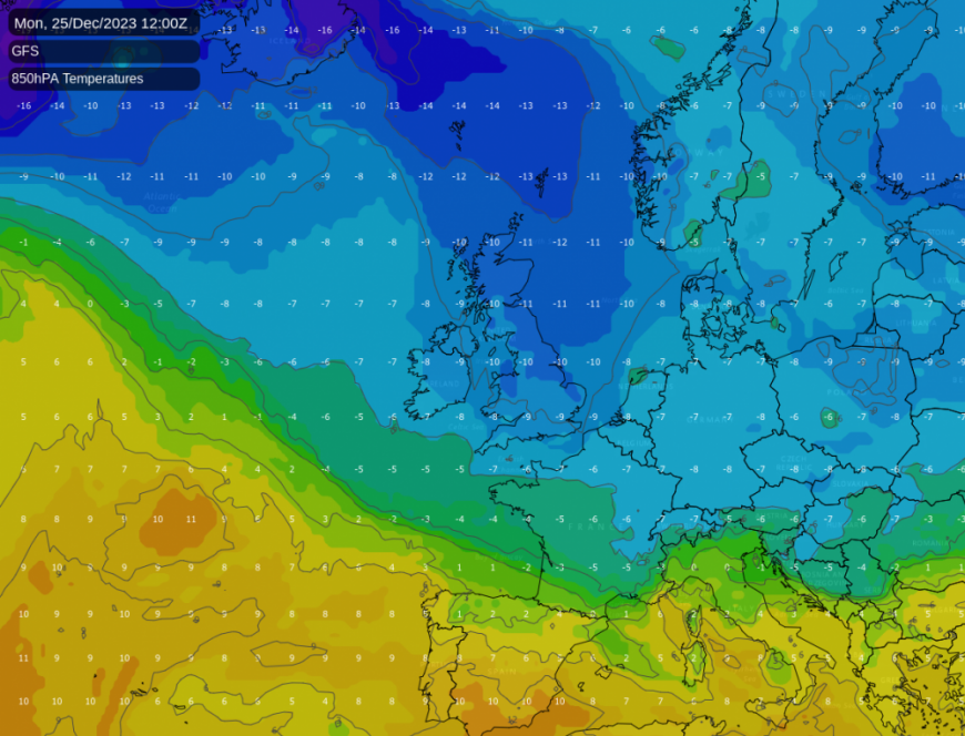
However, the ECMWF model, often more reliable at this time range, shows the cold north-westerlies failing to penetrate any further south than northern Scotland, and keeps the rest of the UK in mild air, while the Met Office model falls in between, giving a cold north-westerly around the 23rd but which may be shorter lived.
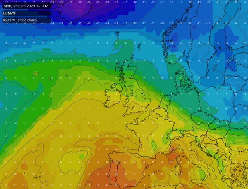
As the GFS has a long history of overdoing cold north-westerlies at this range, the odds favour mild air affecting much of the country by Christmas Day, but it remains too early at this stage to write off the chances of some regions seeing a white Christmas, and northern Scotland in particular currently looks to have a fair chance of seeing one.
What's more certain is that prior to Christmas we will see a transition away from the current high pressure regime and towards a somewhat more unsettled, and at times windy, westerly type, with mild weather dominating in the run up to Christmas, prior to the potential for cold north-westerlies to set in near Christmas.
At present, skies are generally clearer over the British Isles than what was modelled, so many areas, after a predominantly cloudy day yesterday, are waking up to a lot of sunshine. However, we still have plenty of cloud in southern England, and also in western Scotland and Northern Ireland, and the cloud in western Scotland is producing some rain, particularly in the north-west. Cloud will tend to increase from the west as the day progresses, but in parts of north-east England and the east Midlands it may remain sunny throughout the day. Cloudy skies with some light drizzle will develop over Cumbria and the rain will persist in north-west Scotland, but elsewhere it will remain dry. It will be windy in most parts of Northern Ireland, Scotland and northern England.
It will be a mild day everywhere with highs of between 10 and 12C for most, but parts of eastern Scotland and north-east England in the lee of high ground will be warmer than that due to the Föhn effect, especially in areas that retain plenty of sunshine. Highs of up to 15C are possible in north-east Scotland. With plenty of wind and a warm air mass covering the British Isles, a mild and frost free night will follow. In the areas of England that hold onto some clear spells, temperatures may fall to around 6C, but generally, lows of between 8 and 10C will be typical.
On Sunday, most of the country will have another mild and dry day, but rain will spread southward through the west of Scotland, spreading as far south as Cumbria and north Lancashire, and will also affect Western Northern Ireland. Many areas will see more cloud than today, but eastern England in particular has the potential to see further sunny spells.
Temperatures will generally be a degree or so down on today's, reaching between 9 and 11C in most areas but up to around 13C where we see a föhn effect kick in to the east and north-east of high ground. Again, much of Scotland, Northern Ireland and northern England will be windy, especially over and to the west of high ground.
As we head into next week, the weather will turn more unsettled as high pressure moves away to the south, allowing a changeable westerly type to take hold with frontal systems moving in at times from the North Atlantic. Through Monday and Tuesday, an area of cloud and light rain, most of the rain in the west, will spread southwards through the country, but with the potential for some heavier rain to affect the southern half of England on Tuesday before the band clears away. Behind the band there will be some sunshine and scattered showers, and on Tuesday much of Scotland, Northern Ireland and northern England look set to have a sunny day.
Cloudier weather will return from the west on Wednesday, with some rain at times, especially in the west, but the east of both Scotland and England will often be predominantly dry, with some sunshine coming through at times, although even the east will tend to be mainly cloudy. It also looks set to become windy for most late in the week, with potential for gales in exposed areas in the north. The big uncertainty sets in towards next weekend when it remains unclear whether we will stay in a mild, drizzly, cloudy regime or see cold north-westerlies spread in with sunshine and wintry showers, bringing the possibility of some areas seeing a white Christmas.
Check-in later today (Saturday) for the latest Christmas forecast and Santa Shaker update.
Loading recent activity...