It’s been relentlessly dull and wet for many over recent days, the rolling December average rainfall is well above average across many parts of the UK, though parts of the northwest, especially western Scotland – have been drier than average so far this month.
However, as we approach the weekend, the jet stream which has been close to the south of Britain will begin to move further north, taking the rain-bearing systems with it and allowing high pressure to build from the south. This shift north in the jet stream will herald a drier and more settled spell for England and Wales from tomorrow through to the beginning of next week. However, it will turn much wetter across western Scotland – which has been the driest part of the UK so far this month.
 Turning wet and windy across the far northwest this weekend, while England and Wales become drier under influence of high pressure
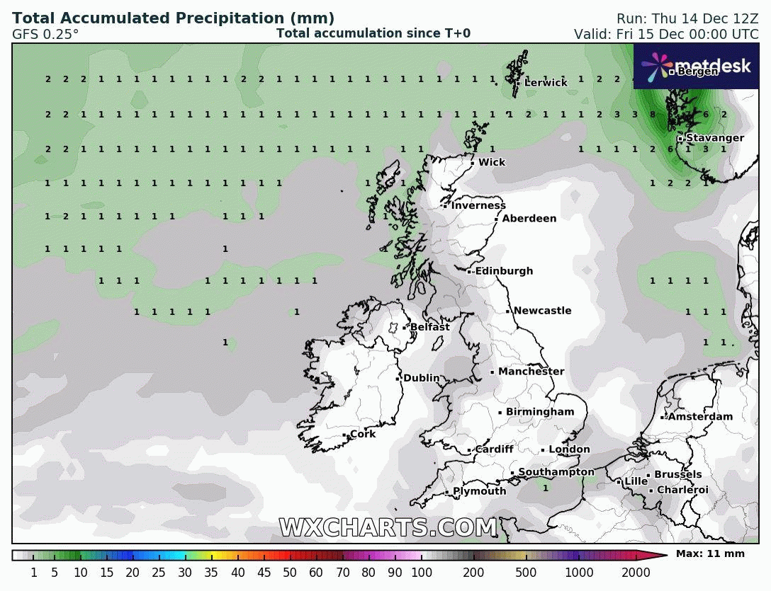
As the jet stream shifts north and high pressure builds north in its wake into the weekend, milder air will drawn up from quite a long way to the southwest, beyond the Azores. So it will turn milder by day and night, with temperatures widely in double figures. The foehn effect of the strong southwesterly flow across Scotland could bring highest temperatures, perhaps reaching the mid-teens, across eastern Scotland over the weekend. But the same strong southwesterly flow will also feed in large amounts of moisture from the sub-tropical North Atlantic – which will fall as persistent rain across the hills of western Scotland, aided by a slow-moving frontal boundary and orographic lift. While eastern Scotland in the rain shadow of mountains further west will be drier and perhaps very mild. The Met Office have issued a Yellow Rain Warning for western Scotland for 75-125 mm that could fall fairly widely, with 150-175 mm possible in a few places over higher ground. The warning in force 6pm Saturday and midnight Sunday night.
 Jet stream moves north this weekend, allowing high pressure to build north, before sinking south again through next week, eventually bringing unsettled, windy and cold air later in the week
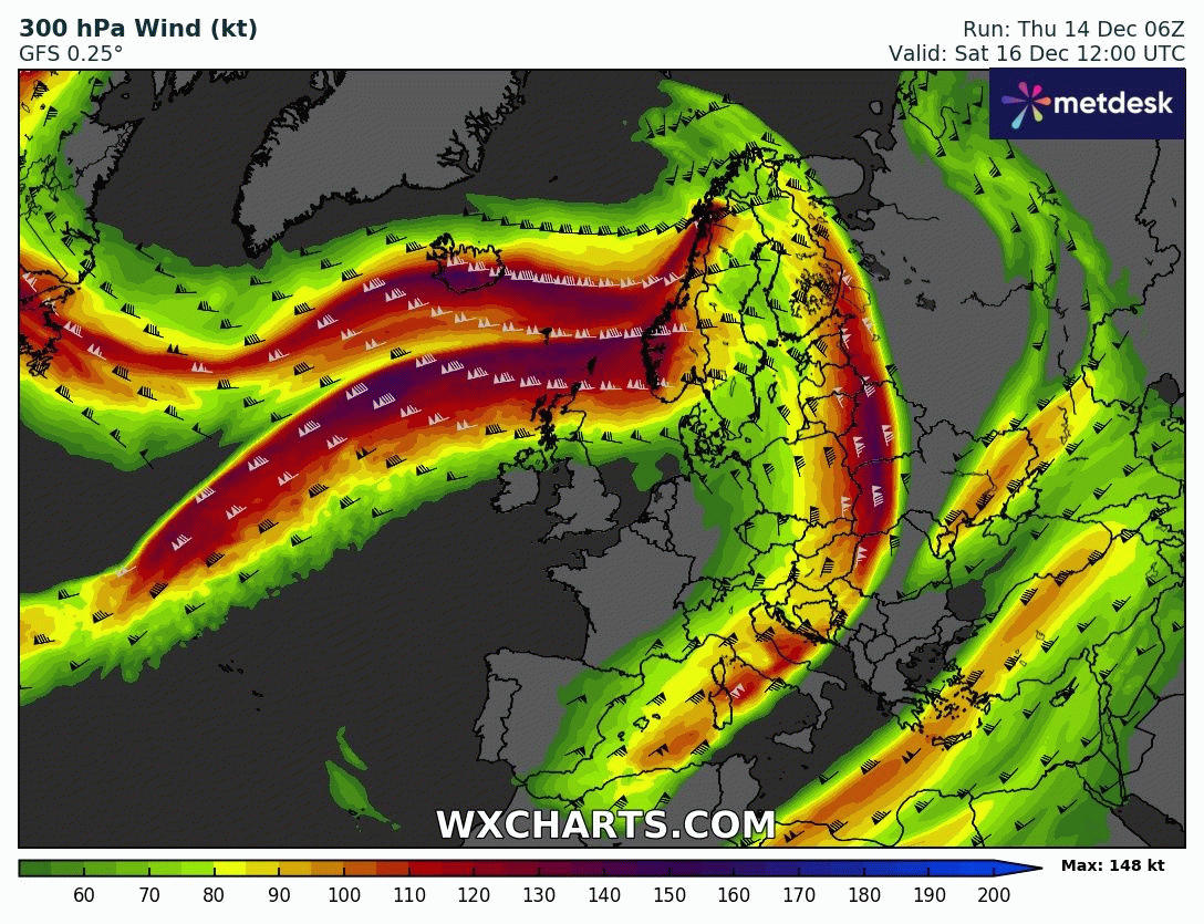
The jet stream then looks to shift back south again towards the middle of next week, this will bring rain-bearing frontal boundary affecting Scotland over the weekend southwards early next week, so probably one last dry day in the south on Monday, before a cold front arrives from the northwest Tuesday, bringing a band of rain through. Following this cold front an increasingly unsettled, windy and disturbed weather pattern looks to unfold for the rest of the week and weekend in the final run up to Christmas. This is thanks to a very strong 200mph+ jet stream forecast by models, which forecast to arc over the far North Atlantic, including the tip of southern Greenland, before plunging southeast to the British Isles and the rest of northern Europe.
So it looks to become very windy later next week and over the weekend before Christmas Day, with a risk of gales or even severe gales in places, also turning colder too from the northwest by the end of the week – with an increasing risk of snow across the north, especially over the hills. The timing of when the cold air arrives a little uncertain as is the threat of perhaps a deep depression affecting the UK, spawned by the strong jet stream, moving close to the UK later next week and the weekend of the 23rd/24th.
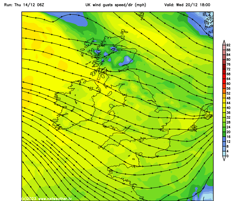
Potentially turning very windy later next week ...
 ... and turning colder.
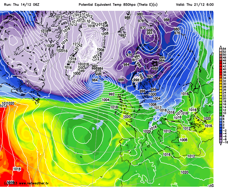
A few deep lows have popped up on recent GFS and ECMWF weather model runs passing close or over northern Britain, with severe gales indicated and even the threat of blizzards over higher ground in the north with the air wrapping into the depression cold enough in the north for snow to fall, especially over higher ground. 00z GFS and ECMWF runs this morning showed a deep low passing southeast over northern Scotland and on into the North Sea next Thursday, bringing gales to many places, severe gales in the west. Snow falling in the north, with blizzard conditions in the strong winds. 06z GFS control run had a very deep low crossing east across northern Scotland on Saturday 23rd. While the 12z run shows doesn’t show any particularly threatening depressions getting near the UK to cause disruptive and damaging winds, while delays bringing in the cold air, sub -5C at 850 hPa, until Saturday 23rd across most parts.
So a lot of uncertainty for later next week, as would be expected at 7 days plus away, but it does look to turn increasingly unsettled and windy Thursday 21st through to Christmas Eve- with potential for a deep low at some point in that period to bring disruptive gales or even severe gales and also, as cold polar air arrives in the mix eventually, the threat of disruptive snow in the north, especially higher ground. This is a period when a lot of people will be travelling before Christmas to spend time away for the Christmas period, visit relatives, etc. So worth making those reading aware there could be some disruptive weather in the run up to Christmas from the middle of next week. We’ll keep you updated nearer the time if disruptive weather looks likely.
As for snow on Christmas Day, still too far away to have any confidence where it could be white. For now, more likely to be green, possibly wet and windy for most, but can’t rule snow somewhere in the north, especially Scotland, closer to the cold air that won’t be far away to the north if not across northern areas.
Loading recent activity...