Storm Babet is with us to end the week, though trying to pin down a particular area of low pressure responsible for the bad weather it will bring is not so clear-cut.
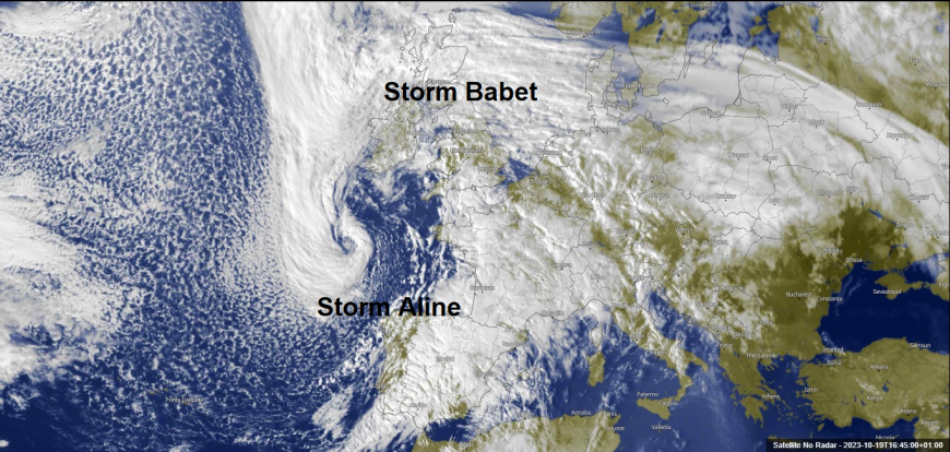
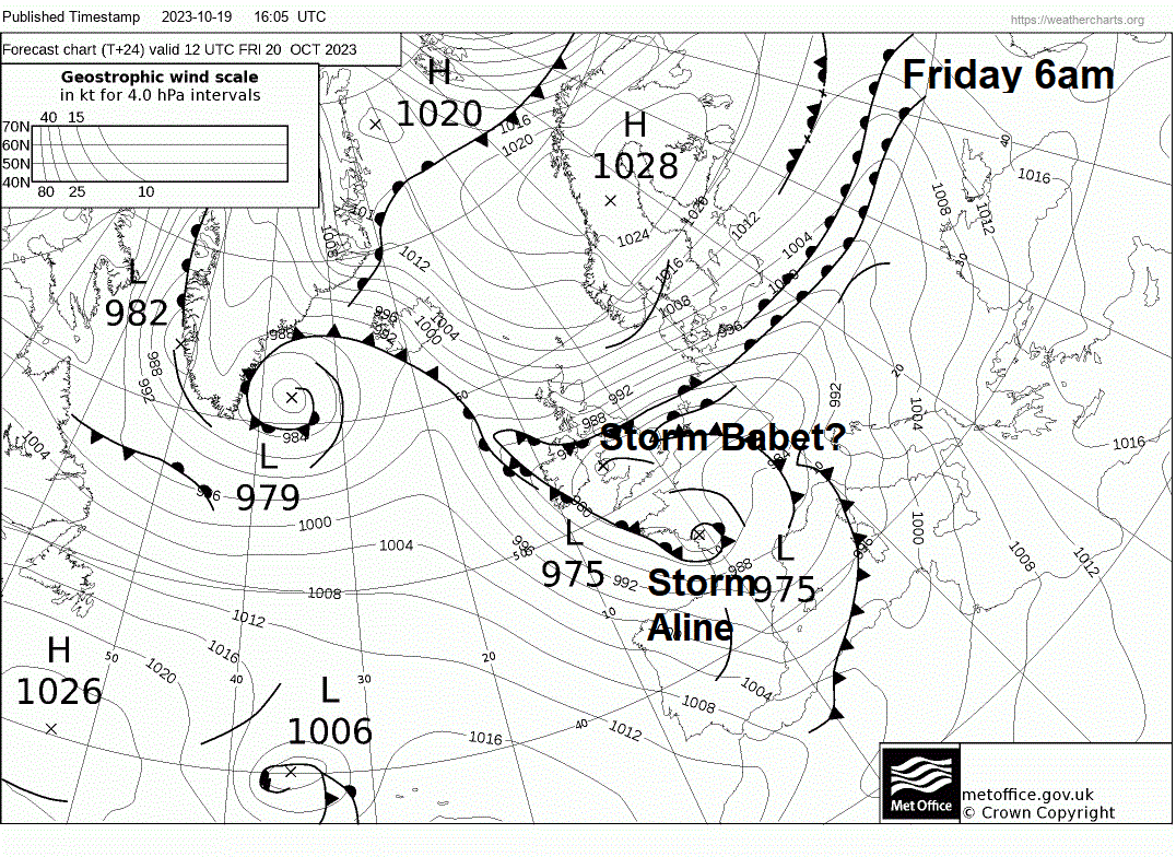
Yesterday, there was an area of low pressure which moved northeast from the Bay of Biscay before swinging north across England last night. However, the low is now just a wave moving north over Scotland on the northwest flank of the circulation of a larger low to the southwest of Ireland – which will deepen as it moves east into the Bay of Biscay tonight. This low to the southwest has been named by the Spanish Met Service as Storm Aline or, in Spanish, Borrasca Aline. This low looks to track east in across western France on Friday.
So Storm Babet doesn’t really have an identity as any particular area of low pressure anymore. Rather, the storm is the impacts of a much larger and complex low-pressure system affecting western Europe, with different secondary areas of low pressure, waves and troughs and associated fronts circulating around it that will bring the high-impact weather to parts of the UK, France and Spain to end this week.
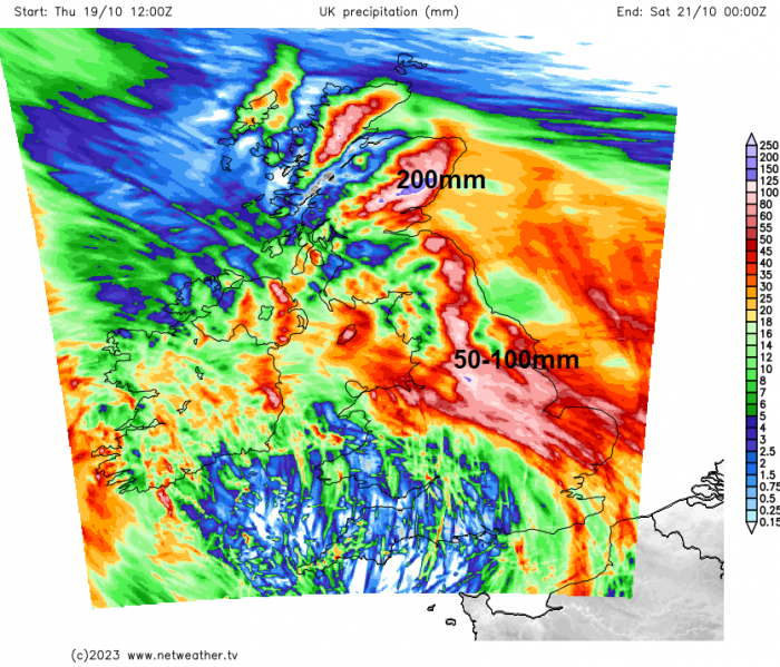
A frontal system that is moving north today, that accompanied an area of low pressure now becoming a wave, will stall across Scotland bringing high rainfall to eastern Scotland. The front creating lift will combine with the orographic lift of the Grampian mountains inland of the east coast of Scotland of moisture-laden southeast flow to create copious rainfall over windward slopes of the SE Grampians. 200-250mm possible in these slopes hence a red warning issued.
UKV rainfall accumulations until 00z Saturday
A plethora of Met Office warnings in force for Friday
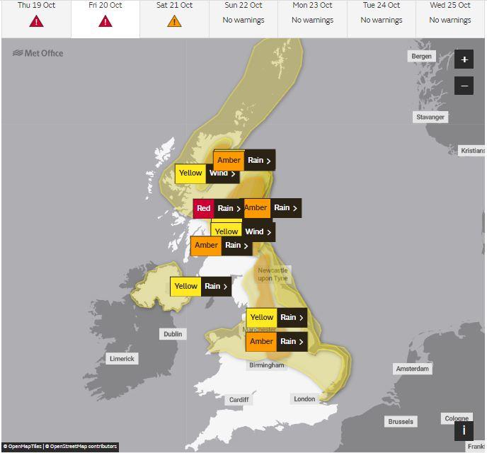
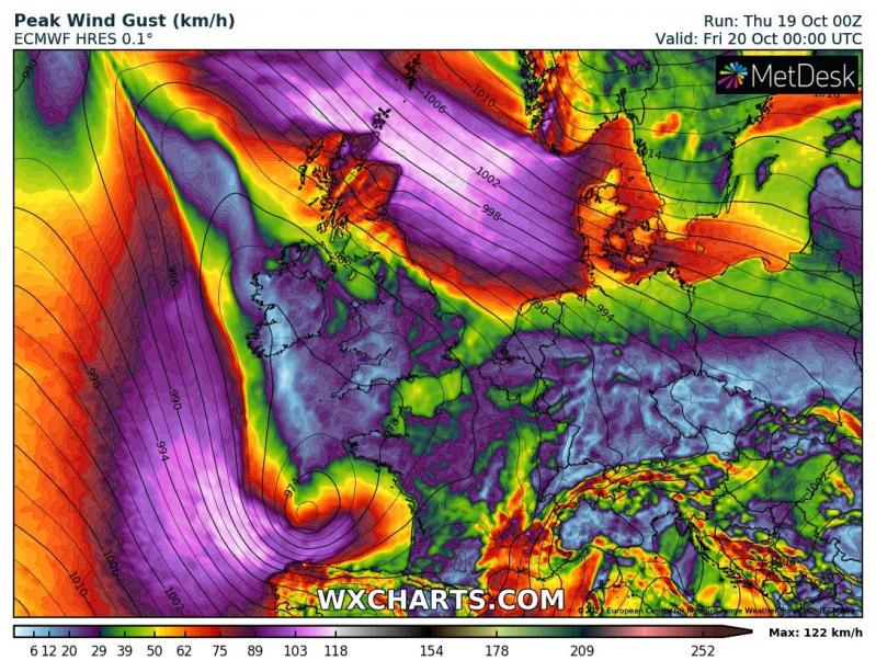
But, also, a strong pressure gradient is developing between the large low pressure system affecting western Europe and the strong high pressure centred over northern Norway. This gradient or tight isobars is generating strong easterly winds from NE Scotland and the Northern Isles across the North Sea to Denmark and beyond to the Baltic Sea. A wind gust of 77mph this afternoon at Inverbervie between Aberdeen and Dundee.
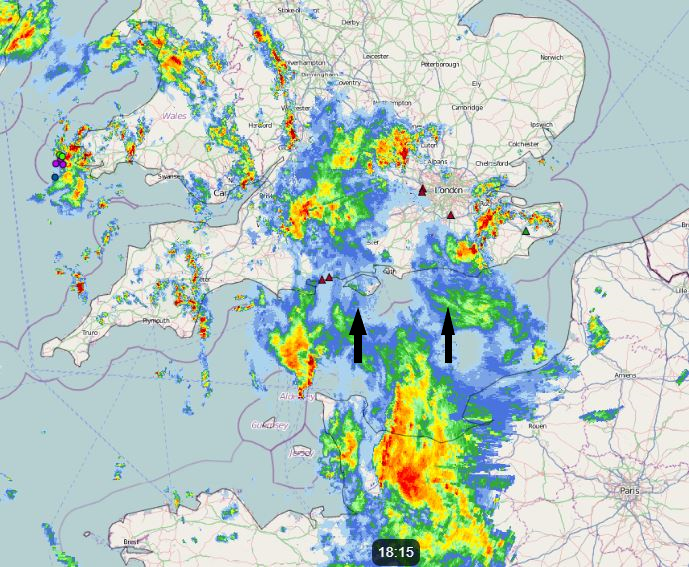
More rain will move up into southern England this evening in association with a new low forming over the far north of France which then looks to track north or northwest somewhere over eastern or central England tomorrow. The low looks to form in the left exit of a strong jet streak moving north over France. However, the development and track of this low has been causing all kinds of headaches for weather models and forecasters too. Heavy rain looks to develop ahead of this low and could bring large rainfall totals to parts of northern, central and eastern England over the next 24-36 hours, with the risk of flooding in places.
To the south of the UK over France and Spain, a deep area of low pressure moving east over the Bay of Biscay this evening will also bring severe weather impacts across parts of these two nations tonight and through Friday. The storm here has been named Aline.
For Spain, a Red warning is in force due to the risk of coastal flooding on the Atlantic coast of Coruña and the entire Cantabrian coast from Galicia to the Basque Country. The danger will be extreme throughout Friday, the 20th. The waves could exceed 8 meters in height. Also there is an Amber warning for the mountains inland from the coast, including the Picos de Europa for wind gusts up to 70mph. Also there are amber warnings for heavy rain in NE Spain, where 50-80mm may fall in the foothills of the Pyrenees. While there are amber warnings for wind covering the Balearic Islands – where gusts may reach 70nph. There are also yellow warnings for rain and flooding. Madrid was hit by flooding today, with the metro innundated with floodwaters this afternoon
For France, a Red warning for rain and flooding is in force for Friday for the Alpes-Maritime department in far SE of France bordering Italy – which includes Nice. Other inland departments of SE France from the Alps to Rhone Valley are under amber warnings for rain and flooding too. The French weather service Meteo France states and “Episode of heavy rains in the South-East, particularly marked in the Alpes-Maritimes, with significant floods forecast. Temporarily strong gusts of wind and strong waves on the coast of PACA and southern Corsica.”
The weather should calm down across western Europe over the weekend as the troublesome lows weaken – with winds easing and just sunny spells and showers around rather then the deluges and strong winds today and tomorrow. But more trouble looks like it’s brewing early next week, as another powerful jet streak arrives from the west over the North Atlantic and takes aim at western Europe, bringing in more low pressure systems from the west with more wind and rain.
Loading recent activity...