It’s been very mild and spring-like over the past week across England and Wales, the warmest place two days in a row was Pershore in Worcestershire, which reached a warm (for February) 17.2C on Friday and 15.9C yesterday. However, much of England and Wales has reached the mid-teens over past few days. The mean Central England Temperature (up to the 18th) is 6.5C, which is 2.7C above the 1960-1991 average. Northern Scotland has been quite chilly though over the last few days, with snow over higher ground. Low pressure moving across Iceland today is pulling milder air northeast across all of the UK though, with temperatures reaching the mid-teens again across the south.
It will continue rather mild across many parts into the start of next week, thanks to a brisk southwesterly flow drawing in Tropical maritime air. Temperatures again reaching the mid-teens widely across southern Britain and southern Ireland on Monday and Tuesday, low teens in the north.
But this early taste of spring could turn out to be a false dawn. Winds look to turn more northerly by mid-week, bringing temperatures back down to near or just below average on Thursday and Friday, with a return to frosty nights. There could be some wintry showers too in the north or northwesterly flow Thursday and Friday that follows rain clearing east on Wednesday, though any snow mostly confined to hills.
Well-above average temperatures early next week before turning colder by Thursday

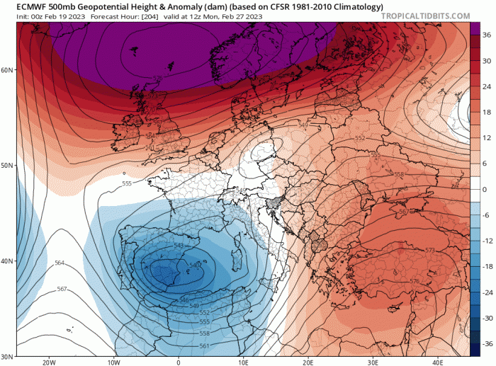
High pressure to the west of the UK later in the week then looks to move northeast to be centred close to northern Scotland by Sunday. So a northerly flow Friday and Saturday looks to turn more easterly on Sunday, pulling in cold air from continental northern Europe and continuing the chilly feel. The blocking high pressure system bringing in the chilly air from our east looks to become anomalously strong, perhaps record-breakingly so at 500 hPa, close to northern Britain in the last few days of February.
Last few days of February could see an anomalously strong ridge of high pressure close to the north, low pressure over SW Europe
So, it looks to be a chilly albeit more seasonal / close to average picture to see out the last 5 days of this month, with a risk of widespread frost and some wintry showers in places at first before it generally turns dry under the influence of an increasingly strong high pressure system close to the north.
But the anticyclonic and chillier spell to end the month and likely the first 5 days of March could be superseded by even colder and potentially wintry conditions as we head through early March. The reason for the temperatures falling even further, even with a risk of snow, rather than gradually warming up at the start of meteorological spring, can be attributed to the current Sudden Stratospheric Warming (SSW).
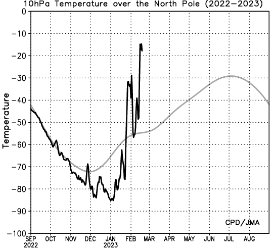
The warming high up in the atmosphere, at the top of the stratosphere, 40C over the space of days, has led to the reversal of zonal (westerly winds) normally present in winter at high polar latitudes. This has displaced a weakened stratospheric polar vortex towards northern Russia. The easterly winds at high latitudes look to slowly propagate down through the stratosphere to the troposphere (where our weather happens) over the next few weeks. This propagation of warming and easterly wind anomalies in the stratosphere downwards and coupling with the troposphere in early March is shown by the latest GFS northern annular mode (NAM) index below. The NAM is a measure of mass fluctuation between the pole and the mid-latitudes.
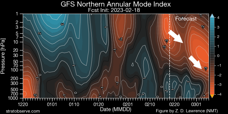
So in early March, we may see the stratosphere wind patterns coupled with the troposphere, with blocking high pressure building to the north and northwest of Britain, particularly around Greenland – while the displaced stratospheric polar vortex is mirrored in the troposphere to our northeast over northern Russia and Scandinavia. Such a pattern is repeatedly showing in recent GFS operational runs and GFS ensemble mean, and also ECMWF ensemble mean and clusters.
00z EPS mean showed upper trough to the northeast and ridge to the west for the 6th March - a cold arctic flow across the UK, northern and western Europe:
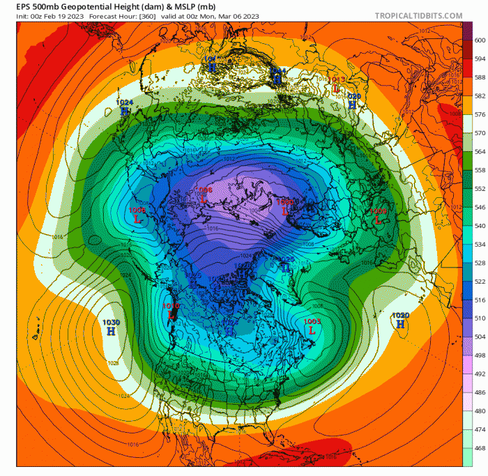
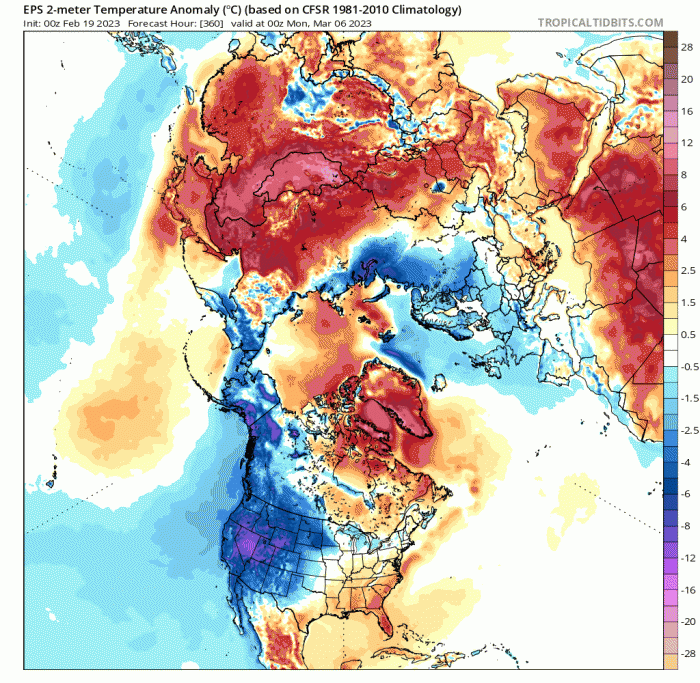
Should such an upper pattern occur, there is potential for very cold arctic air to be drawn south or southwest across Britain sometime in early March. However, this is very dependent on how far west the influence of the polar vortex over northern Russia extends and the positioning of any blocking high to the north, northwest or west in this period. A lot of water to flow under the bridge which may change things before then, not least the stratosphere pattern not coupling and reflected in the troposphere. But for now, it does look ominous for winter’s cold revenge in early March, with any hopes spurned by the recent early taste of spring and thoughts of winter perhaps being banished until next time perhaps premature.
It is nothing unusual to see winter bite back in spring after an early tease of spring-like weather in February, even in April, 2021 is a prime example, with snow falling April even in southern England. And this year, thanks to the recent Sudden Stratospheric Warming, there is an increased risk of cold and wintry weather in early March.
Loading recent activity...