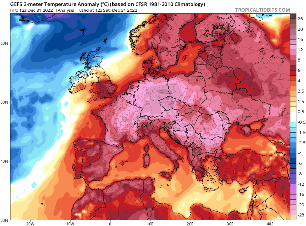
Large parts of Europe have experienced an unprecedentedly warm start to January, with at least eight European countries recording their warmest January day ever on New Year’s Day. Liechtenstein, the Czech Republic, Poland, the Netherlands, Belarus, Lithuania, Denmark and Latvia, saw maximum temperatures only normally seen in April.
On January 1, national monthly records were broken at Vaduz, the capital of Liechtenstein, which recorded a peak of 20C; the Czech town of Javornik reached 19.6C, Korbielow, a village in Poland, recorded a peak of 19C; Abed in Denmark recorded 12.6C; 16.9C Eindhoven in the Netherlands: Visokaye in Belarus reached 16.4C, with the national record broken by 4.5C ! Marijampole in Lithuania recorded 14.6C; Daugavpils in Latvia recorded 11.1C.
Bilbao in Spain, reached 25.1C, its hottest January day. Trois-Ville in southwest France, reached 24.9C, a record for the month for France and it was among more than 100 records set across the country Sunday. Ohlsbach, Germany, reached 19.4C - a January record for Germany.
Warsaw’s high of 19 C demolished the its previous January record by C, the January Polish high-temperature record was broken before sunrise in the town of Glucholazy – which reached 18.7C at 4 a.m., which is warmer than its average low temperature in midsummer.
Some of these cities in eastern Europe, especially the former Russian countries of Latvia, Lithuania, Belarus, would normally be covered in snow this time of year, but have been seeing temperatures more typically seen in April.
The unseasonably warm temperatures and lack of snowfall has also led to some European ski resorts having to close or resorting to artificial snow making to keep runs open, with the northern Alps and Pyrenees particularly struggling despite a good start to the season back in early December.
Ski slopes above 2,000 metres in the Alps have got near normal levels of snow, but lower down snow is in short supply or absent with bare mountainsides and slushy runs – particularly in the northern Alps and Pyrenees.
The shortage is particularly an issue around Switzerland’s Adelboden, which is set to host World Cup skiing on Saturday, and generally draws 25,000 fans for a single day of racing. The skiing event will likely be run on 100 per cent artificial snow this year. The Swiss resort of Splugen-Tambo, despite a base altitude of 1480m, said on Monday that it was closing "until further notice".
Unseasonably warm surface temperatures spreading across Europe during the frist two days of 2023
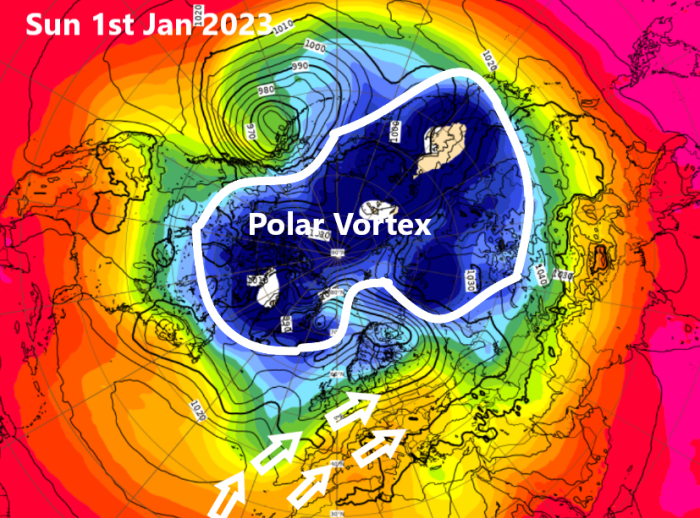
The reason for the unseasonably warm weather sweeping much of Europe has been the recent strengthening of the tropospheric polar vortex. The circulation of the polar vortex when it strengthens tends to tighten and shrink towards Greenland, pulling the polar front jet stream, which separates mild air and cold polar air, further north. This, combined with high pressure over southern Europe and the Mediterranean, has sucked up warm air as far south as western Africa and the Canary Islands over mainland Europe. Some locations to the lee of the Pyrenees have reached as high as 23C, thanks to the foehn effect.
England and Wales have been mild too since a cold spell in early December, which ended a week before Christmas, though not record-breaking warmth as on the continent – due to cloudier skies, wind and rain off the Atlantic. Scotland has often remained cold, with frosts and snow in the Highlands, though even here will turn milder this week.
It looks to remain mild but unsettled across much of the UK for the next 10 days at least, as the tropospheric polar vortex looks to remain strong to the northwest of the UK, driving a strong jet stream towards the UK and a conveyor of low pressure systems bringing wind and rain at times.
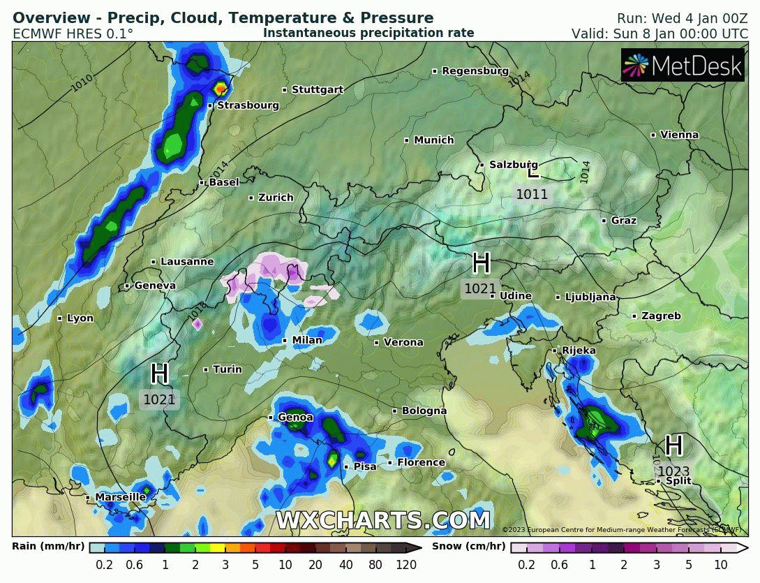
But there might be some good news for the European Ski industry from the weekend onwards, at least for the Alps anyway, with recent high pressure conditions being replaced lowering pressure from the northwest, with rain-bearing Atlantic frontal systems penetrating east across France and over southern Germany, Switzerland, northern Italy and Austria – bringing snow to higher ground, though likely rain at lower elevations. But there are signs that cold but drier conditions may spread from the northeast after mid-month.
For the UK, polar maritime incursions at times in the wake of low pressure systems moving east may bring some snow over the Scottish mountains from the weekend and through next week. But most of the UK it’s looking green, no sign of it becoming cold enough for snow away from Scottish mountains for the foreseeable future. Not until the polar vortex to the northwest relaxes its grip to allow blocking high pressure to build and bring in colder air.
The models are forecasting the Madden Julian Oscillation (MJO) to move through phase 8 (western Pacific). The MJO wave of enhanced tropical convection when it passes over the western Pacific tends to promote amplification of the upper flow in the mid-Latitudes of the north Pacific which eventually works downstream over North America and the North Atlantic and can lead to blocking patterns that lead to colder weather in winter. But it remains to be seen if the MJO wave will be enough to disrupt the influence of the strengthening polar vortex which will try and keep the flow strong and zonal (west to east) – which drives low pressure towards the UK and floods mild sub-tropical north Atlantic air across Europe and the UK.
Loading recent activity...