The 24th May 2016 will go down as one of WeatherHolidays most successful ever storm chases with the most Tornadoes seen in 1 day to date, with 17 different Tornadoes witnessed over 3 hours with 2 Sets of Triplets and three sets of Twin Tornadoes.
This was Day 4 of 6 in a very favourable period of weather for Tornadoes across the Central and Southern Plains. The Set Up was pretty much perfect, with a Large Upper Trough stuck over or just to the east of the Rockies with a Blocking High over the Missouri and Ohio Valleys stopping its progress eastwards. The previous three days had all seen Tornadoes occurring across Kansas, Oklahoma and Texas from a similar set-up. Once again, abundant moisture was in place. An Outflow Boundary was draped just north of the Interstate 40 corridor from the past evening's Storms and Tornadoes which had occurred across the Texas Panhandle and North West Oklahoma.
We started the Day in Childress at the Days Inn after a late night chasing and documenting the Turkey (Tx) Wedge Tornado the night before just west of Childress, and my target area had not changed much from the night before. The main thing was to track the Outflow Boundary. A quick look at Vis Sat showed it up just North of Woodward, lifting slightly Northwards as the sun started to bake the morning air.
The SPC went with an Enhanced Risk of Storms and placed a 10% Tornado Box from Woodward to Enid and into adjacent Southern Kansas. I got the guests ready with breakfast at 9am and on the road at 11am heading northwards and a quick lunch stop at Shattuck, which was just SW of Woodward. Some visited the Windmill Museum whilst others ate their lunch. Checking Data, the Outflow Boundary was still moving North. It was now progressing into Southern Kansas from the Liberal to Medicine Lodge area, so I knew we had to keep heading North to stay up with the rapidly growing convection. We continued into Kansas and headed onto Greensburg, where we topped off the cars with full tanks of Fuel. By now, the first storm of the day had erupted further South West near Liberal and had already gone Tornado Warned. The temptation to blast west towards this was high on everyone's agenda, but our part of the Outflow Boundary was exploding skywards, and I knew it would not be long before we had a Supercell erupt in front of our eyes as well, which was in an even better environment with much better-backed winds further where we were.
Within 20 minutes, we had a storm, and within 40 minutes, a full-blown Supercell was in front of us as we approached the town of Minneola from the South on the road North towards Dodge City. As we neared the four-way main junction, the Tornado Sirens started to blare, and our storm instantly was Tornado Warned. We headed out of the small Kansas Town, and out to our Left to our West and North West showed us a beautiful Classic Supercell Structure with Wall Cloud starting to form. We went another 7 miles north, and I then stopped us on a small dirt farm track, so we were level with the Wall Cloud with the Precip falling to our North and lightning flashing away; part of the precip core was hitting us at this time, and hail started to fall on us, mainly small thankfully, the wall cloud was beginning to rotate around 5 miles to our west, and I knew it would not be long before we had our first Tornado (It just had that look about it) and what I also noticed was an occlusion and another wall cloud forming from a separate Mesocyclone within the same storm. This usually denotes a Supercell has a chance of Multiple Tornadoes on the same storm.
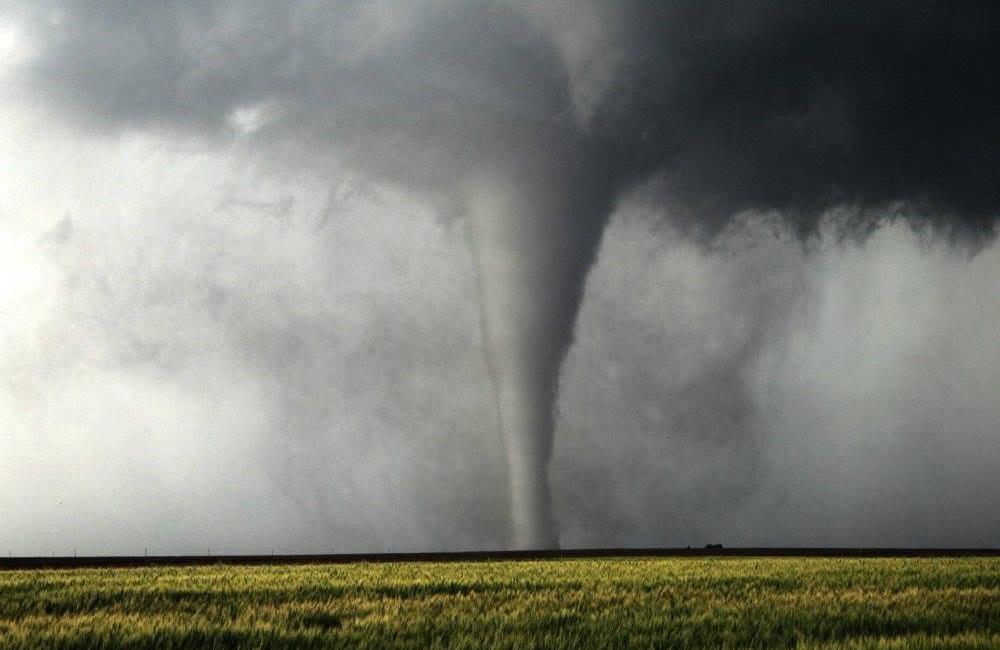
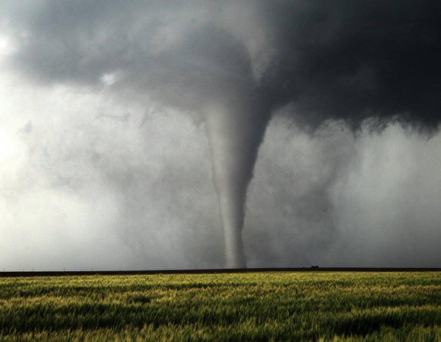
At 435pm, we had our first touchdown, a beautiful, almost Wizard of Oz Tornado dancing in the open fields about 4 miles to our North West, this grew into a fat stovepipe before the RFD cut off the feed of warm air and the Tornado dissipated after being on the ground for around 12 minutes.
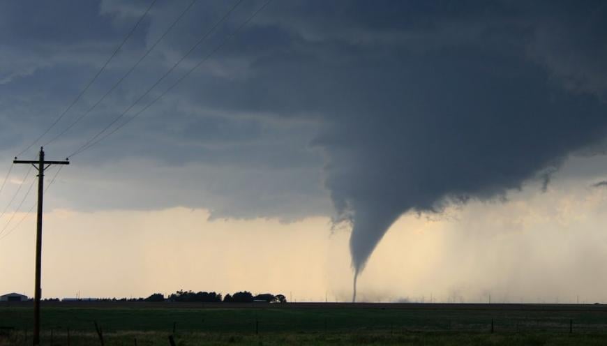 Tornado Number 1 touches down at 435pm South of Dodge City (Ks)
It wasn't long, though, before Tornado number 2 touched down, and this one was bigger, as this was now about 5 miles to our North West and seemingly moving North. I gathered everyone into the cars, and we sped off down a network of dirt roads, heading west a few miles, then north a few miles, then west again, always keeping up with the Tornado on the ground. We stopped briefly to snap a few more pictures, but it was apparent the next Tornado was going to form from another Occlusion.
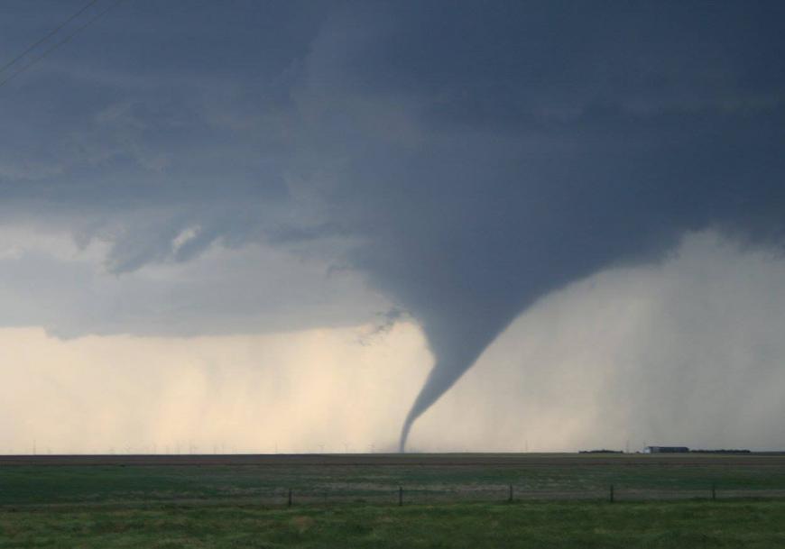 Wizard of Oz Type Tornado Number 2 South of Dodge City (Ks)
We set off again, west and then north again, on dirt roads which were now getting more challenging to keep driving on as the precip core had impacted these areas by now, and the mud was becoming hard to keep the cars straight on, some tremendous sideways driving from our drivers.
By now, we had one of the biggest Tornadoes of the day touch down to our west. I knew we had a tarmac road coming up in about 2 miles, so we kept on driving with the Stovepipe Tornado churning away to our west and another smaller rope Tornado touching down on the dirt road in front of us.
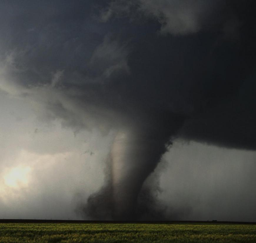 Large EF3 Tornado Churns away 2 miles to our West - South of (Dodge City Ks)
One or two of the guests were starting to get quite nervous at this point, but the staff did a great job of letting them know the situation was very much in control, with both Tornadoes moving away from where we were if we had become stuck in the mud so to speak.
 Tall Stovepipe Tornado in Kansas
Finally, the Tarmac East to West road appeared, and I stopped us just off that road on a farm road with a stunning wheat field in front of us waving in the southeast warm breeze, a full-blown EF3 Tornado around 2 miles to our west, then North West churning away silently thankfully not hitting anything. Looking North on our dirt road, another Tornado was touching down with another to its North East, we had triplets, but we needed a wide-angle lens to get all three into frame.
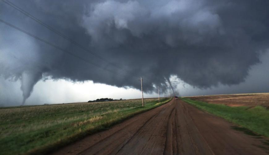 Twin Tornadoes on the Ground - The 3rd would come from the Wall Cloud furthest right.
This storm was simply incredible, and the road Network of South West Kansas was also unbeatable, with 50 mile views in every direction and fields dotted with farms as far as the eye could see………….but Dodge City was now only 10 miles to the North. These Tornadoes did not seem to want to give up anytime soon, and the storm was on a collision course to the North towards Dodge City, which is quite a large Town.
After everyone had pictures taken of the Tornadoes, we relocated once again - Eastbound on Tarmac and then North on Highway 283, so we could get North of Dodge City as we did not want to be caught in an Urban area with Tornadoes gunning down on us.
We documented another Wedge Tornado, which barely missed Dodge to its west and thankfully lifted as the Supercell rolled over the Large Town.
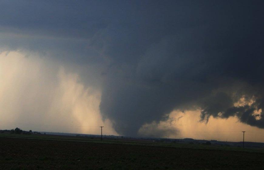 Wedge Tornado about to move into Dodge City (Far Right of Picture) Tornado Number 12
We continued towards Jetmore and once again out into the countryside. Another 2 Tornadoes were witnessed as we were driving, and then another, which pretty much gave the cars a spin cycle as the clear slot went above our heads.
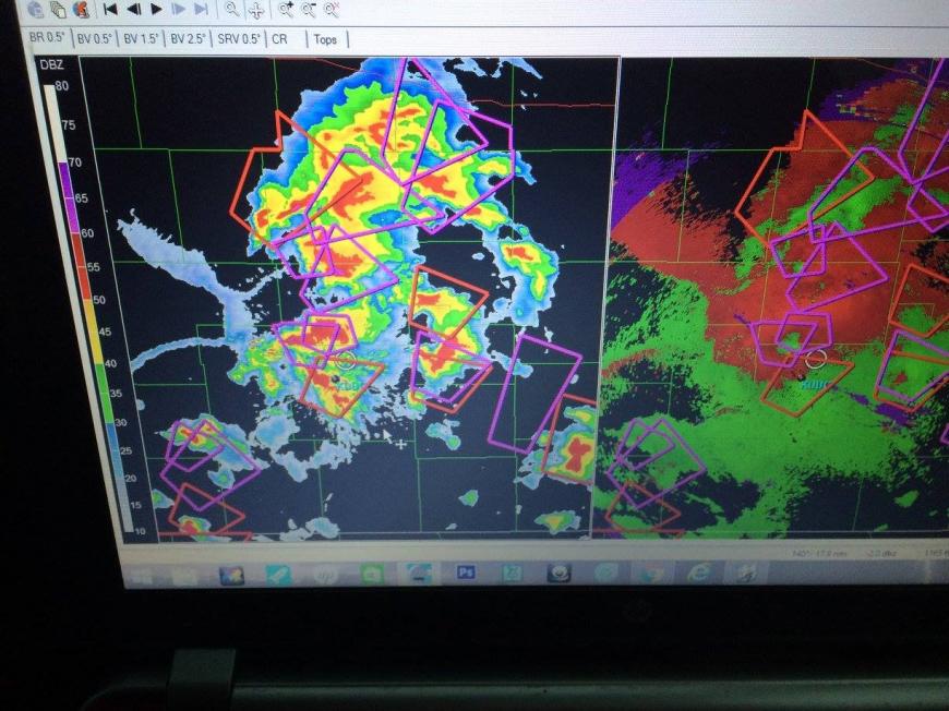 Our location is the White Circle - Time to pick a safe path through these Supercells.
With 17 Tornado Warned Storms around us at this time and light fading, I called the chase off. We picked our way back through various Tornadic Storms to get a fully deserved Steak Meal in Dodge City at one of the few places that still had power and marvelled at the incredible Mammatus display, which was being lit up by the setting sun.
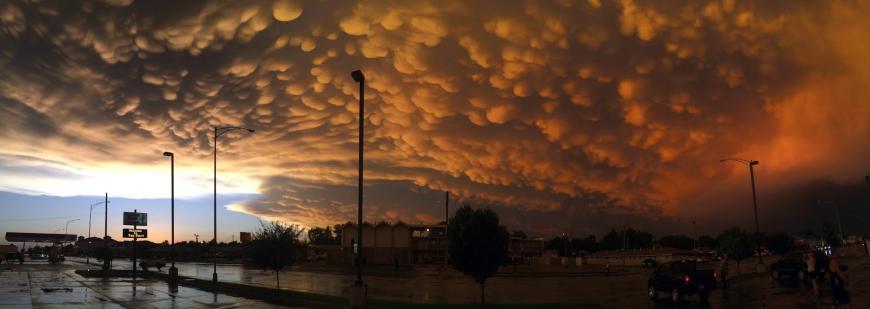 End of the Day In Dodge City after the Storms were clearing away.
A genuinely remarkable Cyclic Supercell which had travelled pretty much North along an Outflow Boundary and dropped a family of Tornadoes of all different shapes and sizes ranging from EF0 to EF3.
Loading recent activity...