Snow has fallen in number of areas so far this weekend and these areas will expand during Sunday. The last 24 hours saw frequent sleet and snow showers affect northern and western Scotland, NW England south of Cumbria, west Wales, Devon and Cornwall – giving a couple to several centimetres in places and leading to some treacherous conditions with some travel disruption. Manchester Airport’s runways were closed during Saturday morning, delaying flights, with some passengers left stranded on planes for several hours. While there were some issues on roads in Devon from snow.
Arctic air has been entrenched across the U.K. since earlier in the week, a blocking area of high pressure will persist over southern Greenland and Iceland over the next few days, with an upper trough to the southeast covering much of northern Europe, with the UK on the western side of the upper trough. Although the surface synoptic flow is rather slack, with light or calm winds leading to some freezing fog patches, some minor troughs with areas of enhanced vorticity moving south around the upper low will bring areas of lift leading some snow in places over the next 24 hours.
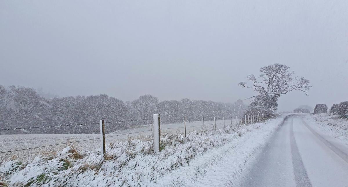
Parts of Britain are seeing snow from the word go to start Sunday. Sleet and snow showers continue to affect coastal areas of northern and eastern Scotland, getting inland across SE Scotland, also the northern coasts of Northern Island along with the north coasts of Devon and Cornwall.
Further east though, a less straightforward picture for the weather models to handle is evolving. Upper trough moving down from the north and associated enhanced vorticity is bringing some outbreaks of light to moderate snow across parts of the West Country and into the south Midlands. At least a couple of centimetres likely here this morning, locally more, before this area of snow generally peters out to scattered flurries – according to most model output.
Snow across parts of Gloucestershire, Wiltshire, Dorset, Hampshire and Dorset should ease this afternoon.

As this upper trough and associated area of vorticity sinks over the English Channel, it will looks to interact with ongoing convection over the Channel, where cold air aloft over SSTs of 12C is creating steep lapse rares, to form an area of low pressure. This low looks to drift NE in across Sussex and Kent this evening, lobes of vorticity and moisture wrapping around the low off the Channel and North Sea looking to bring increasing outbreaks of moderate and locally heavy snow for a time across parts of SE England and East Anglia this evening and overnight, before the snow peters out as the low fills Monday morning. Potential for 5-10cm locally across parts of SE England – particularly, I think, inland parts of East Sussex, Kent, Essex, East London and Hertfordshire.
Upper low moving south with vorticity around it bringing snow to southern areas of England today.


Elsewhere, another upper trough dropping SW from the Norwegian Sea past the western Isles looks allow an area of low pressure to form over western Scotland this evening before moving SW out into the Atlantic. This is likely to bring enhanced and more frequent shower activity across northern and western Scotland and down across western N. Ireland. Showers likely mostly rain / sleet and near coasts, but snow inland and over hills. Could bring several centimetres to western Highlands
Met Office Yellow Warnings for snow, ice and freezing for parts of the UK on Sunday


Another hazard today for southern, central and eastern areas of England are areas of freezing fog that formed overnight lingering today, thanks to calm conditions. Where the fog persists, some low visibility and temperatures may struggle to get above freezing.
Monday starting off rather cloudy, misty and, in places, some freezing fog across central, southern and eastern England. Some patchy snow may still linger for a time in the morning across eastern Home Counties and East Anglia before petering out. Otherwise may stay grey for some with further snow flurries in places. Brighter for west Wales, northern England and Scotland, but with some coastal wintry showers possible.
A lot of uncertainty by Tuesday. GFS over the last few operational runs keen to bring in a band of rain across southern, turning to snow inland. Although this has some support from its ensembles, other models don’t get the precipitation as far northeast, EC and UKMO in as far as far SW of England before retreating. Otherwise, what looks more certain, is an area of low pressure forming just east of the Northern Isles dropping south down the North Sea allowing a cold northerly to develop, with snow showers blowing in across northern and eastern Scotland and running down North Sea coasts as far as the Humber later on Tuesday and through Wednesday. Met Office have a yellow warning in place for mainland far north and northeast and Northern Isles.
.jpg?w=700)
Elsewhere, a drier picture but cloudy in the south Tuesday, with uncertainty over rain and snow moving into the south or not, but most likely only reaching SW England before turning drier, sunnier and colder from the north across England and Wales on Wednesday.
Loading recent activity...