A look at how three tropical storms have helped or will help shape our weather fortunes this month, even if their remnants are not directly coming over the UK.
It is fairly common during September for ex-hurricanes to affect the UK weather both directly and indirectly as they swing NE across the North Atlantic. On average, an ex-hurricane will take a direct aim at the UK once every few years, though even if these storms don’t take aim at the UK and instead head towards Iceland, they can drag large amounts of warmth and moisture across the UK to bring a late taste of summer.
Most tropical storms or hurricanes track westwards towards the Caribbean, Gulf of Mexico and North America and usually either lose strength when they make landfall or travel over cooler waters of the North Atlantic. Occasionally their track takes them far enough north over the Atlantic that they interact with the jet stream, which can then transport the remnants of a hurricane towards north-west Europe.
Technically a true hurricane cannot make it as far as the UK, as the waters that surround NW Europe are far too cool to sustain them. Instead, the ex-tropical remnants of such systems can occasionally develop into powerful extra-tropical depressions, thanks to warm and moist air from the tropics still wrapped in them interacting with the contrasting colder air north of the jet stream which tends to scoop up these ex-tropical storms and sends them towards Iceland or the UK.
Even hurricanes that stay the other side of the Atlantic can have far reaching impacts on the upper flow downstream over north Atlantic to the extent that they can create large atmospheric waves that can influence trough and ridge patterns over Europe. Any high pressure ridges that form in these waves can be more intense than usual due to the large amounts of heat transferred upwards into the atmosphere creating blocking high pressure. This can lead to intense heatwaves over SW Europe for example, as was seen in SW France earlier this month ahead of the remnants of ex-Hurricane Danielle, which loitering off Iberia pumped very hot air north from NW Africa.
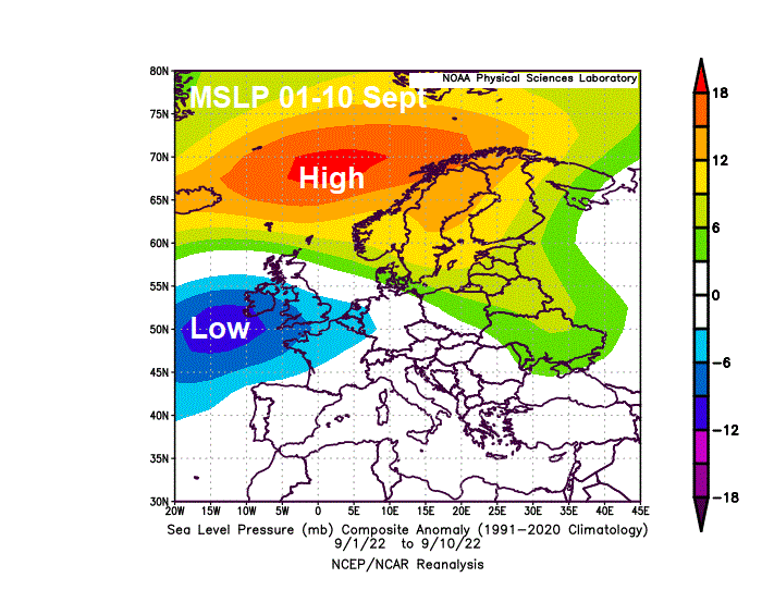
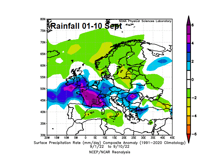
Although the Atlantic hurricane season remained unusually quiet into the begining of September, the first half of the month was unsettled, particularly the first 10 days, with slow-moving low pressure parked close to the west – bringing some much needed rain to the UK and much of western Europe, easing drought conditions that developed during an exceptionally dry and hot summer. But it was also quite warm, with winds from the south or southwest.
After the 10th, fronts bringing rain moved in off the Atlantic, while the remnants of Hurricane Danielle arrived to the southwest close to Iberia. Initially this pumped some hot air across Spain and western France, leading to the September maximum temperature record being broken in France, with 40.7C recorded in SW France. With very warm air also reaching the south for time, culminating in 27C in London on the 12th. But this was followed by rain across the south on the 13th and 14th, as the frontal system from the Atlantic merged with warmth and moisture pumped north from ex-Danielle.
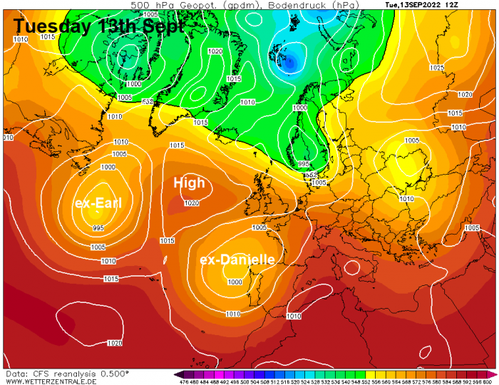
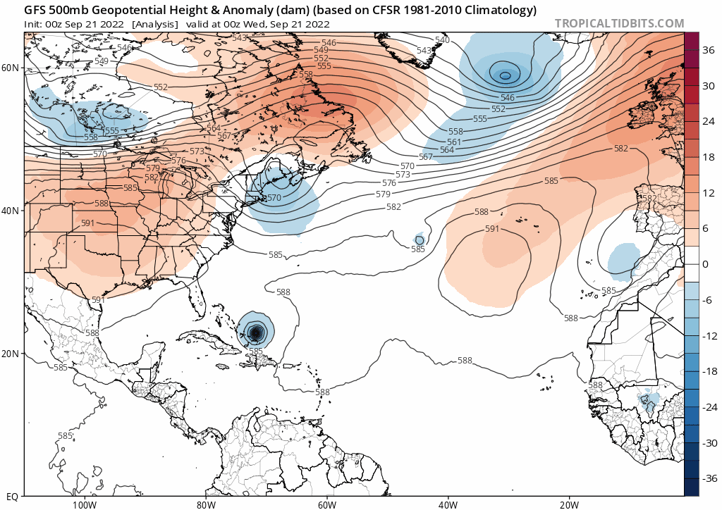
However, from the 15th, pressure began to rise from the west as an anticyclone built over the mid-North Atlantic. This strengthening area of high pressure likely helped by Hurricane Earl upstream amplifying the flow downstream over the mid-North Atlantic.
High pressure close to the west during the second half of last week brought drier more settled conditions for many. High pressure then shifted east over NW Europe and has dominated the UK’s weather since the weekend. However, the high has also pumped chilly arctic air south into much of mainland Europe, leading to below average temperatures for late September, especially at night. With frost in rural areas.
The UK has also seen some cool days and chilly nights since late last week. But the area of high pressure centred over southwest Britain to start the week has drifted southeast into Europe. This allowing warmer tropical maritime air to flood Britain yesterday and today ahead of a cold front to pushing southeast, bringing a spell of rain in the north before reaching the south tonight, the rain lingering across the far southeast for a time on Friday before clearing.
Yesterday I talked about how Hurricane Fiona steaming north towards Atlantic Canada over the weekend will again amplify high pressure north downstream over the North Atlantic. The amplification will be stronger than it was from Hurricane Earl earlier in September, so the ridge of high pressure over the North Atlantic will be stronger, but also the downstream trough into Europe will be deeper and more amplified.
Hurricane Fiona heading towards Atlantic Canada will help amplify North Atlantic high and Europe trough downstream, bringing cool polar air to Europe
This will mean a strong plunge of polar air across the UK, Ireland and northern Europe early next week, following a cold front pushing south Sunday night and Monday morning, bringing a band of squally rain, with a cool and showery polar flow from the north or northwest continuing through much of the week, thanks to deep upper trough and low pressure close to the east and high pressure to the west.
Cold front pushes south on Monday
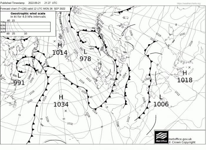
Cold polar plunges southeast into Europe through next week, bringing a cool end to September
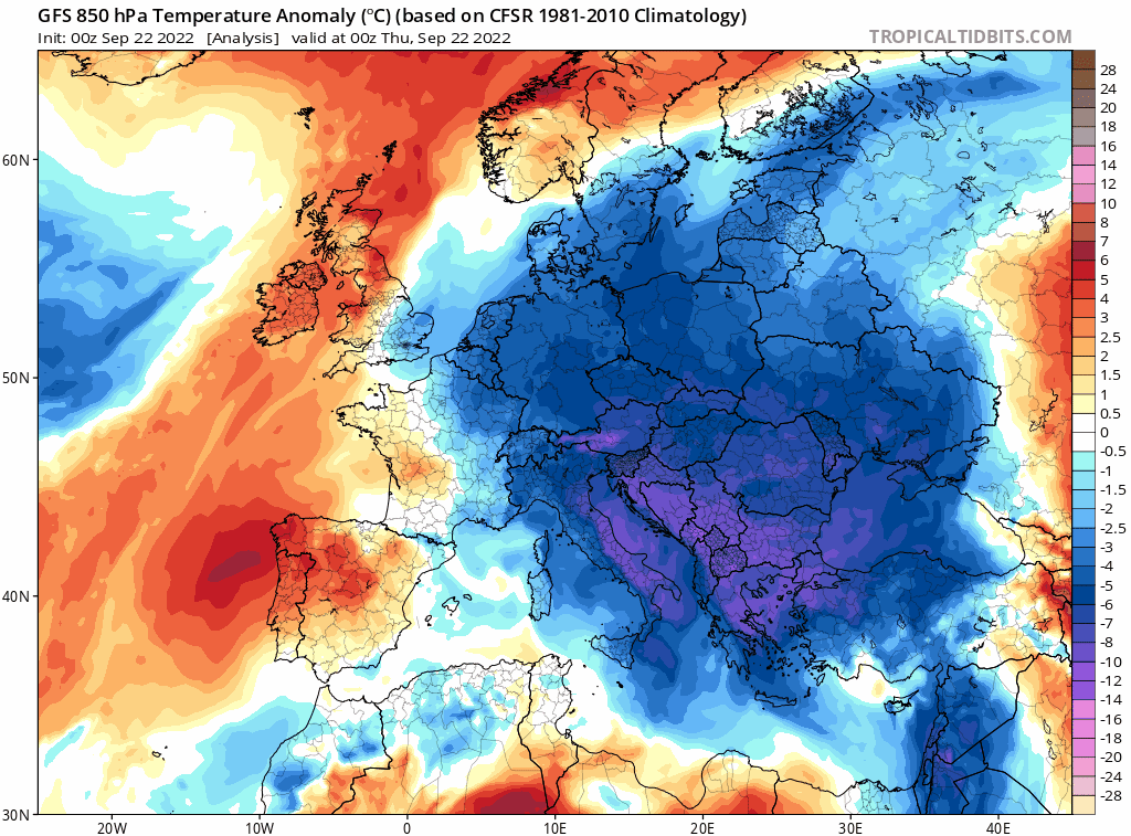
So a cool, unsettled and autumnal end to the month on the cards. Temperatures are currently generally between 1-2C above the 1991-2020 average, thanks to a warm first half to September, but the upcoming cooler last 5-6 days of September may reduce the above average temperature anomaly, perhaps close to average by the end of the month.
Loading recent activity...