Update on Storm Franklin for Sunday night and Monday morning after heavy rain and wild wind gusts during Sunday. Flood warnings and an Amber wind warning until 7am on Monday
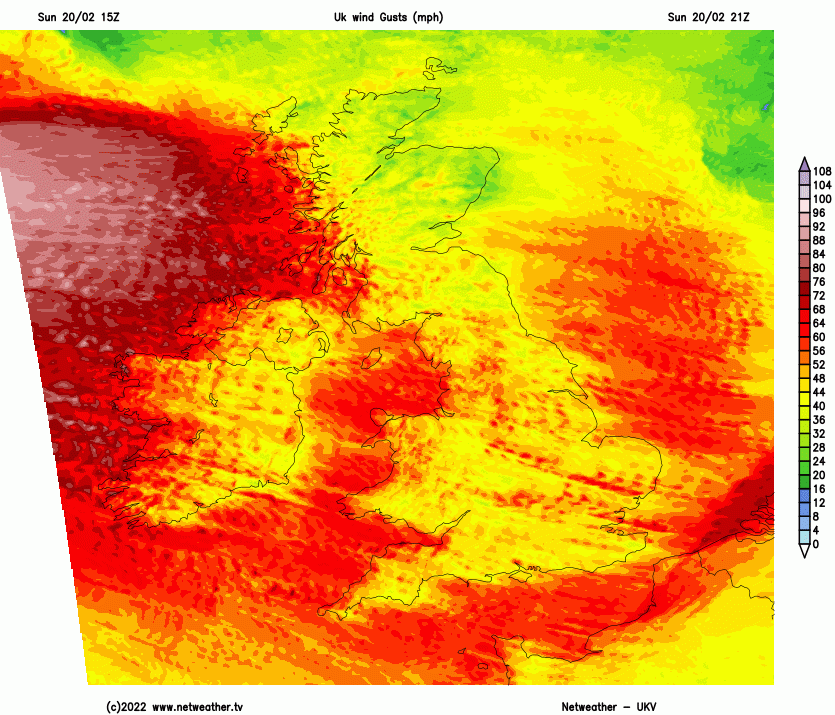
The seemingly endless windy weather has continued this weekend. In a week of 3 named storms (half term for some) it has been all go in the weather world. Dudley, Eunice and now Franklin. Northern Ireland has an Amber warning for Wind from the UK Met Office running from midnight until 7am on Monday morning with gusts of 60 to 80mph forecast.
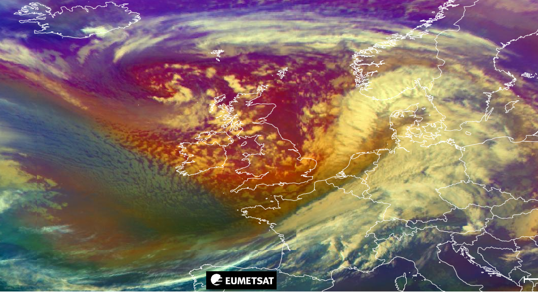
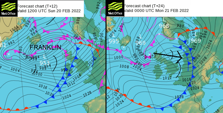
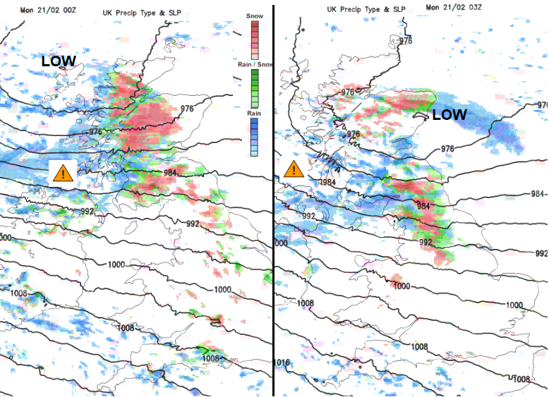
The low centre of Franklin has moved south of Iceland and will progress SE over Scotland during Sunday night but the cold front ahead of all this has brought some vicious weather across Britain on Sunday. The active cold front has marched south-eastwards with a band of torrential rain, sudden high gusts and even hints of tornadic activity in the line convection. There were reports from the Doncaster area of roof damage, lightning and roaring winds as the squall line moved through. Its arrival and progress through England has been quite an event on Sunday as people are still recovering from Storm Eunice. There are still thousands of homes without power.
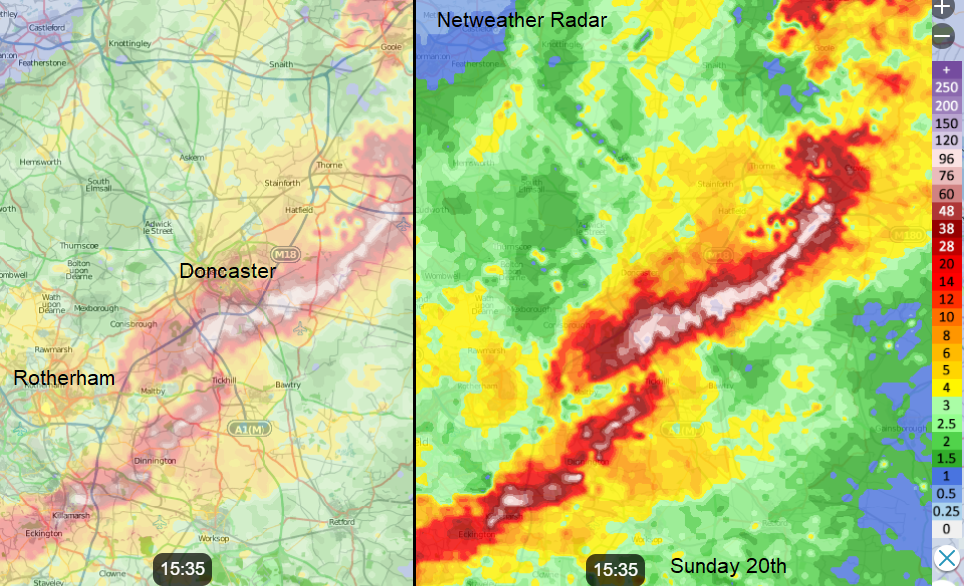
Bright echoes on the Netweather Radar showing torrential rain along squall line from cold front ahead of Storm Franklin
More widespread heavy rain on Sunday has led to flooding and evacuations with the highest river levels on record in places. Roads and bridges have been closed due to flooding in Yorkshire with two severe flood warnings for south Manchester. There is still rail disruption and Rotherham railway station had to be closed.
In Wales, there are also thousands still without power and concerns about flooding, especially around the Severn. Again, there has been a push from the strong winds along with heavy rainfall.
It is going to be wild into the early hours of Monday for Northern Ireland, particularly the coasts and also the Inner Hebrides and SW Scotland. Through the North Channel, for the Isle of Man and the Irish Sea across to Cumbria and Lancashire and Merseyside by dawn.
The Inshore waters forecast says “Most areas will have either gales or storm force winds” with the sea areas between Northern Ireland and SW Scotland & NW England mentioning Violent Storm (force) 11.
“A spell of very strong winds associated with Storm Franklin will bring disruption to parts of Northern Ireland early on Monday.
A swathe of very strong west to north-westerly winds will reach the north coast of Northern Ireland late on Sunday evening, quickly moving south into the early hours of Monday. Winds will ease steadily from the northwest during Monday morning. “Met Office Amber warning
Sunday evening
We already have fresh to strong westerly winds, with high river levels, standing water and a chill in the air. As the low centre moves towards western Scotland later this evening, any showers on the wind will become heavier with more sleet and snow. There will be heavy snow and blizzards for a time over the Highlands, Cairngorm and the Southern Uplands, reaching over the tops of Pennines during the night. Other northern hills will see sleet and snow in the showers tonight.
Monday morning
It will be very windy for Monday morning for Wales, England and Northern Ireland. Again, for western coasts and through the English Channel. This is covered by an ongoing wider yellow wind warning for the SW two-thirds of the UK, easing off by Monday lunchtime. It’s not quite the ferocious strength of Eunice from Friday but there has not been time to secure and repair after the last storm and so further damage and impacts are more likely. Rail companies are already issuing travel advice for Monday morning.
One of the differences with the warnings around Franklin is that this event is mainly overnight and at the weekend. Eunice was during the day on a Friday linked to school holidays. The UK warning system is impact based, not just linked to numeric levels.
One low centre will have already moved over Denmark and southern Sweden to the Baltic Sea with strong winds and wintry weather. The small low centre from Scotland will push down the North Sea towards northwest Germany and the Netherlands with wind warnings out there too.
Don’t put your recycling out early and be prepared for possible delays on Monday morning. Further discussion and chat on the community forum Storm Franklin