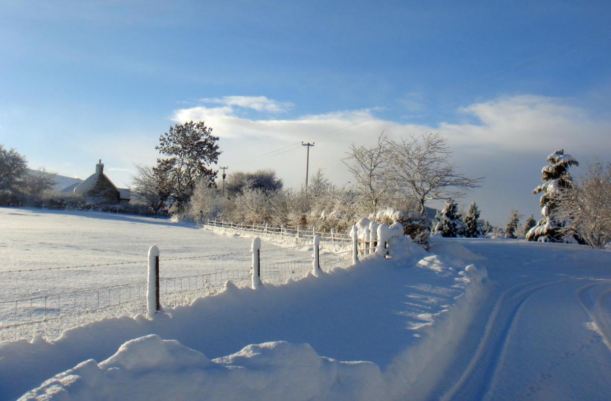
An easterly flow will bring snow and much colder air with frost and ice into next week. Scotland is already being warned of wider blizzards and disruption by Friday but snow showers will spread.
The weekend forecast already has severe weather warnings for heavy snow and blizzards for Scotland with a bitter wind chill and an easterly flow off the North Sea. That cold easterly wind and the snow showers will spread to more Britain next week with widespread frost and ice, but is this a 'Beast from the East'?
Not all easterly winds and snowfall equal a Beast, whatever some sources may shriek, year on year. The last one was recent, at the end of February into March 2018 and that one was an extreme weather event.
‘Beast from the East’ is an unofficial informal term for a snow-making setup of deep bitter cold and significant snow reaching the UK on a long-lived easterly flow. It sends Coldies and snow lovers into a delighted frenzy but also, unfortunately, the Tabloids and other media sources for months. And so the warning messages, from forecasters who care, have been diluted by nonsense. When preparations would be useful but not to alarm people.
A series of events up high in the atmosphere have been taking place over recent weeks, including SSW Sudden Stratospheric Warming and the reversal of the Polar jet which happen from time to time but now there are strong signs from the various models that an easterly flow at the surface will set in for next week and bring snow to more of the UK from the North Sea. Scotland is already under Amber warnings for real winter.
“Snow is expected to become more widespread, persistent and heavy, and will settle at increasingly low levels. Drifting snow, temporary blizzard conditions, and ice forming on exposed power lines and phone masts.” MO
There have been wobbles in the various models, they don’t all agree all of the time, which lowers the confidence of the forecast and keeps everyone on tenterhooks. NE Scotland looks set for the worst of the snowy weather, eastern Britain a share of it but further south a lingering surface low keeps upsetting the wider story.
Rather than having to label it just yet, take this as a heads up for a spell of much colder weather and possibly proper snowfall. Eastern Britain will be more in the firing line for the snow but with the deep cold, any frontal systems that do nip in from the SW could bring snow to other areas. And with brisk easterly winds the snow showers will manage to work their way right inland.
This stepping towards (but not fully into) Beast from the East territory but there is still something of an uncertain balance going on. The further northeast you are, the forecast stays very cold, snowy and easterly. Further south, it’s wobbly. Certainly not the longevity and depth of the 2018 event.
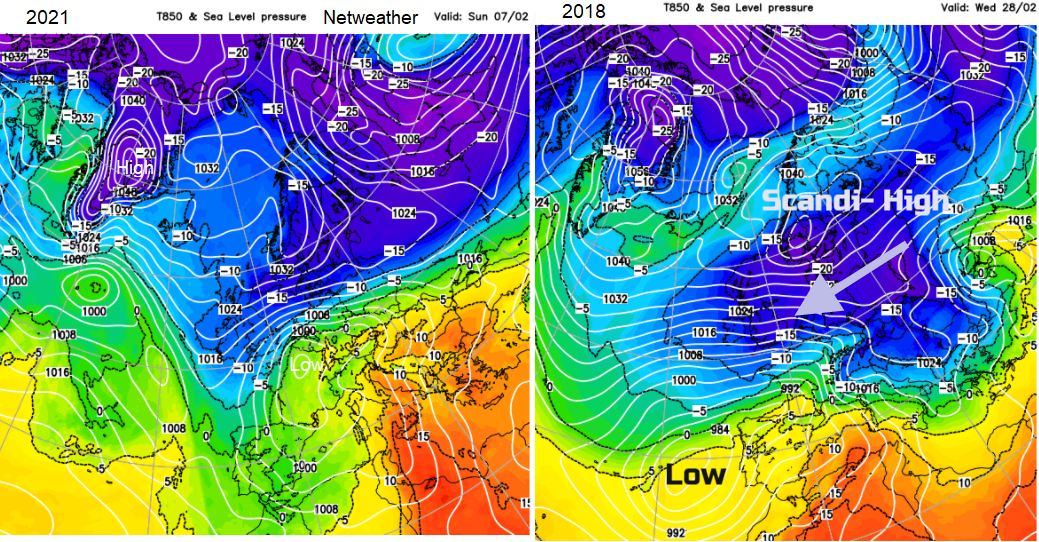
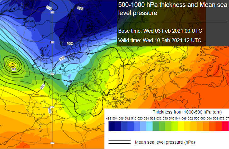
Things that add up to a proper Beast from the East: Cold air higher up in the atmosphere: below -10C for the 850hPa temperatures linking back to even colder air way over northern mainland Europe/Russia. Under 514dam on the 500-1000hPa thickness charts, maybe lower. Some longevity to the event, not an overnight blast. This needs to be steady and continued, anchored by the Scandi High with surface temperatures over the UK falling in the continued onslaught of cold air. And snow, what’s the point of this without deep snow. It is a snowmaking process, that much colder air over the relatively warmer North Sea driving the convection, with a feed of snow showers, troughs and streamers setting in which pile snow along certain lines set up by the orography of Britain.
Meanwhile, it’s a time to sort what we can with our homes, heating and outside taps, just in case. Most people aren’t travelling as much so it shouldn’t be like the snow in 2018 when people were trapped overnight in the Central Belt down through the A1 and lorries in Kent. However, the vaccination rollout continues and delay or disruption to that is unwanted. Health board advice in wintry weather “Avoid exposing yourself to cold or icy outdoor conditions if you are at a higher risk of cold-related illness or falls.” Winter cold is a major contributor to excess winter deaths (months Dec-March).
For people whose body, respiratory system or heart just manages or whose medication allows them to function at a certain level but not much beyond, severe cold is physically dangerous and there is enough going on at the minute health-wise anyway. For those just needing to get outside once a day for their own wellbeing, a longer spell of bitter cold, ice and snow might be viewed with dread. Parents needing to release children outdoors or facing February half term coming up, any snow might be a welcome blessing in the entertainment stakes.
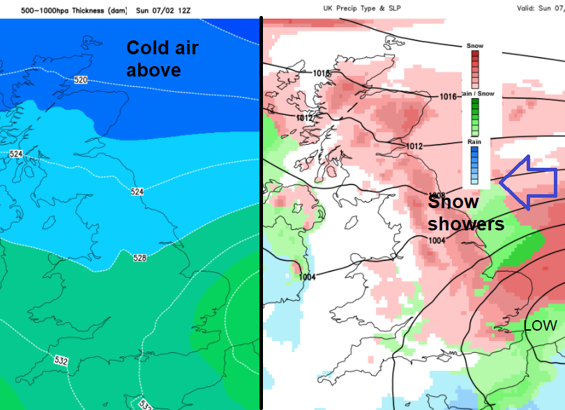
Currently the Amber warnings for snow cover Friday and Saturday for areas of Scotland north of the Central Belt with a wider snow warning from Thursday through until Sunday over more of Scotland. A snow and Ice warning runs from Saturday through into the start of next week for NE and eastern England but extending into the Midlands, this is as the easterly flow takes hold and the risk of snow showers increases. Looking at the model output it doesn’t have the resolution to show showers at that range so we get these larger areas of pink for snow risk, not that everyone in eastern Britain will see deep snow. NE Scotland remains the focus for now for the worst conditions and the coldest air. SE Britain keeps uncertainty due to how this weeks’ lingering low pressure finally clears away. Until it does the proper cold easterly can’t move in, that is causing great frustration.
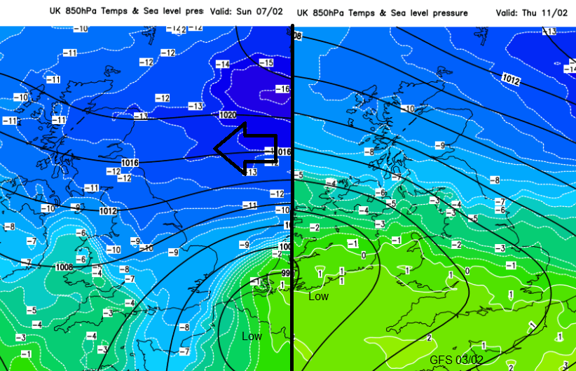
Next week as the easterly flow takes hold well, north of The Wash, more snow showers head in. A low centre on the ECM model adds uncertainty for SE Britain and later more uncertainty about a large low pressure out in the Atlantic which the GFS brings in by Thursday next week and that could introduce frontal rain and snow from a different direction. That would interrupt the whole solid easterly flow setup, although Scotland looks to stay on the colder side of everything even into mid February. .