The weather models have been exhibiting a great deal of uncertainty with regards to guidance on what the weather will do past as soon 5-6 days ahead. There has been a lot of speculation over very cold easterly or northeasterly winds developing later next week. The American GFS model has been fairly bullish with this idea for a number of days, with most of its four daily runs carrying along with it, though with varying degrees of depth of cold and longevity of cold. Similarly the Canadian GEM model, which probably spotted first the potential for cold easterly winds to develop later in the week, has been bullish. However, the European ECMWF model, has on the whole been uninterested over the last few days, but now appears to be edging towards developing a cold easterly flow next weekend.
The uncertainty past day 5 seems to revolve around whether low pressure close to the west of Ireland for much of the week sinks south later in the week. If the low sinks south, it would allow an easterly flow to develop. Or, as ECWMF had indicated until the last few runs, the low stays put – with no easterly.
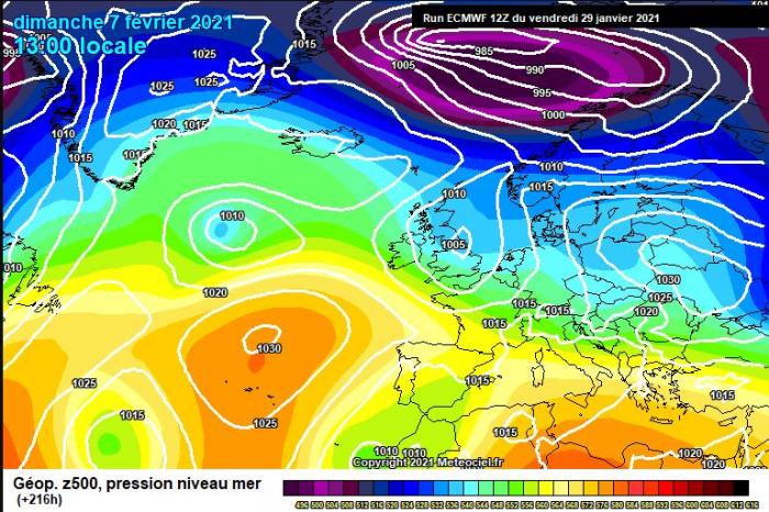
On Friday, the 12z ECMWF run was showing no easterly for this coming Sunday:
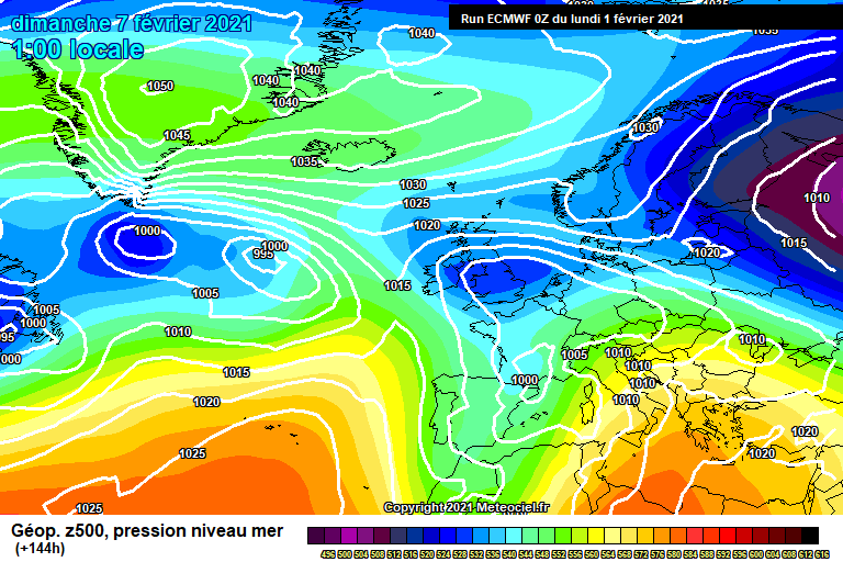
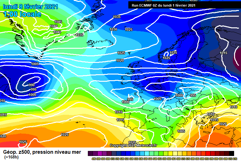
However, this morning's 00z run of ECWMF indicates an easterly developing between 00z Sunday and 00z Monday, inline with what other models have been showing since before Friday:
The amount of uncertainty at such close range is possibly related to how the models are dealing with uncertainties with the upper flow over the Atlantic and further north over the arctic. This uncertainty may be caused by the less than usual interactions coming together of a strengthening MJO moving across the western Pacific, a weak stratospheric vortex and a winter storm over NE USA strengthening the jet stream.
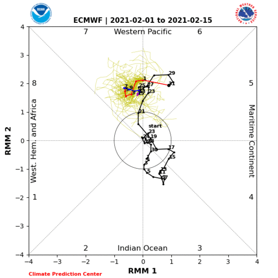
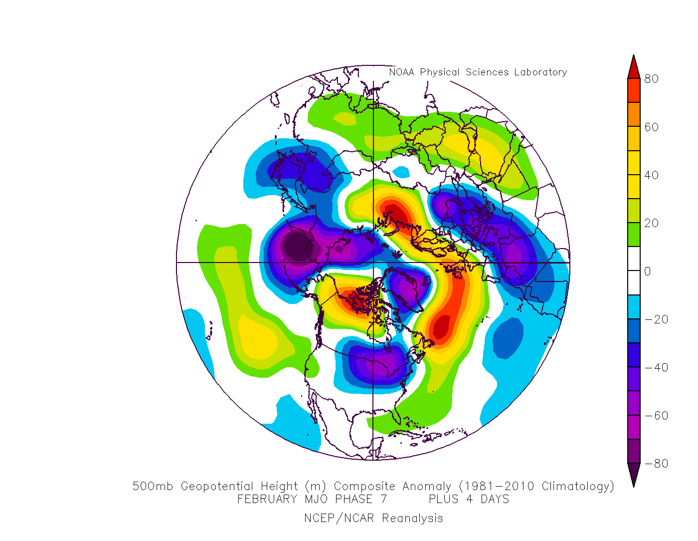
The MJO (Madden Julian Oscillation), which is wave of tropical convection that circumnavigates the globe, is forecast to pass over the western Pacific. However, the position or phase over the western Pacific and its strength has varied between models and the daily runs of each model over recent days. The models have been swaying between phase 6 and 7, phase 7 is more correlated to amplification of the upper flow over the Atlantic with blocking regimes developing from the Atlantic NE towards Svalbard and a southerly tracking jet stream – which can lead to cold outbreaks over northern Europe.
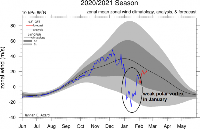
Meanwhile, the weak and displaced stratospheric vortex, following the sudden stratospheric warming early in January, is allowing high pressure to build over arctic regions – where the polar vortex resides. The uncertain movements of the weakened polar vortex and the arctic high appears to be causing some issues with modelling high latitudes. Add into the mix, a sharp thermal boundary causing a slow-moving winter storm over NE USA, which is causing the jet stream to strengthen. This combination perhaps leading to greater uncertainty at short time leads.
When there is such great uncertainty between the higher resolution operational runs of models or between the operational runs of one model, weather forecasters often turn to weather model ensembles. This is where instead of running just a single forecast, the weather model is run a number of times, each with a slight variation of its initial conditions and with slightly perturbed runs they produce a range of possible weather conditions. If there is a larger grouping or clustering around one scenario – then there is increased confidence in this scenario coming off.
With regards to the ensembles, the mean of the ensembles spread of both GFS and ECMWF runs over the weekend and this morning have pointed to a cold easterly developing this weekend. However, the operational / high resolution runs, despite now finally agreeing on easterly developing at the weekend, still differ with when the easterly starts and the depth of cold across different parts of the UK.
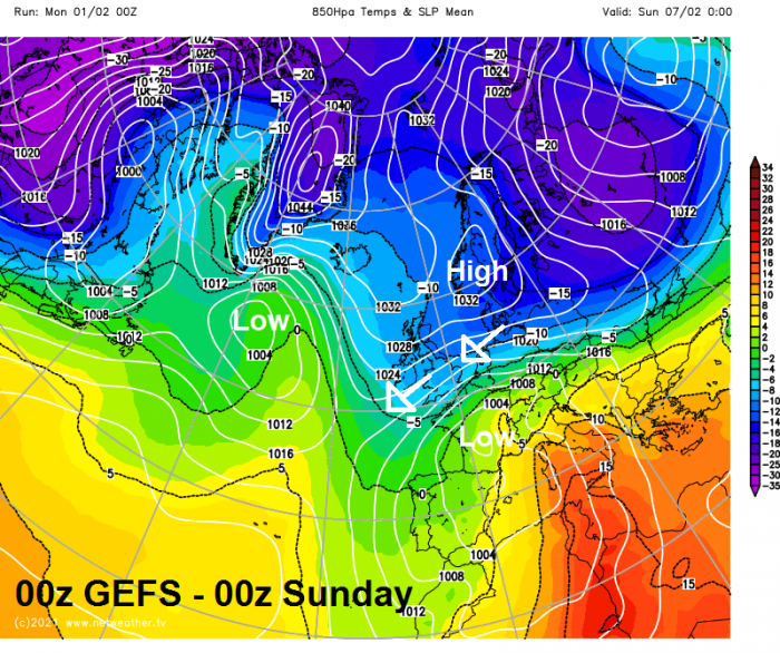
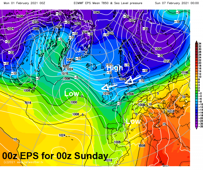
00z GEFS and EPS mean mslp shows high pressure to the north, low pressure to the south and southwest.
For the rest of this week, it will be snowy across northern England for a time on Tuesday morning as Atlantic frontal system moivng up from the southwest bumps into cold air across the north. Greatest accumulations over hills with 5-10cm in places, but some accumulations to lower levels too up to 1-3cm, before milder air wins out from the southwest. However, as the frontal boundary bringing snow on its northern edge reaches Scotland, it looks to stall for a few days, bringing a snowy week to central and northern parts, before the bondary sinks back south.
The cold easterly flow Scotland then looks to sink south later in the week and into the weekend, as the frontal bondary sinks south in conjnction with low pressure eventually sinking south. The easterly flow developing further south likely to bring in increasingly deep cold, perhaps 850 hPa (circa 1500m above) temperatures falling to -10C and below which correlates to temperatures near the surface dropping closer to freezing, then there will be an increasing risk of snow showers developing over the North Sea and affecting eastern areas, as the sharp contrast between deep cold air above relatively warm sea temperatures creates convection. Also, with low pressure close to the south – associated fronts may bring more prolonged snow across the south – if it’s a frontal boundary separating milder air to the south – then snow on the northern side and rain on the southern side of the boundary. However, the details of when, where and how much it will snow later in the week and over the weekend are too uncertain this far off. But the potential is increasing as it turns colder from the east over the weekend. It will be clearer later in the week where and when the coldest air will arrive and with it the potential for snow. Northern areas look to be first, then perhaps southern areas later in the weekend.
Loading recent activity...