


Latest synoptic outlook - focusing on risk of snow this evening, overnight and Wednesday morning. Then a rapidly deepening low, storm Rachel, bringing severe gales and heavy rain across the UK Wednesday night and Thursday morning.
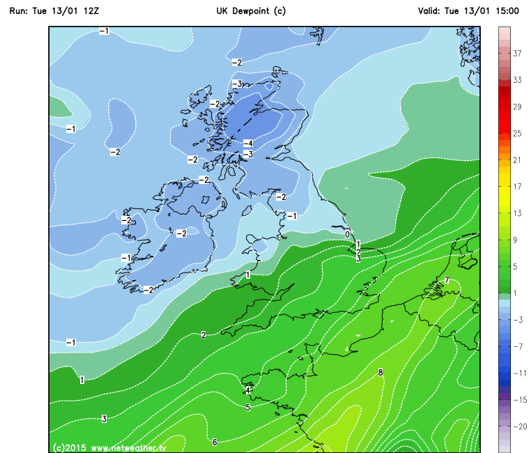
The cold front which brought heavy overnight rain across southern England and south Wales cleared away into the near continent this morning and we are now seeing progressively colder air flood southeast across much of the UK this afternoon on the westerly flow. The cold polar maritime airmass, is originally frigidly cold polar continental air coming out of NE Canada, but has modified whilst crossing the warmer Atlantic waters. Still, this airmass has been cold enough today across Scotland, EIRE, Northern Ireland and northern England for snow to fall to lower levels. Generally, the dew point of the surface air needs to be 0C or below for snow to fall to surface, and as you can see on the dew point chart below, much of the areas I've just mention are seeing this, even though the air temperatures are 1-3C above freezing. Further south, the temperatures and, critically, the dew points have still yet to fall away sufficiently for snow to fall to lower levels, though we are now seeing snow fall from showers over the Welsh hills, SW Moors, tops of the Mendips and Cotswolds with the air colder with a bit of altitude.
This evening and overnight, frequent snow showers will continue to pile up the accumulations across Scotland, EIRE, Northern Ireland and NW England. We currently have a trough arriving across N. Ireland and Scotland, which looks to bring outbreaks of more persistent snow in time for the evening rush hour, which will bring 3-5cm in a short space of time, perhaps locally 5-10cm over 100m, and more above 250m on slopes exposed to the westerly wind. Frequent snow showers or more persistent spells continuing into the night across EIRE, N Ireland and Scotland and also spreading in across Cumbria and the north Pennines, bringing an increasing risk of travel disruption in these areas, particularly for the higher routes.
Further south, the air will get progressively colder across southern areas from the west this evening and overnight. A shortwave trough is indicated to run east across south Wales. south Midlands and southern England tonight, enhancing shower activity, before clearing SE England and East Anglia by dawn. These showers are likely to be heavy and falling as hail, sleet and snow and also with the odd rumble of thunder. Snow looks possible even to lower levels inland in these areas, perhaps giving temporary slushy accumulations, higher ground above 100m may see 3-5cm locally - particularly Welsh hills, English Borders, SW Moors, Mendips, Cotswolds, Salisbury Plain and the Chilterns.
Another trough is indicated to move east across Scotland Wednesday morning, bringing another spell of more persistent snow, which may coincide with the morning rush across the central belt, bringing the risk of travel disruption.
Image courtesy of the Met Office (t+24 fax for 06z Weds)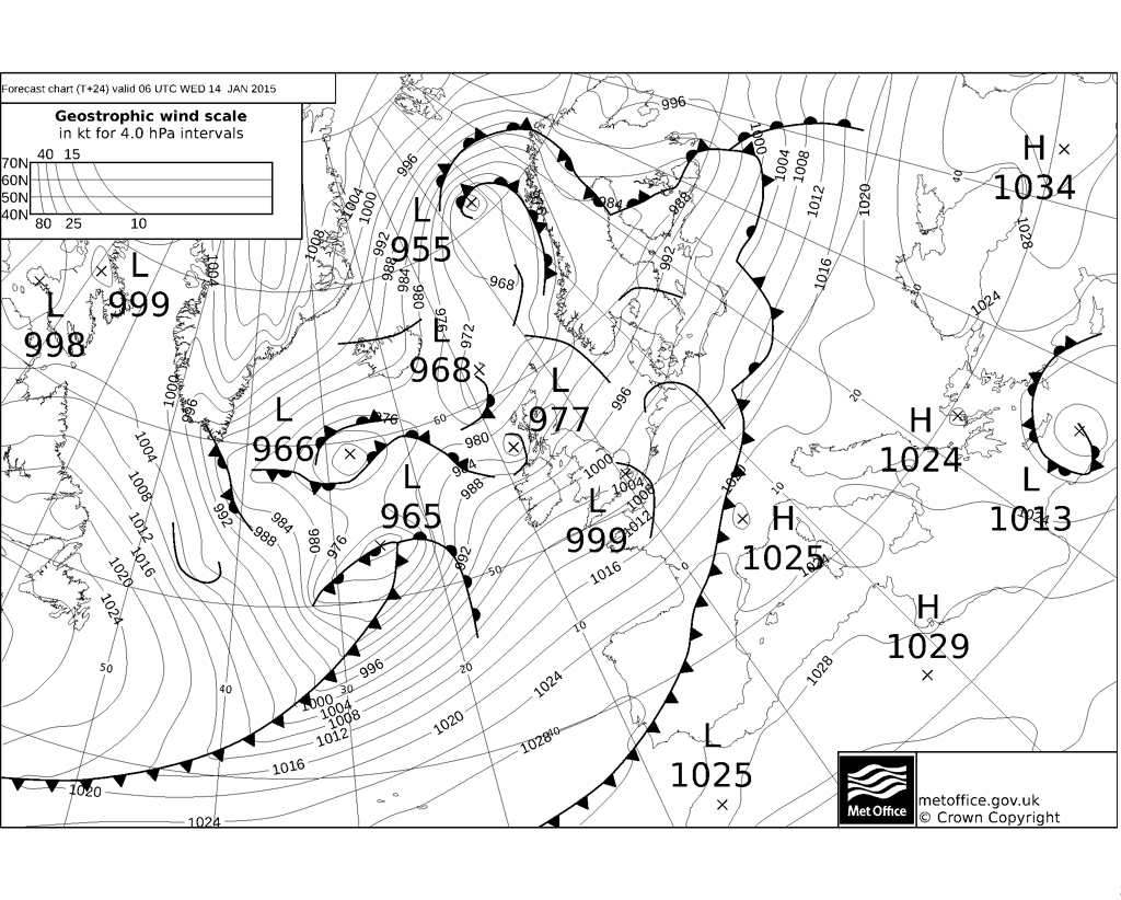
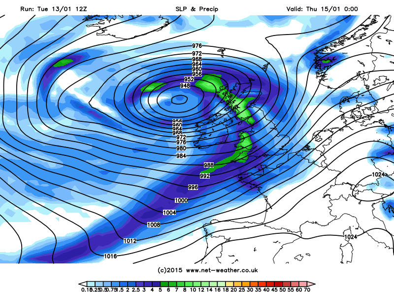
The rain, sleet and snow showers then ease away from most areas by late morning or early afternoon on Wednesday, though perhaps a few still continuing across central and northern Scotland into the afternoon. Then all eyes on a deepening storm 'Rachel' that looks head over the Atlantic towards NW Scotland early Thursday. The culprit depression left New Foundland this earlier this morning as a fairly innocuous looking shallow area of low pressure, but it is forecast to rapidly deepen over the Atlantic during the next 24 hrs, as it moves under the developmental left exit of strong jet stream and engages with a sharpening shortwave upper trough leaving NE Canada. This intense depression will then swing northeast towards NW Scotland Wednesday night. Ahead of this approaching storm, southwesterly winds will pick up and strengthen to gale or severe gale force in the west later in the day, bringing milder air and also outbreaks of rain by early evening. The rain will initially turn to snow over Scotland, Northern Ireland, NW England and Wales as it spreads east through the evening, bringing further wet snow to lower levels and several cms over higher ground before a thaw sets in as milder air pushes in with 'warm' sector. However, the winds will be the main issue Wednesday night and through Thursday. A spell of heavy rain along a cold front, accompanied by gales or severe gales, will sweep east across all areas Wednesday night. ahead of the low pressure system. Winds just ahead of the squally cold front are likely to gust to 50-60mph quite widely inland early Thursday morning, 60-70mph along southern and western coasts and hills and to the east of high ground, perhaps 70-80mph over exposed coasts and headlands through the Irish Sea, English Channel and Atlantic coasts of western Britain. Rain will clear the southeast of England Thursday morning, to join other areas to brighter and increasingly colder conditions with wintry showers. Still very windy in the north though, as a very deep low (dropping to 944mb as per 12z GFS) brings severe gales or storm force winds on its southern flank in the far northwest, we could see wind gusts of 80-90mph or even higher across NW EIRE, north coast of N. Ireland Thursday morning and also west coast of Scotland. Winds easing elsewhere, but still a windy day.
Then staying on the cold side on Friday mostly bright or sunny but also wintry showers - especially across the north and west, with further snow for Scotland, Northern and Northern Ireland, models indicate a trough moving SE across northern Britain in the strong northwesterly flow - which could bring a spell of more persistent snow. More on this later in the week.


