As the Christmas getaway starts to shift into motion, there have been press releases from motoring organisations highlighting the most likely traffic delay times and spots. Sections of the M1, M5, M6 and M25 are expected to see the worst delays. Millions of people will be travelling in the run-up to Christmas with the roads being exceptionally busy along with train journeys. Adding severe weather to all that would be a nightmare, always a risk at this time of year.
The Highways Agency is aiming to have completed or cleared most roadworks across England by early Friday 20th and car users are reminded to do a few checks before heading off, to do their bit. Checking tyre tread and pressure, oil and coolant levels, filling your screen wash and taking a de-icer.
The roads will be especially busy this week as usual commuters and school traffic are joined by Christmas travellers and shoppers. The weather isn’t looking too bad, no dangerous storms or severe winter weather over the next few days but there will be more rain. With the recent months of wet weather, the ground and rivers are sensitive to any more water and so the risk of flooding resumes.
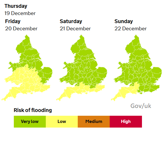
This risk is mainly for southern England. Rain warnings mid-week cover more of central England and Wales and there is another Rain warning for central-eastern Scotland on Thursday but it is southern counties of England which are most at risk as pulses and bands of heavy rain continue to arrive and the conditions on the ground can’t cope.
Local flooding is possible from surface water and rivers across parts of the south-west of England and the south of Wales, from later today (Wednesday) through until Friday and is possible but not expected for the south-west of England only on Saturday and Sunday. Local flooding is also probable from surface water and rivers across central parts of England from later Wednesday until Friday and for the south and south-east of England from later Wednesday through until Saturday. Land, roads and some properties may flood and there may be travel disruption. Env Agency
With more of a breeze and milder air from the south, there shouldn’t be any more fog problems which is good news for airports and people getting away.
Also, no frost or ice warnings, good news for early morning rail travel. Rail passengers have been advised to plan ahead due to engineering works and strikes but there aren’t any more frost warnings this week.

The wind warning runs from Wednesday until the early hours of Thursday for western Britain and Northern Ireland. The strong winds and heavy rain midweek are linked to a weather system that was named by the Portuguese Met Service IPMA, Storm Elsa. This is bringing wet and windy weather to NW Iberia but also affecting our UK weather, and an Orange wind warning for Cork has been issued by Met Eireann. Usually enough to prompt a named storm here, but no #StormBrendan, as another part of Europe named first.
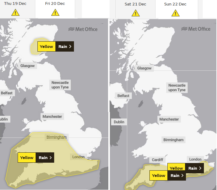
Rain warnings cover SW England and then southern England through until Sunday but much of the rest of the UK should have fair December weather. Disruption from flooding remains a concern and in heavier rainfall, there will be surface water, spray and poor visibility on the roads, especially for SE England on Friday evening as some people finish up for the holidays.
Storm Elsa - Netweather community forum discussion
Loading recent activity...